St. Louis
St. Louis is an independent city and major American port in eastern Missouri. Standing on the Mississippi River, it is the largest city in the state and was founded as a fur-trading post by the French in 1764. It was held by Spain from 1770 to 1800 and then returned briefly to France (1800), before being ceded to the USA in the Louisiana Purchase of 1803. St. Louis was the capital of the Territory of Missouri from 1812 to 1821. During the American Civil War, the city was a supply base and medical centre. Today, it is the seat of three universities, a financial centre and a market for grain and livestock. Industries, past and present include motor vehicles (which has seen a state of decline in more recent times), brewing, chemicals, aircraft and food processing. At the time of writing, St. Louis has a population of a little over 300 million. This webpage features some of the areas in and around the city visited during a trip here in 2017.
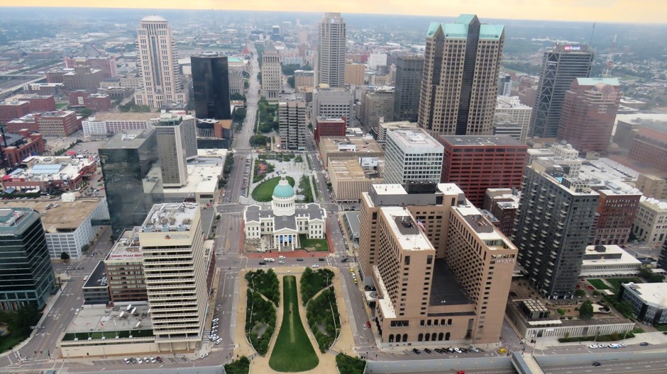
Above: Modern Downtown St. Louis, as viewed from the Gateway Arch
The city has much to offer the visitor. Probably the most famous landmark is the 630 foot tall Gateway Arch, built in the 1960’s to honour the early 19th century explorations of Lewis and Clark, amongst others, and the nation’s westward expansion in general. Replica ‘paddlewheelers’ can be taken on the river, offering views of the arch and the downtown area. The city’s Soulard district is known for its barbeque restaurants and clubs playing blues music. Other attractions include the City Museum, Forest Park, Missouri Botanical Garden, Saint Louis Zoo, the Busch Stadium (home of baseball team the St. Louis Cardinals), the Saint Louis Art Museum, and across the river in Illinois, the Cahokia Mounds (dealt with on a separate webpage on this site Here). The photographs on this webpage were taken in August 2017 and accompanying them below is some descriptive text about the sites visited.
The Gateway Arch National Park, formerly known as the Jefferson National Expansion Memorial, is the site of a world-renowned masterpiece of modern architecture for which it is named after, constructed on the banks of the majestic Mississippi river, right in the heart of downtown St. Louis. It was somewhat fortuitous on arrival at the base of the arch, which rises skyward from a forested park and this national historic site that there were no long queues and it was possible to simply buy a ticket and after a brief security check, ascend one of the nation’s must-see iconic structures to gain views over not only one of the most famous rivers in the world, but the cityscape and beyond in a westerly direction, to marvel at the distant landscape which the early pioneers of a country in an embryonic state would have headed for, without knowledge of what may lie beyond with only eyesight from ground level. The national historic site here was created in 1935 to memorise the city’s role in westward expansion of the USA.
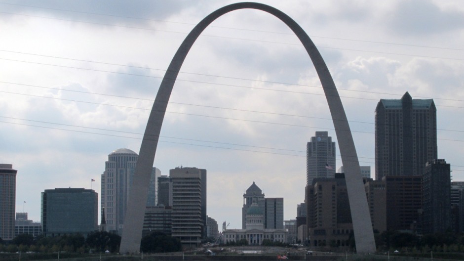
Above: The Gateway Arch, as viewed from the Malcolm W. Martin Memorial Park on the opposite bank of the Mississippi River in East St. Louis
Over 200 years ago, the land west of St. Louis was unchartered territory and all a bit of a mystery for most citizens of the fledgling United States. However, by the 1890’s, most of this land had been explored and settled within just three generations of Americans (Thomas Jefferson thought it would take one thousand generations for Americans to fully extend across the vast continent, but this happened in fewer than 90 years). The westward pioneers largely displaced the original inhabitants, bringing their own customs and cultures to the continent, west of the Mississippi. St. Louis played a central role in this expansion of Americans and became a centre of commerce with large volumes of trade via both the Mississippi and Missouri rivers. The city became a bustling and multicultural metropolis and formed a base for explorers (most notably Meriwether Lewis and William Clark, Zebulon Pike and Stephen Long), trappers and mountain men whom set up systems of trade with the native Indians. Before the completion of the transcontinental railroad in 1869, St. Louis formed an essential supply base for thousands of wagon trains heading west. Over 300,000 settlers headed westwards with promises such as free land, religious freedom and seeking a fortune from gold. Throughout the 1800’s, St. Louis was a major military depot providing support to the army whom displaced Indian tribal groups. It formed a key role in westward expansion and one of not only historical triumphs, but one of defeats, destruction of cultures and the events of the era are commemorated here. Some photographs taken from the Gateway Arch National Park area and adjacent Downtown areas may be seen in the thumbnail gallery below (click on an image to enlarge):
In brief, the Gateway Arch is a big one. It was built between 1963 and 1965 and is a stainless steel clad, carbon steel and concrete structure rising some 630 feet (190m) in height, making it some 75 feet taller than the Washington Monument and over twice as tall as the Statue of Liberty. In 1947, a competition was held to design a memorial here on the former site of a French fur trading post which dated back to 1764. The competition sought to find an architectural design which would symbolise the dramatic story of westward expansion. From 172 entries, judges chose a design by Eero Saarinen which would be to build the Gateway Arch. In his words, “Neither an obelisk nor a rectangular box nor a dome seemed right on this site or for this purpose. But here, at the edge of the Mississippi River, a great arch did seem right”. Saarinen’s other works include the TWA terminal at JFK airport in New York City and Dulles airport outside Washington D.C. - both other daring designs pushing engineering, materials and technology to new expressions of artistic creativity. Both Saarinen and long-time collaborator Dan Kiley, a master of modern landscape architecture, designed the landscape surrounding the Gateway Arch. On a site where 40 blocks of old buildings were levelled in the core of the downtown area, tree-lined walks, rolling hills, reflecting ponds and a grand staircase descending into the Mississippi River were laid out, mirroring the shape of the Arch. Some photographs taken from atop the Gateway Arch may be seen in the thumbnail gallery below (click on an image to enlarge):
Standing for the many cultures that made the American West what it is today, the Gateway Arch had to be carefully planned as nothing like this, in terms of a feat of engineering, had ever been built or attempted before. Precise measurements ensured that two freestanding legs were formed with tensioning rods to ensure each side was kept from tipping over, until the final keystone piece could be put in place, fitting exactly at the top of the 630 foot tall structure providing eventual stability. The project took place with considerations given to factors, such as high winds, large variations in air temperature, dizzying heights for the workers and uneven surfaces. On the final day of construction, an audience watched with great anticipation as a crane settled the keystone into place. An internal tram system was put in place in just two weeks by elevator designer Dick Bowser and still serves to this day, taking some one million people annually to the viewing area at the top, where small downward tilting windows offer an opportunity to take in panoramic views eastwards down to and beyond the eastern side of the river and in a westerly direction over the city of St. Louis and as far as is visible on any given visit.
World Chess Hall of Fame
Changing the subject on this visit to “The Lou”, St. Louis has also been dubbed America’s chess capital (as well as “Chess Capitol of the World”). This status started to develop from 2008, when Rex Sinquefield decided to promote the game of chess in his hometown as a retirement project after making his fortune pioneering stockmarket index funds. As well as being actively involved in politics, he founded the Chess Club of St. Louis, which ultimately became the headquarters of American chess.
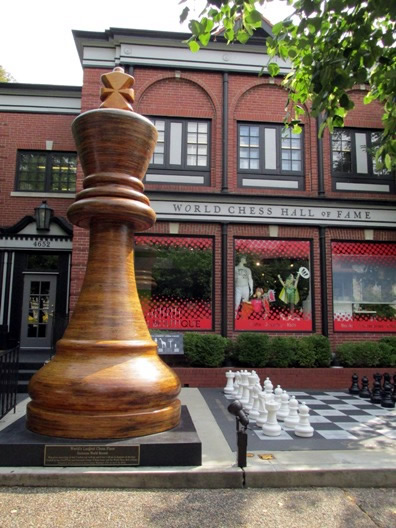
Shown here are photographs taken from a visit to the “World Chess Hall of Fame”, a non-profit, collecting institution situated in the Central West End neighbourhood of St. Louis. Rex Sinquefield helped with bringing this Mecca for chess fans to the city in 2011. It is the only institution of its kind anywhereand inside the 6,000 square foot centre can be found a museum, a hall for tournaments, classrooms, a library, a shop and an area where live chess tournaments can be followed. Exhibits on multiple levels include artworks, actual boards and pieces used in world chess championship tournaments (think Boris Spassky and Bobby Fischer)and the Hall of Fame which in the chess world is akin to stars on the Hollywood Walk of Fame in the world of acting. Some 1,000 members of varying skill levels attend classes here on this dedicated site which serves to present “World-class exhibitions that explore the connection of chess to art, culture, and history”. It was on a personal note that the author of this webpage saw recorded in the Hall of Fame a dedication to the Soviet and Russian chess grandmaster Vasily Smyslov (1921-2010). The author’s father won a game against him in London, during a simultaneous exhibitionyears gone by, and as a passionate player went to Russia in the 1960’s to play for Cambridge University. As far as the author is concerned here, due to lack of intelligence and wasting my time growing up playing computer games in the 1980’s, I know I have reached the age whereby Icould never be capable of reaching such levels of competence in this number one game of all games; my personal motivation to play chess was diminished at an early age, but admire those whom play with passion. For more information on the World Chess Hall of Fame, a link to the website may be found Here. More photos of the visit can be seen in the thumbnail gallery below (click on an image to enlarge):
East St. Louis (Illinois)
Directly across the Mississippi River from St. Louis is the Southern Illinois city of East St. Louis (ESL). The city is not exactly on the tourist trail, although the interest of the author of this webpage for coming here was twofold - firstly to look at the city’s abandoned buildings and secondly to look at some views of downtown St. Louis itself as seen from the opposite bank of the river atop a viewing platform in the Malcolm W. Martin Memorial Park (see lower down the page).
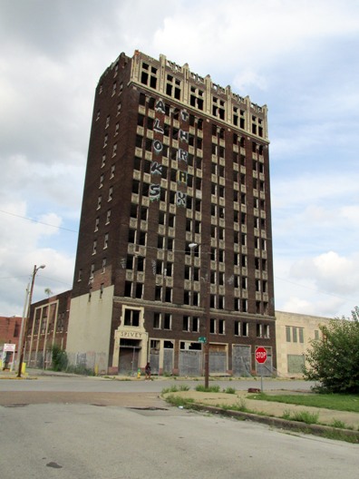
Above: The Spivey Building in downtown East St. Louis has stood abandoned for decades, and is the tallest building in the city.
Many other people come here for gambling. In 2013, East St. Louis was considered to be the most dangerous city in the contiguous United States, based on violent crime statistics. A visit here gives a glimpse of the sort of issues that poverty-stricken U.S. urban areas have faced in recent times. Some photographs taken of East St. Louis may be seen in the thumbnail gallery below. They were mainly taken from a car as for reasons of not only practicality, but safety, it was decided not to take public transportation or explore on foot.
Some more photographs of buildings in East St. Louis can be seen in the thumbnail gallery further up the page which shows photographs taken from atop the Gateway Arch (e.g. photos 44-48). Points of interest in East St. Louis also include the Katherine Dunham Museum, dedicated to the life of a famous dancer, and the Jackie Joyner-Kersee Center (after the American retired track and field athlete), which opened in 2000 to help her hometown and encourage participation in sports. As mentioned above, East St. Louis is considered a dangerous city and is noted for high crime and drug rates. Visitors should avoid walking the streets at night.

The photograph above shows the Malcolm W. Martin Memorial Park. Its main feature is the Gateway Geyser, a fountain that lifts water up to 630 feet (192m). The fountain serves as a counterpart to the equally tall Gateway Arch on the other side of the river. Around the fountain are four smaller “geysers”, which each represent the four rivers which converge near the two cities, namely the Mississippi, Missouri, Illinois, and Meramec. A 40 foot (12m) Mississippi River overlook platform here provides excellent “postcard” views of St. Louis and the river and stands adjacent to a small parking lot. Free to access, there is also a webcam on top and if the visitor notes the time, for a period after visiting, it is possible to go online to see a recording from the original live web broadcasting. Also here of note is the Malcolm W. Martin Statue. The park and statue honours Malcolm W. Martin who was a St. Louis attorney whom supported an original concept of the National Expansion Memorial to touch both sides of the river. This never came about due to lack of funding and in subsequent years, he founded the Gateway Center of Metropolitan St. Louis to fund land acquisition for a park here on the Illinois side of the river. Also in the park may be seen a 100-foot (30m) flagpole. The geyser is not in action in the photographs on this webpage; it has just one 10 minute-long scheduled eruption each day from May 1 to September 30 which is also dependent on weather conditions and periods of maintenance. Some more photographs from the visit to the Malcolm W. Martin Memorial Park may be seen in the thumbnail gallery below (click on an image to enlarge):
Other Areas Visited Nearby
Located to the north of present-day East St. Louis is the previously mentioned Cahokia Mounds State Historic Site (in Collinsville, Illinois). This is the site of a pre-Columbian Native American city (circa 1050–1350AD) and is dealt with on a separate page on this website Here. Also, further north, a visit was made to the city of Alton, Illinois, home of the tallest man ever to live on earth, Robert Pershing Wadlow and a page on this website about the visit and his life may be found Here.
Of course, there are many other sides to St. Louis and the surrounding areas not featured on this webpage, but the aim here has been to simply describe those places seen on this particular visit.
Back to Top