The Cahokia Mounds are an archaeological site located in southwestern Illinois, USA, on the Mississippi River floodplain, near Cahokia and Collinsville, just opposite the city of St. Louis, Missouri. The site, which included at least 120 mounds, over an area of approximately 4000 acres, is the largest prehistoric Indian site north of Mexico. Today, some 70 of the remaining 80 mounds over an area of 2200 acres are protected as a State Historic Site by the State of Illinois,. It was named a US National Historic Landmark in 1965 and in 1982, Cahokia Mounds was listed as a UNESCO World Heritage Site for its significance in the prehistory of North America. The photos on this web page were taken from a visit in 2017, where some time was spent exploring the very informative visitors centre and walking up to the top of the tallest mound seen today, Monks Mound.
Although the site was named after the Cahokia tribe of the Illiniwek (Illinois) confederacy, these people arrived in the area in the 1600’s and the mounds were built much earlier. Around 700 AD, the first people, Late Woodland Indians, came to settle here. They lived in villages around Cahokia Creek, hunting, fishing and growing crops. From around 1000 AD, the Mississippian culture started to develop into structures social communities with socially ranked and organised political systems. The community was supported by excellent resources, growing crops such as corn and squash and alongside the hunting, fishing and gathering, was able to support a growing population in a more permanent settlement. After 1050 AD, Cahokia became a regional centre, supporting surrounding farmsteads, villages, and satellite towns (with several mounds).
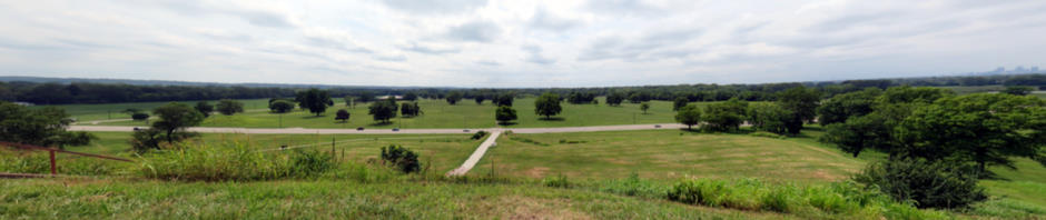
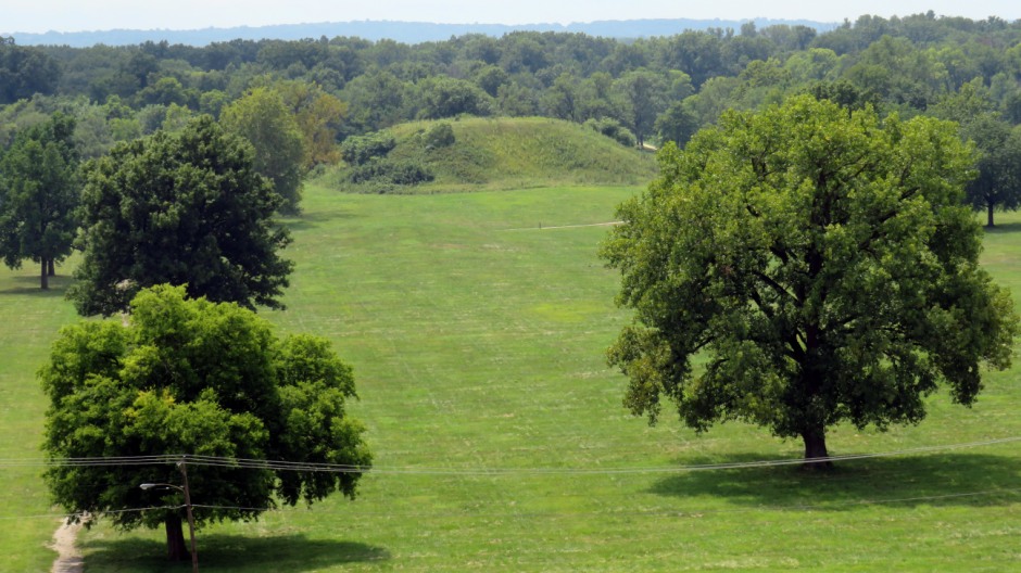
Above: General view of site from Monks Mound, the largest of the mounds at Cahokia [Composite image, perspective stitch]
The peak of Cahokia’s prosperity and influence occurred from this time, until around 1200 AD, with a population of 10-20,000 people inhabiting an area of six square miles. Cahokia was the largest community north of Mexico. The centrepiece of this prosperous settlement was Monks Mound and the 40-acre Grand Plaza, where public events took place. Most of the Grand Plaza appears to have been artificially filled and levelled. By around 1200 AD, the population of Cahokia began to decline and what were ceremonial areas became turned over to residential areas, although the location continued to serve as a major ceremonial centre. By the time of the mid-1300’s, the settlement was by and large in a state of abandonment. It remains a mystery where the Cahokians went or what tribes they then became. Possible reasons for the decline of Cahokia include changes in political or economic power, a reduction in resources, changes to the environment affecting crops and local flora & fauna and/or disease; it is possible that all or a combination of several of these played a role.
The Mounds
The mounds were constructed using stone and wood tools to dig earth from "borrow pits", many of which can still be seen today. The earth was moved in baskets on people's backs. It is thought that the mound construction alone involved moving some 50 million cubic feet of earth. Many of the mounds were constructed in several stages, the most common being the rectangular platform; this type of mound formed a base to elevate ceremonial buildings and residences of the most important people in the social structure. Other mounds were conical and ridgetop in form; these were often used for burials of important people, or as location markers, although the majority of the people were buried in cemeteries.
Monks Mound
Monks Mound is the largest known prehistoric earthen construction in the whole of Americas. It is the only mound which can be climbed by the visitor here today and offers a fine view of the site (as well as distant views towards downtown St. Louis) from its top which rises some 100 feet from its base. This mound contains an estimated 22 million cubic feet of earth and the base has an area of over 14 acres. Originally, a large building would have stood on the summit of the mound and this is where the principal chief would have lived, conducting ceremonies, and government business. The mound derived its modern name from French Trappist monks who lived on a nearby mound from 1809-1813, and farmed its terraces.
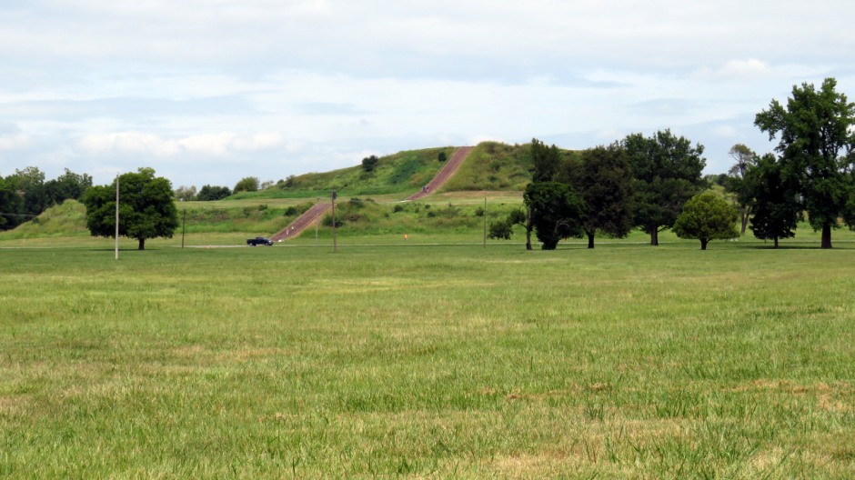
Above: Monks Mound
Mound 72
Excavations of this small ridgetop mound have revealed nearly 300 ceremonial burials, mostly of young women, in mass graves. Of particular note here, was the discovery of an elite male, of around 45 years of age, whom was laid on a platform of 20,000 marine shell disc beads formed in the shape of a raptor bird. Close by were other burials and a large find of grave offerings. Three small mounds covered these burial groupings and a final cap of earth joined them to form this ridgetop mound.
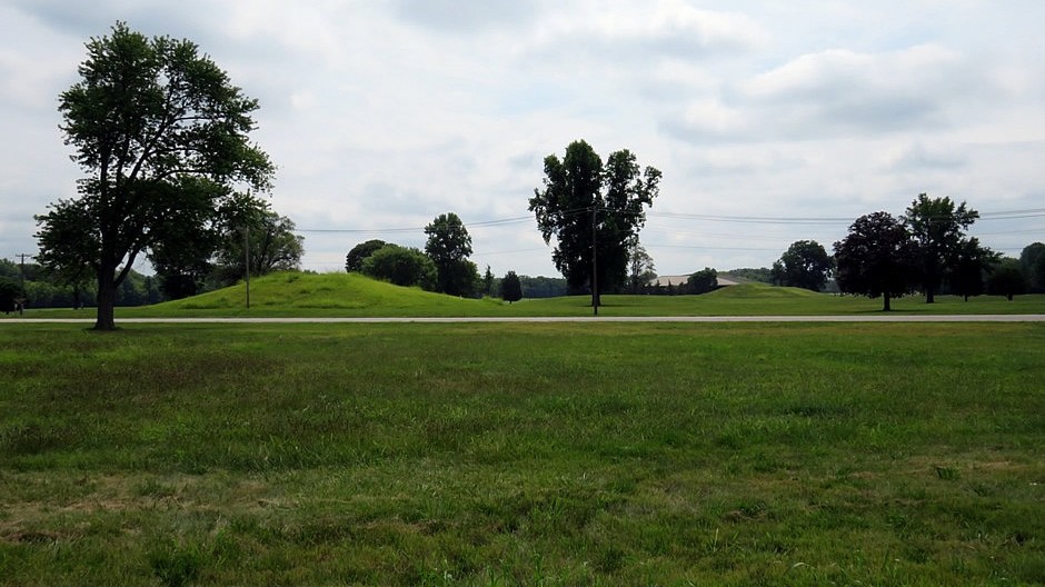
Above: Mound 72 lies in woodland, beyond the large mound shown here, towards the very southern end of Cahokia State Historic Site (time did not permit a walk around the full site; the marked trails include one of ten miles in length!)
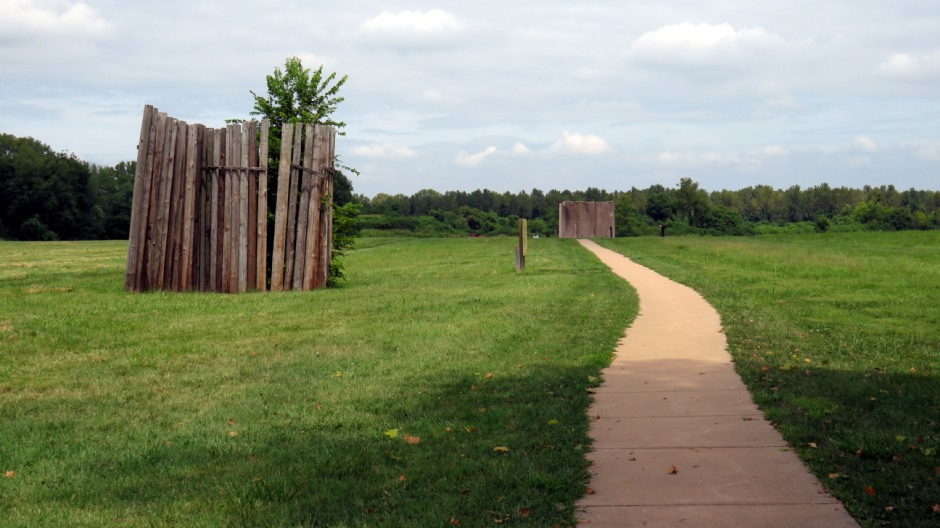
The Stockade
The Stockade runs around the central ceremonial precinct for nearly 2 miles and is a defensive log wall which also served as a social barrier, segregating the more sacred precinct and the elite who lived within it. Also known as the Palisade, guard towers stood along the wall at regular intervals. Evidence shows the wall was built four times, each new wall replacing an old decaying one. Each wall would have required an estimated 20,000 logs. In terms of the Stockade’s role in defending Cahokia, the enemy is unknown, but between 1175-1275 AD, when it was replaced several times, there appears to have clearly been a threat from outside, perceived or real.
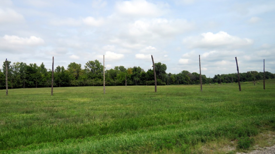
Woodhenge
At Cahokia, archaeological work has partially uncovered five circular sun calendars called Woodhenges. Constructed in 1100-1200 AD, these were used to determine the changing seasons and ceremonial dates. Each ‘Woodhenge’ was different in size and made from a number of large, evenly spaced red cedar posts. These sun calendars represent a fine example of science and engineering knowledge that the Mississippian society possessed. Today stands a reconstructed Woodhenge, representing the third construction and a large central observation post. Key posts in the construction align with the sun, as it rises during the Winter and Summer Solstices and the Spring and Autumnal (Fall) equinoxes. Like Stonehenge in England, people gather here for observances around these times of year.
Houses and Structures
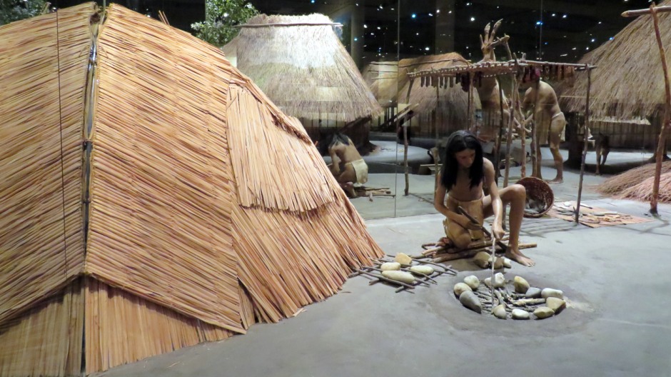
The buildings at Cahokia were constructed using poles and thatch. Walls were covered with layers of woven mats or saplings entwined around the poles; these were plastered with a mixture of clay and grass. Roofs were made from bundles of thatched prairie grass. Most of the houses would have provided accommodation for single families. Other buildings would have been used for community purposes or the storage of grain. The structures atop the mounds were either ceremonial or residences of important people. Small circular structures seen at eh site appear to have been sweat lodges – used to perform purification ceremonies, known simply as a ‘sweat’.
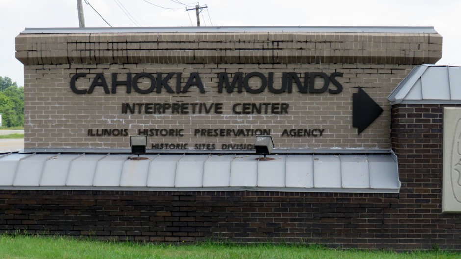
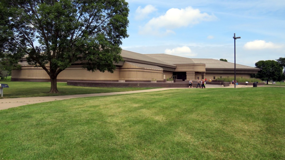
The Visitors Centre
The Visitors Centre (or Interpretive Center) makes for a good starting point for any visit to provides an excellent overview to the Cahokia Mounds. Funded by the State of Illinois, the building opened in 1989 at a cost of $8.2 million.
The main lobby area contains, amongst other features, a site model and not to be missed is the 17 minute “City of the Sun” introductory show, which runs every half hour throughout the day in the theatre to the left, as seen after entering the main entrance. The Interpretive Center Gallery features various wall murals which depict the site at its peak around 1150 AD. Also on show here are awards received by the Interpretive Center and the Historic Site, a 22-foot long dugout canoe dating from 1310-1450 AD and a life-sized Village Diorama depicting life as it was around the year 1200 AD, reflected into the distance by mirrored walls. The extensive Exhibition area of the Interpretive Center is separated into different themes arranged as ‘Islands’. These include the following:
Time – An exhibit explaining the physical settings of Cahokia, previous
cultures, what was going on in the rest of the world and trade.
Culture
– All about Mississippian communities and their social organisation.
Wetlands & Waterways – A 52-foot diorama exhibit showing the culture and
trade that resulted from the Mississippian’s use of their environment.
City – An explanation of Monks Mound and what made Cahokia a city.
Structures – This exhibit explains how the mounds were built, the
different dwellings and other buildings, Woodhenge (the solar calendar)
and the Stockade Wall.
Life – An explanation of the seasonal activities
which took place here, relating to food, games, beliefs and the social
classes, and Mound 72.
Products – This ‘Island’ exhibit looks at the
various stone tools which were made, the various uses of wood, pottery
production, weaving and how objects were crafted from shell.
Knowing –
This exhibit looks at the process of archaeology and how it helps us
gain a modern understanding of the past.
Conclusion – This exhibit
contains a panel explaining when and why the city was abandoned and what
happened to the Mississippian people.
After the Mississippians – A
timeline here features photos and artefacts depicting life here from the
1350’s right through to the modern era.
The Interpretive Center includes information on tours and trails around the site, a café, shop and a very helpful Information Desk. Opening hours are generally 9am-5pm, although days vary. For more information, click on the link Here. The thumbnail gallery below contains photos taken from a walk around the Interpretive Center.
References and Further Information
1.
In-Situ Information Boards
2. Mink, C. and Iseminger, W. (n.d.).
Cahokia, city of the sun. Cahokia Mounds State Historic Site on the
UNESCO website
Here
3. International dictionary of historic places.
(1995). Chicago: Fitzroy Dearborn.
4. Cahokia on Wikipedia
Here
Back to Top