Yerevan is the capital city of Armenia and with a population of just over a million, the largest. Archaeological evidence has shown it to be one of the most ancient cities in the world. It sits at an average height of 3,248ft (nearly 1km) above sea level. Yerevan is on the Hrazdan River, northeast of the Ararat plain and its upper part is surrounded by mountains on three sides. The city serves as the cultural, economic and political centre of Armenia and has plenty to offer the visitor.
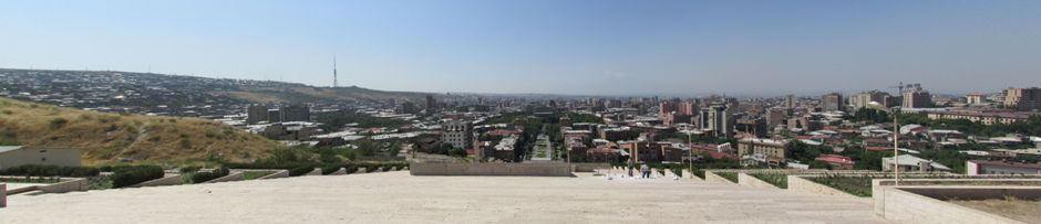
Yerevan panoramic stitch, as seen from The Cascade
Yerevan's recorded history goes back to the founding of the fortress of Erebuni in 782 BC by King Argishti I of Urartu. It's long history includes a period of Iranian rule from the early 16th century until the 19th century when it was taken over by Imperial Russia as a result of the Russo-Persian War (1826-1828). After World War I, the city became the capital of the First Republic of Armenia. This was short lived, as in 1920 the Red Soviet Army invaded Armenia which then became a Soviet Socialist Republic. Under Soviet rule, the city underwent an extensive plan of redesign, which involved the demolition of many historic buildings and the construction of new institutions. The plan, approved in 1924, included a radial-circular arrangement of roads overlaying the existing street plan - a layout seen today. With the dismantling of the USSR as a result of the Gorbachev era of the 1980's, in 1991 Yerevan once again became the capital of Armenia. Although in its infancy, the modern Republic of Armenia suffered much economic hardship, the growth of the country since the early 2000's has meant Yerevan has more recently been undergoing many modern transformations.
The main symbol of the city (and of Armenia) is Mount Ararat, which is visible across the city when the air quality and weather permits. For a closer look at Mount Ararat, see my webpage on Khor Virap and Mount Ararat Here. Depending on the visitors' tastes, there is plenty to do and see including museums, galleries, institutions, religious buildings, parks, shopping and so forth. The city boasts an astonishing array of sculptures, monuments and statues, the latter being highlighted on Wikipedia Here. Descriptive text of some of the sights in the city follows the photo gallery below.
The following text is not meant as a comprehensive guide to the sights the city has to offer, but more as a description of what was seen on my particular visit: The main street in the city is Mashtots Avenue [Photo 1] which runs from Victory Bridge in the southwest of the city centre to the Matenadaran, northeast of the city centre. The Matenadaran is a repository of ancient manuscripts and is seen as a rectangular shaped building at the end of the avenue in the photo. Mashtots Avenue intersects with many streets in the city centre including those running perpendicular to it and the previously mentioned radial-circular streets. As well as shops and cafes, many sights are to be found along it including the Blue Mosque, museums, parks, theatres and the Opera house. Between 1924 and 1990, Mashtots Avenue was known as Lenin Avenue. Today, the avenue is named after Mesrob Mashtots a 5th Century scholar and monk (and later a saint) who invented the Armenian Alphabet. His work set in motion an explosion in education, literature and the arts for the Armenian people. A couple of photos towards the end of the gallery show Mashtots Avenue from afar [Photos 89 & 90].
One of the main sights in Yerevan (and a personal favourite) is The Cascade - a giant stairway linking the central area with Haghtanak Park (see below). The Cascade and views of the city from various levels of the stairway are shown in the gallery above [Photos 2-42]. At the base of The Cascade is Tamanian Park and it is here stands a statue of Alexander Tamanian [Photo 3], whom in the 1920's designed the city's plan of circular avenues, ring roads and parks. The statue shows him studying the original plans. A series of fountains and sculptures are to be found here, several of the latter appearing to relate to Alice's Adventures in Wonderland. From here, The Cascade steps rise up 100m and over a length of 500m. In addition to the steps, The Cascade has a series of levels with outer courtyards containing fountains, flowerbeds and sculptures. Inside The Cascade are a series of escalators which run its entire length (which, whilst walking up outside in 36°C, I was ignorantly unaware of!). Construction of The Cascade began in 1971 with phase I completed in 1980. With a width of 50m, the giant monument remained incomplete for many years until a wealthy donor (American-Armenian businessman Gerard L. Cafesjian (1925 - 2013)) was found to continue the work which began in 2002. The completion of The Cascade is part of a project which includes The Cafesjian Museum of Art, constructed to house his extensive private collection of modern art - a collection which several world leading art galleries attempted to obtain.
Photos 45-47 are of the Armenian Genocide Memorial Complex. I have included some text and more photos of the complex on a separate webpage Here.
One of the countless monuments in the city is the Monument to Komitas [Photo 51]. Soghomon Soghomonian (1869 - 1935), ordained and popularly known as Komitas, was an Armenian churchman, composer and musician who is revered in Armenia. He wrote over three thousand songs in Armenian, Arabic, Kurdish, and Persian and is considered the founder of the Armenian national school of music. His folk based work recognized him as one of the pioneers of ethnomusicology. Further reading Here.
The Opera House on Freedom Square [Photo 52] may be considered the true centre of the city. Located not too far from the bottom of The Cascade and Tamanian Park, it is the point at which the major streets in the city, including Mashtots Avenue, intersect. Heading south from the opera house is Northern Avenue [Photos 53-57], a pedestrian avenue which opened in 2007. Originally planned by the aforementioned Alexander Tamanian in 1924, it was never put in place under the Soviet's and after Armenian independence, the Yerevan City Council decided to resurrect the plan, (literally) paving the way for a new avenue of high class residential buildings, shops, cafes and offices. Construction of Northern Avenue started in 2002 and the project was very controversial - residents of an old neighbourhood in the heart of the city were evicted with little or no payments and unable to afford housing elsewhere in the city. Some say the new buildings are cursed.
Walking on southwards from Northern Avenue and briefly on to Abovian Street takes you to another of the main sites in Yerevan - Republic Square [Photos 59 - 65]. Republic Square was part of Tamanian's general plan of 1924,m with construction starting in 1926. Phase I was completed in 1929 with further development up until 1952. Republic Square was finally completed in 1958. The Finance Ministry building is the only one of Tamanian's own design to be found here. The square is reserved for government offices (e.g. Government House), major museums, the National Gallery and the main Post Office. The buildings are constructed of rose and white Armenian tufa stone. Some hotels are also located off the square. It is here that official celebrations take place (e.g. Independence Day). During the Soviet Period (unsurprisingly) the square was known as Lenin square; a statue of Vladimir Lenin stood from 1940 until it was dismantled in 1990 just before Armenia's return to independence. The square has a stone pattern on the ground which looks like a traditional Armenian rug from above although this is not always quite apparent at ground level; it represents the hospitality of the Armenian people. Also of note are a large clock and dancing fountains. Moving south from Republic Square and crossing Khanjian Street (part of one of the circular roads), The Cathedral of Yerevan is to be found [Shown Primarily in Photos 67 - 76]. The Cathedral of Yerevan, or more specifically, Saint Gregory the Illuminator Cathedral, is a new addition to the city's skyline and the first major post-Soviet building in the city. The cathedral's consecration was timed to mark the 2001 anniversary marking 1700 years of Christianity as the state religion of Armenia. Pope John Paul II paid a visit here shortly after the consecration. Constructed to house 1700 worshippers, it the largest cathedral of the Armenian Apostolic Church in the world. and houses the relics of Saint Gregory the Illuminator and the Holy Remains of St. Gregory.
Further away from the city centre to the south lies Yerevan Railway Station [Photos 77-81]. Yerevan has a single central train station which also connects to the city's metro system. The building is unmistakeably Soviet in style. Outside the front of the station stands a statue of David of Sasun, the main hero of Armenia's national epic Daredevils of Sassoun, who drove Arab invaders out of the country. Just to the north of the city centre and located at the top of The Cascade is Haghtanak Park (Victory Park) [Photos 83-94]. The park is named Victory Park in commemoration of Soviet Armenia's participation in the second World War. From here, one can get stunning panoramic views of the city, whilst taking a break from the busy traffic and crowds of the centre. In the forested park stands Mother Armenia (Mayr Hayastan), a giant statue of an Armenian mother overlooking the city. Around the base of the statue are various pieces of military hardware on display and underneath it, a Museum of the Ministry of Defence. Also in the park are an amusement park and cafes.
Further Reading:
Culture Smart! Armenia by Susan Solomon, Published by Kuperard, 2010
An Armenian Wiki Encyclopaedia at http://www.armeniapedia.org/wiki/Main_Page
Yerevan Municipality Official Website at https://www.yerevan.am/en/tourism/
Back to Top