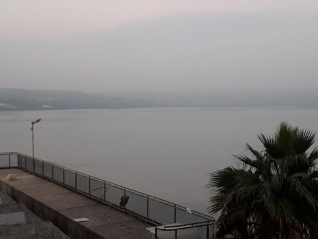
Sea of Galilee (Lake Tiberias)
Known these days as Lake Tiberias, the Sea of Galilee is actually a freshwater lake, located in north-eastern Israel. The River Jordan flows through its length in a roughly northern to southerly direction over some 14 miles (23km), whilst the lake’s width reaches its maximum of some 8 miles (13km) near its northern end. Covering some 64 square miles (66km²), the maximum depth of the Sea of Galilee is approximately 150 feet (46m), whilst the surface is some 680 feet (207m) below the level of the Mediterranean Sea; the River Jordan then flows on to the Dead Sea, which is even lower with respect to sea level, with its shores marking the lowest land elevation than anywhere else on Earth. Geologically speaking, the sea bed of the Sea of Galilee forms a part of the Great Rift Valley.
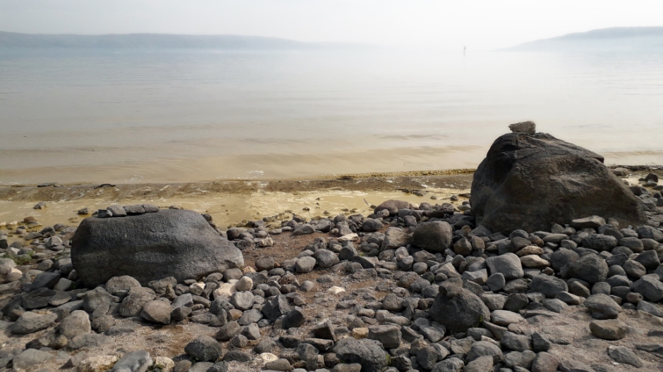
The cool, clear water of the Sea of Galilee are home to several fish, some of which are caught on a commercial scale, various species of bird (such as pelicans, grebes and gulls), tortoises, turtles and various Crustacea. The history of people living here goes back to ancient times and the lake formed the junction of several major trade routes. With an extensive fishing industry, no less than nine cities were to be found around its waters. On the Western shore can be found the city of Tiberias, which is the only remaining town which dated from biblical times. The Sea of Galilee is strongly associated with the life and times of Jesus Christ, as well as his disciples. Jesus came here from Nazareth to live (Nazareth page Here) and it is consequently where he took up ministry, as a preacher. The sites described below on this webpage are largely connected with this particular aspect of this infamous lake.
Ancient Galilee Boat
The Ancient Galilee Boat (otherwise known as the Jesus Boat or Sea of Galilee Boat) is an exhibit on display in a specially designed climatised room as part of a museum (Yigal Allon Galilee Boat Museum in Kibbutz Ginosar) located on the north-western shores of the lake. The boat is an ancient fishing boat, constructed somewhere around the first century AD, making it the seventh-oldest surviving ship in the world. It was discovered in 1986 by two local fishermen brothers, Moshe and Yuval Lufan, who were keen amateur archaeologists. They had always dreamed of finding an ancient boat in the Sea of Galilee and that dream was realised during a time when drought reduced the water-level of the lake; they monitored the newly exposed beach and came across this remarkable discovery buried in the shore. They reported their find to the authorities and upon the realisation that their find was of tremendous historical value to both Jews and Christians alike, an archaeological dig followed, led by the Israel Antiquities Authority. Over 12 days and nights, a careful excavation was made; one which had to be both rapid (to protect it from exposure to the atmosphere and before the water level rose again) and careful (to protect the fragile remains from damage). The boat was submerged in a chemical bath for 10 years, a process for ensuring its preservation, until it could be put on display in the specially designed exhibition room.
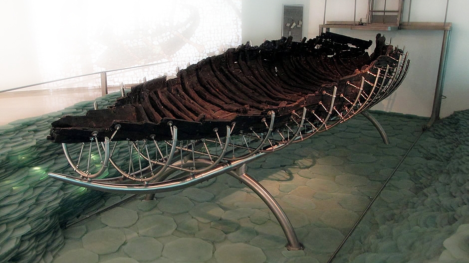
Above: The Ancient Galilee Boat on display at the Yigal Allon Galilee Boat Museum in Kibbutz Ginosar
The preserved remains of the boat measure some 27 feet (8.27m) long, up to 7½ feet (2.3m) wide, and a maximum height of around 4⅓ (1.3m). Its construction is of the same design to other boats which were constructed in the eastern Mediterranean at around the same time. The design is one of shallow draft with a flat bottom, to enable it to stay floating and allow fishing when close to the shore and it would have been able to have had up to four oars for rowing and also a mast for sailing. The construction was mostly made using cedar planks, although the use of multiple wood-types suggests either a shortage of wood at the time that it was constructed out of scrap wood, or that it had been repaired several times. The wood was joined together by pegged mortise and tenon joints and nails.
Dating of the boat was by radiocarbon dating, which put it at 40BC ± 80 years, and estimates based on pottery found at the site and other evidence puts it at 50 BC to AD 50. The vessel may have been used for several decades, perhaps longer, until thought to be beyond repair. It would have been sunk and then mud would have covered it, resulting in it being naturally preserved until its discovery and subsequent excavation. The boat is historically important for Jews as it shows an example of the type of boat their ancestors would have used for fishing and transportation across the lake in the 1st century. It is also important to Christians as it represents the type of boat which may have been used by Jesus and his disciples who were living in the area at the time; several of Jesus’ disciples were fishermen. However, there is no actual evidence connecting the boat to Jesus or his disciples. Some more photos taken from the outside and interior of the museum are shown in the photo gallery below [click on an image to enlarge]:
Tabgha
On the north-western side of the Sea of Galilee lies Tabgha, an area which is traditionally thought to be the site where Jesus is said to have performed his miracle known as the multiplication of the loaves and fishes (Mark 6:30-46) and his fourth resurrection appearance (John 21:1-24) after being crucified. The name Tabgha translates as "spring of seven"). Two churches can be found here, namely The Church of the Multiplication of the Loaves and Fish and the Church of the Primacy of Saint Peter, described below respectively.
Church of the Multiplication of the Loaves and Fish
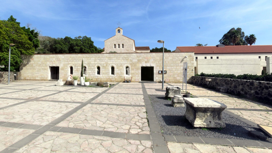
The Church of the Multiplication of the Loaves and Fish is a Roman Catholic church located on the edge of the lake. Looked after by a German Benedictine Order, this modern church, dating from 1982, stands on the site of an earlier 4th century Byzantine church commemorating Jesus' feeding of the five thousand. This church, in turn, was significantly enlarged around the year 480, with floor mosaics also being added. In AD 614 Persians destroyed the Byzantine church. Following this, the exact site of the shrine was lost for some 1,300 years. However, in 1888, the site was acquired by the German Catholic Society for Palestine which was associated with the Archdiocese of Cologne. Archaeological excavations from 1892 onwards led to the discovery of mosaic floors from the 5th-century church atop the foundations of the smaller 4th-century chapel. The Germans erected a provisional protective structure over the site and subsequently the church seen today, inaugurated in 1984, was built here to the same floor plan as the 5th-century Byzantine structure. Parts of it (though not the church building, itself) were badly damaged during the summer of 2015 when right-wing Jewish extremists committed an act of arson on the property. For the visitor, of note here is a block of limestone rock under the altar, found during excavations, which is believed by some to be the “solitary place” upon which Jesus is said to have laid the five loaves and two fishes when he performed his miracle that multiplied them to feed five thousand faithful listeners. Also here, it is possible to see the restored 5th-century mosaics, which are the earliest known examples of figurative Christian art floor mosaics anywhere in the Holy Land. Photographs from the visit here may be seen in the thumbnail gallery below [click on an image to enlarge]:
Church of the Primacy of Saint Peter
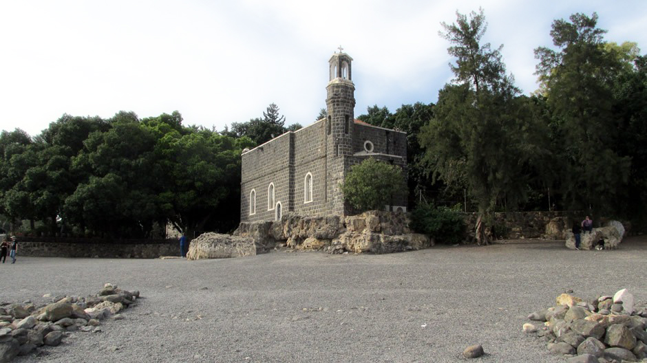
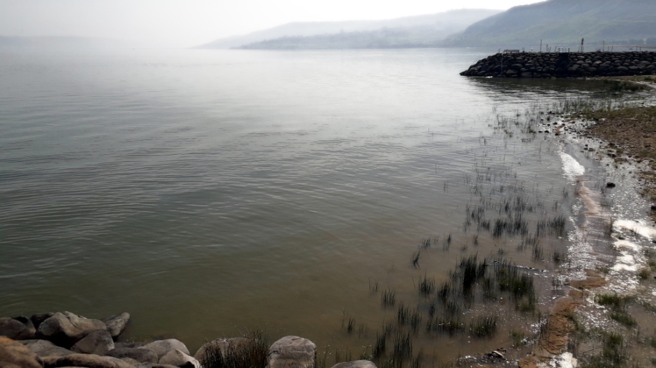
Just a few hundred yards east of the Church of the Multiplication of the Loaves and Fish is sited the Franciscan Church of the Primacy of Saint Peter. Accessed on foot from the road down a shady garden, the church is situated on the edge of the Sea of Galilee, although a lowering of the level of the lake in more recent times has meant the photos taken here show the water’s edge somewhat further away from the base of the building than perhaps can be seen in pictures taken in earlier years. The church is actually a chapel and is lit inside by the sunlight by the vivid colours of abstract stained glass. It was built in 1933, incorporating parts of an earlier 4th century church, and commemorates (and allegedly marks the spot of) Jesus' reinstatement of Peter as chief among the Apostles. With various elements of the earlier structure still visible today, the original building survived longer than any other in the area, finally being destroyed in 1263. In front of the present altar is a somewhat disputed location known to Byzantine pilgrims as Mensa Christi (Christ’s Table) – a projecting flat limestone rock which is believed by some to be the spot where Jesus and his disciples breakfasted on fish, and where he told Peter to "Feed my sheep" after the miraculous catch. On the side of the church which faces the lake, some steps cut out of the rock are believed by some to be where Jesus stood when his disciples saw him after his resurrection. The possibility does remain, though, that the ‘steps’ were created in the 2nd or 3rd centuries when the area was quarried for limestone. The church was visited by Popes Paul VI in 1964 and John Paul II in 2000 during their visits to Israel. Not surprising, due to its significance to the Catholic Church. Photographs from the visit here may be seen in the thumbnail gallery below [click on an image to enlarge]:
Just under a couple of miles eastwards from Tabgha along the shores of the Sea of Galilee is located the ancient town of Capernaum. This historical Palestinian settlement contains a continuously spread out collection of ruins and is open to visitors. In various states of decline and resettlement, the town is believed to have been continuously inhabited since its beginnings in the 2nd century BC, during the Hasmonean period, right through until the 11th century AD, when it was abandoned (sometime before the Crusader conquest). Ruins at this location (at the village of Tell Hum) were discovered in 1838 and excavations began in 1905 and these identified the location of the site of Capernaum, the place where many events took place in the Galilean ministry of Jesus Christ, as described in in all four Gospels (Matthew, Mark, Luke and John). Jesus’ first disciples, Andrew, Matthew, and Peter are thought to have lived here.
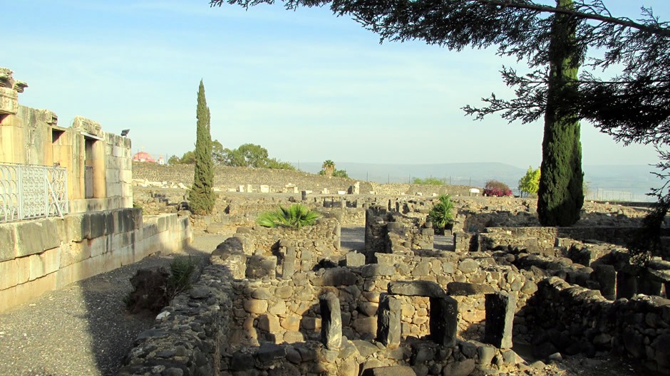
Amongst the ruins in the town are a couple of synagogues; one dating from around the 2nd-4th centuries AD (partly restored and used as a monastery by Franciscan monks) and one dating from the 1st century AD. Significantly, Capernaum - a fish-market and frontier post beside the Sea of Galilee, became the home of Jesus and the location of many of the miracles he is said to have performed. Jesus worshipped and taught in the synagogue here, where his authoritative teachings made a significant impression on the locals. In the same synagogue, according to the Book of John, Jesus promised the Eucharist in his “I am the bread of life” discourse (“Very truly, I tell you, unless you eat the flesh of the Son of Man and drink his blood, you have no life in you.”). He is said to have healed many people in the town, although he also pronounced a curse on it, alongside nearby settlements because many of the inhabitants refused to believe in him.
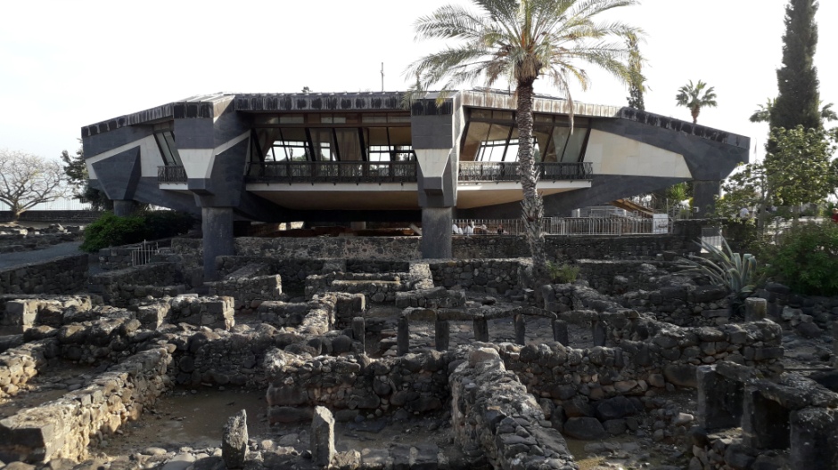
In March 2000, John Paul II visited the site during his visit to Israel. One of the most striking features atop the ruins which face the visitor is the presence of a modern Catholic church, which was dedicated in 1990 and is perched on eight sturdy pillars above the excavation site. It is positioned above what is thought to have been the site of Peter’s house, where Jesus would have lodged. The house was an interlinked complex grouped around courtyards. One of the rooms has been identified and venerated as early as the middle of the 1st century as being used for religious gatherings as a house church. In the 5th century, an octagonal church was built around this room. The modern church on the site today follows the same octagonal shape. Near here is a partly reconstructed synagogue believed to be on the site of the synagogue in which Jesus taught. Not far away from Capernaum, by the Sea of Galilee, can also be seen a Greek Orthodox Church which was built in 1931. Dedicated to the Twelve Apostles, it has distinctive red domes and white walls. Some more photos from the web page author’s phone and camera of the site at Capernaum can be seen in the thumbnail gallery below [click on an image to enlarge]:
Mount of the Beatitudes
Overlooking Tabgha and Capernaum, the Mount of Beatitudes rises approximately 155m (509 feet) above the surface of the Sea of Galilee (with a highest point of 58m/190 feet). Also known as Mount Eremos, it was identified by the Byzantines as the location of the Sermon on the Mount, a famous oratory by Jesus, described in the Gospel of Matthew (the first Book of the New Testament of the Bible), in which he put weight on his moral teachings. Although the actual location of the Sermon on the Mount is not certain, based on Biblical clues and the regional topography, a large relatively flat and open steppe on the hillside is generally accepted as the correct location and it has been considered so for over 1600 years. The location is inspirational, offering a spectacular view over the Sea of Galilee below.
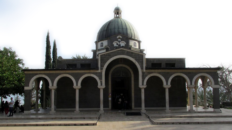
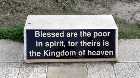
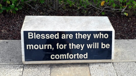
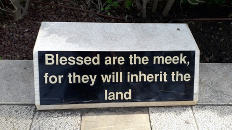
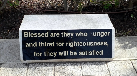
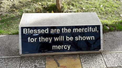
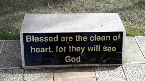
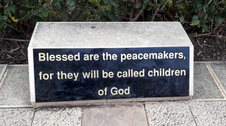
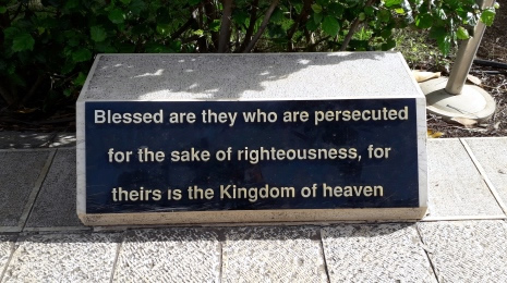
Atop the Mount of Beatitudes, a little less than a mile north of Tabgha, stands the Church of the Beatitudes. The church is relatively modern, dating back to the 1930’s. It was built in part by finances from Italian dictator Benito Mussolini. The landscaping around the church and its setting are probably the most inspiring feature here; the building, itself, is a relatively small and modern structure, constructed in an octagonal design, symbolising the eight Beatitudes. Each of these beatitudes (blessings) which were given by Jesus during his Sermon on the Mount are displayed on small stone plinths along the path leading up to the Church of the Beatitudes:
 |
 |
|
 |
 |
|
 |
 |
|
 |
 |
As seen in the thumbnail gallery below, which shows photographs taken during the visit in 2018, recitations of the Sermon on the Mount are a common sight; these can be heard both outside and inside the church. [Click on an image to enlarge]:
Tiberias
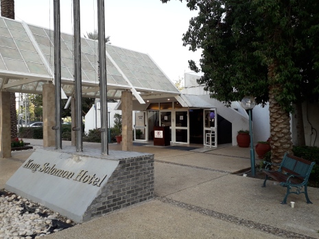
During the visit to the Sea of Galilee (LakeTiberias) featured on this webpage, a one-night stopover was made in the city of the lake’s namesake, Tiberias (Teverya, in Hebrew). The city is situated on the shores of Galilee and as well as being a lake port, is not short of hotels as it also serves as a popular resort town. With a population of roughly thirty six thousand, Tiberias is approximately 682 feet (208m) below sea level. It was named after the Roman emperor Tiberius and built around AD20 by Herod Antipas; ruins of the baths he built are still in existence today. Tiberias is one of four holy cities of Judaism and a popular base for Christians visiting the holy sites around the Sea of Galilee. As well as various “non-touristy” industries, including fisheries, textile factories and machine workshops, as a resort, Tiberias boasts some 17 hot springs, beaches, a lakefront promenade and various sites, including the Tiberias Open Air Museum, The Church of St Peter and the Church and Monastery of the Apostles, a theatre showing the “Galilee Experience” film, the 18th century Al-Bahr Mosque, various tombs of Jewish Sages and also around here, the Hamat Tveriya National Park and the Al-Amari Mosque. On a historical note, in 1260, during the Battle of EinJalut, the Mongols came to the area and suffered their first ever defeat in history, resulting in their expansion into the Middle East coming to an abrupt end.
 |
 |
Above: The King Solomon Hotel in Tiberias - one of many the city has to offer with balcony views of the Sea of Galilee
[Photos: February 2018, Text: 2018]
Related Pages on this Web Site:
Bethlehem
Dead Sea
Golan Heights and Mount Bental
Jerusalem
Nazareth
Back to Top