Mount Faber and Telok Blangah Hill Park
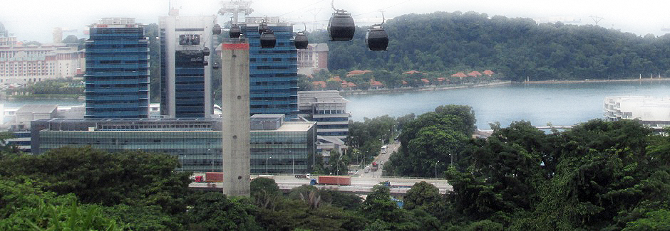
Above: Cable Cars run up to Mount Faber from HarbourFront Tower 2, and Sentosa Island (seen here, behind the towers).
On the southern tip of Singapore Island from where Harbourfront is locates runs the Southern Ridges. Along the ridge running north and westwards are a series of parks which include Mount Faber Park, Telok Blangah Hill Park and Kent Ridge Park. In 2002, Singapore's Urban Redevelopment Authority came up with the idea of linking these parks via a continuous trail and the result two years later was the completion of the Southern Ridges, a series of trails connecting the parks together between Kent Ridge Park and Harbourfront. Not only are the paths of these trails well laid out and offer stunning views, but also incorporate some spectacular new bridges which were constructed to ensure the continuity of the walk along it's entirety.
Please note: Main Singapore Web Page Here
Map Courtesy of Openstreetmap
Starting at the Harbourfront end, the walk comprises Marang Trail (800m) which ascends Mount Faber, Faber Walk (1km), the Henderson Waves bridge, Hilltop Walk (1km), Forest Walk (1.3km), the Alexandra Arch bridge, Floral Walk (300m), Canopy Walk (150m) and the Kent Ridge Trail (9km). (the official start to end of the Southern Ridges runs in a counter direction). In addition to the new trail, a number of ecological projects have been put in place at Southern Ridges which include the establishment of trees that attract native birds.
The photographs in the thumbnail gallery below are from a walk which started at the top of Mount Faber. For those not used to walking up hills in Singapore's climate, although it is possible to take a cable car from Harbourfront (as well as Sentosa Island), a less spectacular but also considerably cheaper option we found here was to take a taxi ride from Harbourfront up to the Mount Faber Cable Car Station. Our walk then took us from here, along the Faber Walk, crossing the Henderson Waves bridge, along the Hilltop and Forest Walks of Telok Blangah Hill Park and finishing at the Alexandra Arch bridge. Departing from the Southern Ridge at this point, a short walk was then taken to view The Interlace, an unusual housing construction, from an architectural point of view.
The Faber Walk (Photos 1-25, above) takes the visitor through one of the oldest parks in Singapore. At 106m (348 feet), Mount Faber is one of the highest hills in Singapore. It overlooks the Telok Blangah area and the western parts of the city’s Central Area. The hill was originally known as Telok Blangah Hill, but later renamed after Captain Charles Edward Faber of the Madras Engineers. He arrived in Singapore in 1844 and his work enabled the construction of a road to the top of the hill to take place. In 1845, a signal station was erected on the hill. Defence work was carried out on the hill after the Indian Mutiny of 1857 and just after the turn of the century, an observatory was built here (in 1905). The Faber Walk is set amongst secondary rainforest and the main attraction seen on this particular walk was Faber Point, where panoramic views extend towards the central business district, Harbourfront, Sentosa Island and towards islands in the distance which belong to Indonesia. At Faber Point stands one of 5 official Merlion Statues (see main Singapore page for more about the Merlion, below photos, Here). Other attractions in Mount Faber Park include Marina Deck, Palm Plaza and Jewel Box.
Leaving Faber Park, the walk then crosses over Henderson Waves (Photos 26, 30-40, above). This is a 274m (899 foot) long footbridge which at 36, (118 feet) above Henderson Road is the highest pedestrianised bridge in Singapore. Connecting with Telok Blangah Hill Park, the modern construction is formed from seven undulating curved steel ribs giving a wave-like appearance. The steel ribs rise above the deck forming alcoves that serve as seated shelters. The bridge is lit up at night-time with an array of LED lamps. Below is a panoramic stitch of photographs taken from Henderson Waves.
Our walk continues along the Hilltop and Forest Walks of Telok Blangah Hill Park (Photos 42-67, above). Telok Blangah Hill Park covers 34 hectares and was once a gathering place for trading communities that flourished in the area in the early 19th century. It is a popular place for wedding couples, exercising and picnics, and the park's Terrace Garden features a 360° view of the city. The Forest Walk comprises a spectacular 1.3km steps-free elevated walkway meandering through the secondary rainforest of Telok Blangah Hill. The walkway stands between 3 and 18m above the ground, brushing with the canopy of trees, giving a birds eye view of the vegetation. There are also a series of ground level earth trails which give the visitor a more close-up chance to see the park's wildlife.
The Forest walkway gradually descends down towards Alexandra Arch (Photos 69 & 74, above), an 80m (260 foot) long bridge, which features a curved deck and tilted arch, giving the appearance of an opened leaf as it stands over Alexandra Road. As previously mentioned, from Alexandra Arch, it is then possible to continue along the Southern Ridges on through Kent Ridge Park; the walk finally ends (or in the official direction, starts) at a car park adjacent to the city's West Coast Park.
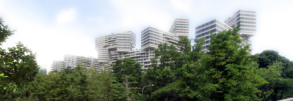
It is from Alexandra Arch, the walk featured on this webpage departed from the Southern Ridges to take a look at The Interlace (Above and Photos 62, 63, 72, 73, & 75-79 in the thumbnail gallery). Named World Building of the Year at the 2015 World Architecture Festival, The Interlace is a building complex housing 1,040 apartment units of varying sizes. Designed by Ole Scheeren, partner of OMA, it adopted a new residential typology, breaking away from the standard isolated, vertical apartment blocks typically found across the city. 31 blocks, each of 6 storeys and identical in length are stacked in a hexagonal arrangement to form 8 large open interconnecting courtyards. The stacked formations allow light and air to flow through the complex and help provide a more harmonious integration with the surrounding natural greenbelt environment. The complex is not open to the public, with gated access by permission only.
References and Further Reading:
1. Singapore Island & City Map. Periplus Travel Maps. 2014. Print.
2. In Situ Public Information Boards.
3. Bonetto, Cristian. Singapore. Footscray, Vic.: Lonely Planet, 2015. Print.
4. Frost, Mark Ravinder and Yu-Mei Balasingamchow. Singapore. Singapore: Editions Didier Millet, 2009. Print.
5. Lim, Richard. Rough Guide To Singapore. Rough Guides, 2016. Print.
6. Article on The Interlace from Business Insider Here (External Link).
Back to Top