Guernsey is the second largest of the Channel Islands. It lies 30 miles (48km) west of Normandy, France. Alongside other islands including Alderney, Sark and Herm, it forms the Bailiwick of Guernsey, a Crown dependency. It is not in the European Union, but has a special relationship and has access to the single market. It is in the Commonwealth but is self-governed, with its own traditions, taxation, laws, money, Norman-French language and character. Guernsey has a population of approximately 63,000 and it is 25 square miles (65km²) in area. The Island is divided into 10 parishes (Castel, Forest, St Andrews, St Martins, St Peter Port, St Pierre du bois, St Sampson, St Saviour's, Torteval and Vale).
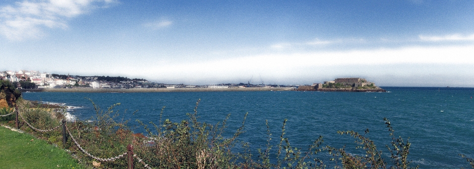
Above: St Peter Port and Castle Cornet
The capital is St. Peter Port, situated on the eastern side of the island, which itself rises in a plateau to about 300 feet (90m), with ragged coastal cliffs. The north of the island is low-lying, with small outcrops of resistant rock forming hills. It has a maritime climate with an annual temperature range of only about 9°C (17°F). Snow and severe frost are rare on the island and a relatively low rainfall means water supplies are supplemented by seawater distillation.
Map: Courtesy of Openstreetmap.org
A brief history of Guernsey follows. Neolithic farmers settled the island's coast and built dolmens and menhirs which can still be seen today. The island was known to the Romans, who called it Sarnia and towards the end of the 4th century, during their migration to Brittany from modern-day Wales and South-Western England, the Britons occupied the island, alongside Jersey. The Channel Islands were part of the Duchy of Brittany until 933AD, when they were annexed by the Duchy of Normandy. In 1066, when William, Duke of Normandy invaded England and became King William I, as His Duchy of Normandy included the Channel Islands, they became part of the realm of England and Normandy. 138 years later under King John, most of the Duchy of Normandy was lost to the English Crown, although Guernsey, alongside the other Channel Islands remained loyal to it. There were subsequent times when the French tried, and failed, to establish rule on Guernsey (and Jersey) and as a result of many raids by them, several fortresses were built around the coast. Over the years, Guernsey developed it's own independent legal system and parliamentary institutions. Today, it is largely a self-governing territory, although local legislation still requires Royal assent. The German's invaded the Channel Islands in July 1940 and occupied them for nearly five years, until May 1945; they were the only British territory to be occupied by the Germans during World War II. Just before the Germans invaded, many of Guernsey's inhabitants were evacuated to England. It is said that the generation of Guernsey people who grew up on the UK mainland at this time, on their return did more to anglicise Guernsey than any other event in their history. During World War II, some 2,000 Guernsey people were imprisoned in Germany. The German Occupation of Guernsey was a time of censorship, restriction of freedoms, isolation and growing shortages. After D-Day, the islands became cut off from the French mainland and the people here came close to starvation so the Liberation in May 1945 was of utmost importance for their survival. The people of Guernsey take pride in the fact that their allegiance today to the English Crown has been through choice and not by force and in a rather bizarre history, it was actually their Duke that invaded England. In terms of the Guernsey military today, as their allegiance is to the British Crown and not the British Government, they have not had to serve in the British Government led conflicts of more recent times.
With the Island's history in mind, it is not surprising to learn that Guernsey's population is mainly of Norman descent, with a mix of Breton. English is one of the official languages and the only dominant language found today on the island. French was the official language until 1948 and is still the language used in administration. A minority of people on the island speak a variety of Norman language known as Guernésiais (Dgèrnésiais). This is the traditional language and similar to the dialect of mainland Normandy. Other varieties of the Norman language spoken in the Bailiwick of Guernsey are Sercquiais (on the island of Sark) and Auregnais (on Alderney). Dairy farming takes place on the island, particularly on the high land on the south of the island and the Guernsey breed of cattle is famous for it's rich flavour of milk that is produced. In the north of the island, the farming is mainly market gardening with greenhouses that produce tomatoes, flowers and grapes. These are mainly exported to England. Since the last century, tourism has become an important industry on the island and whilst it boasts many fine beaches, walks and activities, the following photos and text focuses on some of the main tourist sites on the island. The coverage on these pages is far from comprehensive, but covers a relatively large number of the main highlights. For practicalities on visiting Guernsey, a starting point can be found on the Visit Guernsey website Here.
St Peter Port
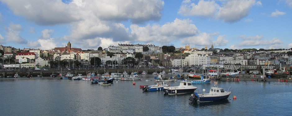
Above: St Peter Port
St Peter Port is the principal town, resort, Parish, and capital of Guernsey. It is the home of the island's government, main harbour, centre of finance and a large amount of housing. St Peter Port can generally be divided into three parts, namely the oldest part centred around the town's ancient Parish church, waterfront and high street, the part sometimes called the 'new town' which is on higher ground above the older medieval area and contains many Georgian and Regency residences and a third part which comprises modern housing estates on the perimeter of the Parish. The latter part contains some expensive properties, owned by tax exiles attracted to the island for this purpose. Photos of the town are shown in the thumbnail gallery below.
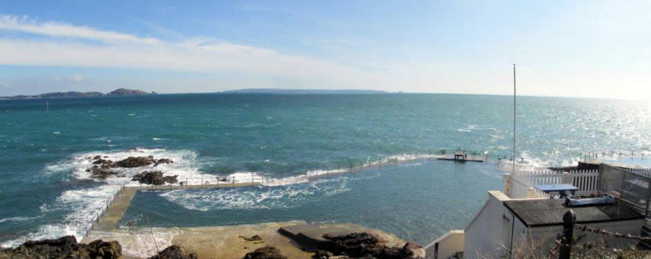
There is plenty to see and do around St Peter Port, whether it is taking in the harbours and marinas or simply exploring the town. One of the main sites is Castle Cornet and this is treated separately below. Since the days when Castle Cornet was built early in the 13th century, the town continued to grow and the present harbour was constructed between 1853 and 1874. By the harbour stands the Liberation Monument [Above, Photos 42, 51,80]. This was constructed to commemorate the 50th anniversary on 9th May 1995 of the Liberation of Guernsey from German Occupying forces. The shopping centre of the town [Photos 72-76] is an attractive area to wander around and many high street names you would find on mainland Britain are here, although the buildings themselves have changed little in hundreds of years. There are plenty of winding cobbled streets and as you wander between streets, some are connected by flights of steps [Example, Photo 18]. It is also around here the visitor will find a fine selection of restaurants, many of which, as one might expect, serve seafood. The seat of Guernsey's government is in The Royal Court House (1799), where the States of Deliberation, the island's parliament, meet each month. The island's courts are also located here. The Town Church [Photo 36] is referred to in a charter of ca. 1048 and the building today maintains a variety of 13th-century styles. One of the most well known houses in the town is Hauteville House [Photo 27]. This is where the French author Victor Hugo resided from 1855 to 1870 and is now a museum. Here he wrote some of his great works, including Les Miserables. The house now belongs to the city of Paris, France. Other buildings of note include the Markets, dating from 1822 [Photo 96], Elizabeth College(1826; founded 1563) [Photo 68], the Constables’ Office, St James Concert and Assembly Hall [Photo 69] and the Priaulx Library [Photo 65]. In the town on Union Street stands a Victorian Pillar Box [Photos 90,91]. The British Post Office installed its earliest roadside posting boxes in the Channel Islands in 1852/3 and this particular pillar box is the oldest survivor still in daily use in the whole of the British Isles. Further up the hill from the town centre stands the Guernsey Museum and Art Gallery which is situated in the beautiful gardens at Candie [Photos 54-64]. The museum tells the story of Guernsey and it's people. There is a range of items here from its early inhabitants, but don't expect displays covering the German Occupation. For that, other sites on the island cover this period of the island's history - some of the main ones are described later on in these pages. Displays in the art gallery are changed frequently and include temporary exhibitions from local artists. The gardens include statues of Victor Hugo [Photo 54] and Queen Victoria [Photo 64] and overlook the town and beyond towards the neighbouring islands of Herm and Sark. Also, nearby here is the Victoria Tower [Photo 66]. It was built to commemorate a surprise visit to the island on 24th August 1846 by Queen Victoria and Prince Albert. This was the first visit to the island by a reigning monarch. It is possible to ascend the tower by obtaining a key from the Museum. A relatively modern addition to the town's attractions comes in the form of The Bailiwick of Guernsey Millennium Tapestry [Photos 86-88]. It is the result of a project that involved the whole community and portrays 1000 years of local history in ten panels of embroidered canvas work, with each panel covering one century. Each of the ten parishes was allocated a panel to stitch and involved the whole community. Each panel bears the crest of the Parish that stitched it. It is not possible to take photographs of the tapestry (hence a photo of a display picturing the ten panels); it was made from carefully chosen materials and is kept in controlled conditions with a view to preserving it for the next 1000 years. An informative audio guide talks you through each panel as you marvel at the detail on each of them. Other attractions in and around the town include Beau Sejour, the island's leisure centre, an aquarium and bathing pools. The latter have an unusual cleaning mechanism - they are flooded by the sea twice a day:
Castle Cornet
Castle Cornet is a large castle on one of the breakwaters of St Peter Port's harbour. It is located on what was a tidal island until 1859. The first castle was built here by the English in the 13th century to control the harbour. Since then, right up until the end of World War II, when the German's occupied Guernsey, the strategic importance of the site has not diminished. The castle was originally built to protect the shipping which ran through the area on its way to and from England and French ports further south and it also defended St Peter Port. Over the years, it was modified and expanded as military requirements changed. The castle was besieged by the French during the Hundred Years War (1337-1453) and changed hands four times. During the time of the English Civil War (1642-1651), it was the last Royalist stronghold to surrender to Parliament. The castle's Donjon (or keep) which was built c.1210 was a large circular tower at the heart of the castle. In 1672, lightening struck, triggering an explosion of gunpowder which was being stored there. The force of the blast demolished not only the donjon, but the heart of the medieval castle including the Great Hall, the chapel and the domestic quarters of Lord Hatton, the Governor of Guernsey. Seven people were killed, including the wife and mother of Lord Hatton. English soldiers continued to be garrisoned at the castle until 1940, when it was occupied by the Germans. During World War II, the castle became known by the Germans as Stützpunkt Hafenschloss, or 'strongpoint harbour castle'. Luftwaffe anti-aircraft units were positioned here, defending the harbour and town. The Germans installed reinforced concrete bunkers, gun emplacements and shelters throughout the castle to prepare it for 20th century warfare and these can very much be still seen today; each concrete structure was assigned German girl's name and these are marked by signs. In 1945, Castle Cornet was given to the States of Guernsey.
For the visitor, as well as the historical interest, the castle offers fine views of St Peter Port and its harbour and towards the other channel islands and parts of the French coast. The castle holds five museums (including collections of arms, uniforms and a history of 201 RAF Squadron), four historic gardens and hosts various events each year. There is a cafe and shop here as well. Due to the size of the castle, allow plenty of time and to learn more, a walking tour is definitely recommended (or following the castle trail). Not to be missed here is the Noon-Day Gun, where a ceremonial firing of a cannon takes place every day (April to October).
Some of the highlights of the castle shown in the thumbnail gallery above are outlined as follows. The best way to enter is by imagining that you are part of an invading force sacking the citadel. The entrance into the outer ward is overlooked by the (replica) black cannon of the saluting battery which face out Into the harbour [Photos 6,8,22,23]. This is connected to the barbican (enlarged during the French occupation, 1338-45) via an entrance built in such a way that a right turn is first required (thus making a charging attack impossible) [Photo 24], followed by a flight of steps which run up through a curtain wall. Here, a diversion to the left leads to the Royal Battery, where the Noon-Day Gun is fired [Photos 16,60-63]. A man in uniform who orders the firing of the cannon studies the Town Church clock through a telescope. From at least the early 19th century, a gun was fired from the castle at noon and at 21:30 to recall soldiers of the garrison to their barracks - the Curfew Gun. The gun was discontinued in 1923 as an economy measure. In 1974, the Noon-Day Gun ceremony here was re-introduced as a visitor attraction. The entrance to the barbican is marked by the 13th century gate & portcullis protecting what was the castle's second line of defence - a pit and drawbridge, the site of which is marked by a sign. The c.1220 prisoners' walk [Photos 32,34-37], an entrance passageway, then leads on towards the medieval citadel. It was named so because later, it was used as an exercise area for prisoners, when the castle was a gaol. Entrance into the citadel is through another 13th century portcullis which leads to the site of the aforementioned donjon, which was destroyed by an explosion in 1672. The ground around here is marked by a grassed area [Photos 38,39]. From here, steps lead up to a citadel at the top of the rocky islet [Photos 41-57 - includes views from]. Here, at the highest point of the castle, evidence of the German Occupation can be seen. Range finders mark the distances to the neighbouring islands of Alderney, Herm and Sark and damage can be seen on the concrete fortifications, caused by British air raid machine gun bullets. From this vantage point, it is possible to see the outer ramparts which skirt the castle. These can be explored on the way down at leisure if time permits, as can any of the five museums such as that of Guernsey's own 201 RAF Squadron [Photos 82-87].