DeLorme Atlas and Gazetteer Hidden Symbols
Many Americans will be familiar with the name DeLorme, today a producer of personal satellite tracking, messaging, and navigation technology. The company was acquired by Garmin in 2016, with operations set to continue. Historically, the company has been well-known for its State Atlas and Gazetteer series, which began in 1976 with founder David DeLorme being frustrated with obsolete back-country maps of the Moosehead Lake region of Maine. He vowed to create a better map of Maine, and so The Maine Atlas and Gazetteer was born. His atlas proved a big success amongst fellow Mainers. People from other States soon started asking the question “Why don’t you produce an Atlas and Gazetteer for my State?”, and so over years that followed, starting first with the New England States of Vermont and New Hampshire, the DeLorme Mapping Company (headquartered in Yarmouth, Maine) expanded its series of Atlas and Gazetteers, mapping America 'One State at a Time', eventually covering all 50 States (and DC, in the Virginia edition).
 |
 |
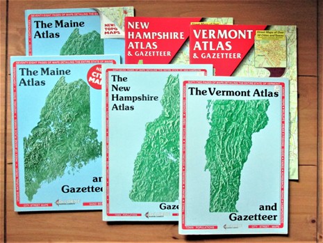
Above: The Maine Atlas and Gazetteer was the first of DeLorme's State Atlas and Gazetteer's. Initially, the New Hampshire and Vermont editions were published with the same light-blue covers as the Maine edition. As more states appeared in the series, various colours were used on the covers, such as yellow for Pennsylvania, Green for Ohio and Black for Washington State. However, eventually all atlases in the series were given the same style red covers more familiar today. Maine, however, being the home of DeLorme and where it all began, retained its traditional light blue cover and its title to include the word "The" at the start. Also seen here is a change in cartography - in the earlier days, Maine, New Hampshire and Vermont had a plainer (but very detailed) style using less colours on the page, whilst these were eventually replaced with a more modern style of cartography akin to that seen with the publication of other State Atlas and Gazetteers.
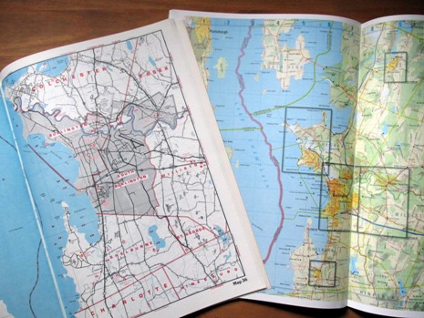
Although from the UK, the author of this webpage (already having a passion for maps) first stumbled upon what was to become a little obsession with DeLorme atlases during a vacation in 1990. Whilst travelling through New York State and purchasing a copy of DeLorme’s New York State Atlas and Gazetteer at a roadside stop, and using it ‘in the field’, it soon became apparent how much detail could be included in a single-volume atlas that covered an area a little more than the whole of England.
 |
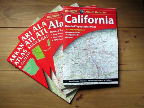 |
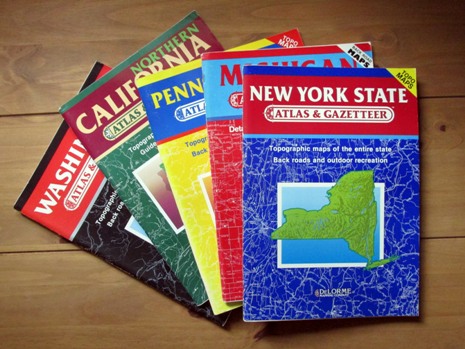
Above: As mentioned in the last photo caption, earlier editions of some of the DeLorme State Atlas and Gazetteer's were given different coloured covers (shown on left). This was at a time when the series was not complete. Later on (from c. 1990), all editions were given a more familiar red cover (shown on right), with the exception of Maine. As the series expanded, and also with newer editions of existing Atlas and Gazetteer's, further additions were incorporated, such as GPS coordinate data, although a more in-depth description of all new features goes beyond the scope of this Webpage.
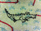
Spending many hours pouring over a few more Atlas and Gazetteer’s in the series, it wasn’t too long before the author here discovered in the Pennsylvania atlas a strange looking symbol located by the town of Punxsutawney. Being in the few years just before the World Wide Web went online to the world, it took a little time to figure out that this symbol was a Groundhog, something for which Punxsutawney is well-known in America and was much lesser known about in the UK (until, perhaps, the release of the film Groundhog Day in 1993). It wasn’t long after, a Flamingo was discovered in the Florida Atlas and Gazetteer, adjacent to the locality of the same name. One or two discoveries in other State Atlas and Gazetteer’s (such as a Bigfoot) led to the realisation that probably every volume in DeLorme’s mapping series contained one of these ‘secret symbols’, or ‘hidden symbols’, or more widely known in products of various types as ‘Easter Eggs’*. The author’s notion of each atlas containing one of these ‘Easter Eggs’ (with some sort of connection to the area covered) became verified some years later, through an internet search, although no single resource was ever found that listed all of these and explained where to find them (this is not to say such a resource has never been created). It was concluded that these hidden symbols were probably more for a bit of fun, a publisher's inside-joke, rather than for the serious business of mapmakers including deliberate errors as a tool for catching out unauthorised reproduction of their map data. Thus, plenty of time has been spent here, tracking down these little hidden symbols (still not a 100% complete project).
It is not my intention to provide a ‘spoiler’ here and give the exact location of these symbols. The whole point of looking for them has been both great fun and at times quite frankly tedious, but always educational. The table below presents those located by the author to date. Some of them may lead the reader to locate them in an obvious place, whilst others simply do not reveal any clues as to their whereabouts within a volume. And so, my findings are as follows, after spending many hours of searching… many hours:
|
Hidden Symbol |
Atlas and Gazetteer | Year Pub. | Description |
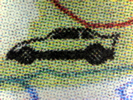 |
Alabama | 2010 | NASCAR Racecar |
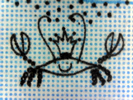 |
Alaska | 1992 | King Crab |
 |
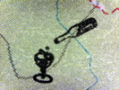
Arizona | 1993 | Toad with a Mexican Hat (A Mexican Spadefoot Toad?) |
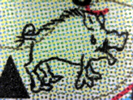 |
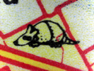
Arkansas | 1997 | Hog |
 |
N. California | 1988 | Wine Bottle and Glass |
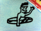 |
S&C. California | 1990 | Surfer |
 |
California (Whole State) | 2018 | N/A |
|
|
Colorado | 1991 | N/A |
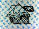 |
Connecticut, Rhode Island | 1999 | Pirate Ship |
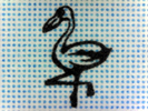 |
Florida | 1989 | Flamingo |
 |
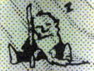
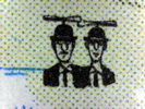
Georgia | 1998 | Oliver Hardy |
 |
Hawaii | 1999 | Book 'em Danno (from TV Series Hawaii Five-O) |
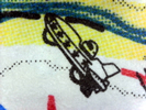 |
Idaho | 1992 | Evel Knievel in his 'Skycycle X-2' |
 |
Illinois | 1991 | Abraham Lincoln (Silhouette) |
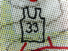 |
Indiana | 1998 | Basketball Jersey #33 - Larry Bird's number |
|
|
Iowa | 1998 | N/A |
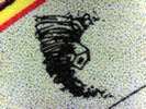 |
Kansas | 1997 | Tornado Carrying a House Away |
 |
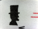
Kentucky | 1997 | Coonskin Cap (Associated with a Famous Frontiersman) |
 |
Louisiana | 1998 | Alligator |
|
|
Maine | 1994 | N/A |
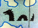 |
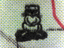
Maryland, Delaware | 1993 | Chessie the Sea Monster |
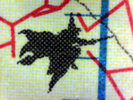 |
Massachusetts | 1998 | Witch |
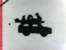 |
Michigan | 1989 | Car (With Undetermined Item(s) on Roof) |
 |
Minnesota | 1990 | Viking Helmet |
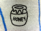 |
Mississippi | 1998 | Jar of Honey |
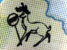 |
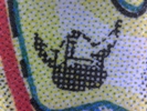
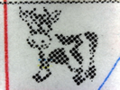
Missouri | 1998 | Deer Encountering a Stop Sign |
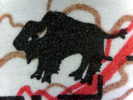 |
Montana | 1994 | A Bison |
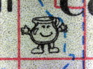 |
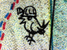
Nebraska | 1996 | Kool-Aid Man |
 |
Nevada | 1996 | Elvis |
 |
New Hampshire | 1996 | Hamster |
 |
New Jersey | 1999 | A Devil Figure |
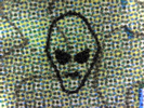 |
New Mexico | 1998 | Alien Face |
 |
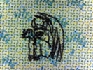
New York State | 1988 | Rip Van Winkle |
 |
Upstate New York, City Street Maps | 1990 | Daredevil in a Barrel |
 |
North Carolina | 1993 | The Wright Brothers |
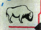 |
North Dakota | 1999 | Bison |
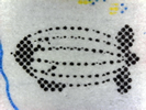 |
Ohio | 1987 | A Blimp |
 |
Oklahoma | 1998 | An Eye |
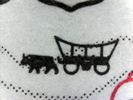 |
Oregon | 1991 | Ox-Driven Covered Wagon |
 |
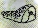
Pennsylvania | 1990 | Groundhog |
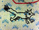 |
South Carolina | 1998 | A Fox (reference to Gen. Francis Marion) |
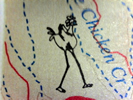 |
South Dakota | 1997 | A (Tall) Prairie Chicken |
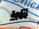 |
Tennessee | 1989 | Small Train |
 |
Texas | 1995 | Armadillo |
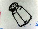 |
Utah | 1993 | A Salt Shaker |
 |
Vermont | 1996 | Champ (or Champy) the Lake Monster |
 |
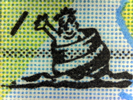
Virginia | 1989 | A Ham |
 |
Washington | 1988 | Bigfoot (Literally Taken) |
 |
West Virginia | 1997 | Coal Mining Canary |
 |
Wisconsin | 1988 | Dairy Cow |
 |
Wyoming | 1992 | UFO over a Famous Butte |
Note to learned readers only: As you
may have seen, four hidden symbols in the table above are still yet to
be found (as of September, 2021); if anybody knows the whereabouts of these, in the following DeLorme
Atlas and Gazetteer’s, then I would
really appreciate some help in finding them myself:
Colorado (1991 ed.)
Iowa (1998 ed.)
Maine (1994 ed.)
California (2018 ed. - one volume covering entire State)
Contact
Here. It is possible the year
given above is not relevant. All other atlas' hidden
symbols successfully located for the editions I have had access to. I
will happily credit on this webpage anybody else’s findings, as
appropriate. Oh what the heck... if I am in a good mood, I may even send
out some small prizes to the first person or persons who provide me with
the information I am after in order to locate these "missing hidden
symbols".
Thank you!
* ‘Easter Eggs’ are things deliberately included in something (e.g., book, software, film, music) by the creator, with a view to making them undocumented, hidden, and non-obvious to the end-user. A more thorough description of this term is given in the eeggs.com website Here (external link).
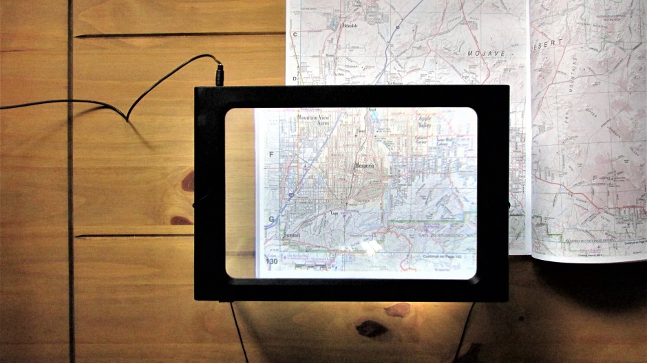
Above: An on-and-off project lasting multiple decades eventually led the author of this webpage to invest in a reading magnifier, complete with lights, to help scan map pages with more clarity!
References and Further Information
1. DeLorme Atlas and Gazetteer complete series (various editions)
2. 'DeLorme' - Wikipedia article
Here (external link)
Note: DeLorme and Garmin are Registered Trademarks and neither of these businesses sponsor, authorize, or endorse this personal webpage. I also bring the reader to the attention of this Website's Disclaimer, which may be found Here.
Back to Top