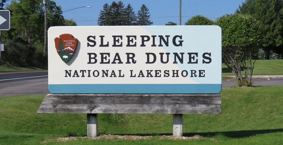
Sleeping Bear Dunes National Lakeshore
The Sleeping Bear Dunes National Lakeshore is located on the northern coast of the Lower Peninsula of Michigan, USA. This untouched 71,000-acre wilderness is a highlight of the area and is constantly being re-sculptured. This natural landscape comprises precipitous bluffs that tower up to 450-feet above its miles of sandy beaches, towering dunes, beech-maple forests, clear inland lakes, and unique flora and fauna.
Sleeping Bear Dunes National Lakeshore lies on Lake Michigan, the largest lake completely within the United States and the fourth largest fresh-water lake in the world. Lake Michigan has had a profound influence on the region, including the formation of the sand dunes. The area was named by the Ojibwa (Chippewa), who saw the mist-shrouded North and South islands as the graves of two drowned bear cubs and a gigantic mainland dune as their grieving mother.
In order to know where to go and how to see the park in a safe and responsible manner, a useful first stop is the visitors centre, before heading for the stunning overlooks of the dunes and the park’s main lake, Glen Lake, on the hilly 7.4-mile loop of the Pierce Stocking Scenic Drive. Another attraction is the Dune Climb, a 200-foot high sand dune two miles further north. All of these are featured on this website. Further north are further attractions, some of them historical, and these are briefly described further down this webpage. For the reader, there is a fully zoomable map centred on the park embedded at the end of this webpage. The photographs shown here are taken from the visit to the National Lakeshore, which took place in September, 2018.
The Ojibwa (or Ojibwe) were a tribe belonging to the Anishinaabe group of culturally related indigenous peoples. The name Sleeping Bear Dunes comes from their traditional folklore. Long ago, the Ojibwa story goes that in the land now known as Wisconsin, a mother bear and her two cubs tried to swim across Lake Michigan. This was to escape terrible hunger in Wisconsin, where many people and animals died. Close to the shore, the cubs found it too tiring and whilst lagging behind. Mother bear made it to the shore and climbed to the top of the bluff to watch and wait for her cubs. The cubs never reached her and drowned. A solitary dune covered with dark trees and shrubs arose where the mother ear waited. Offshore, the Manitou Islands (which can be seen from the shoreline) mark the spots where the two cubs drowned. Today, the land of the Sleeping Bear is preserved as Sleeping Bear Dunes National Lakeshore.
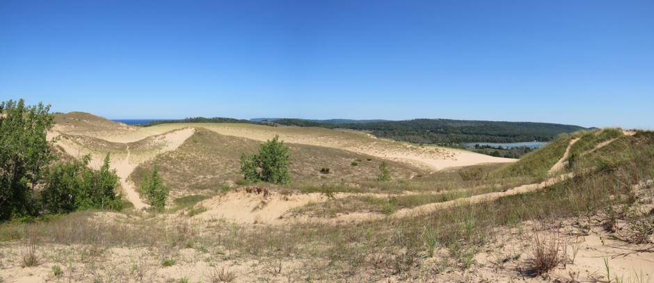
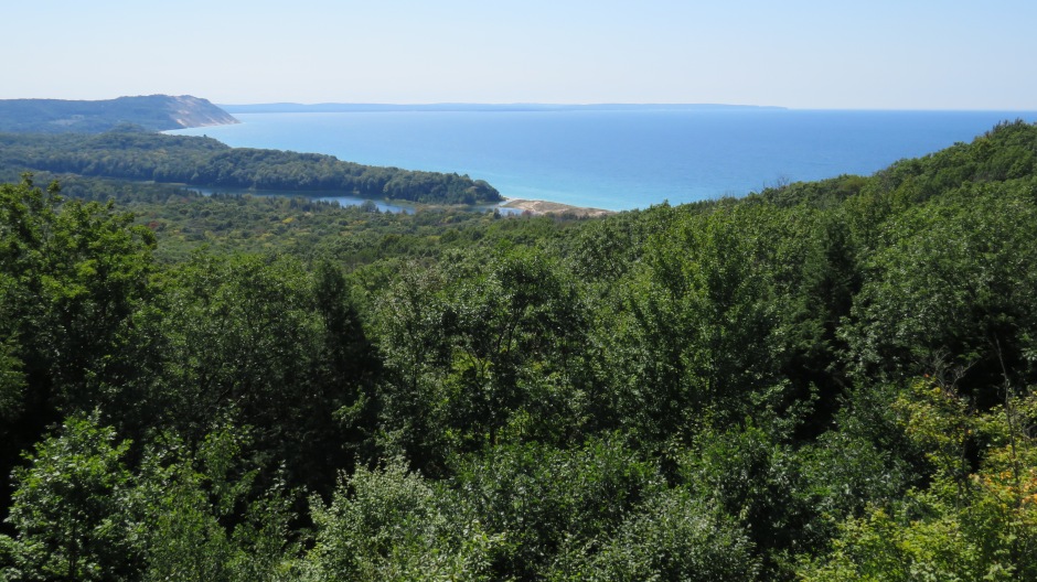
Above: Panoramic stitch, showing a view of Sleeping Bear Dunes National Lakeshore from the Dune Climb. The body of water just visible on the horizon towards the left in the photograph is Lake Michigan, whilst on the centre-right is Glen Lake.
Following the retreat of the last glaciers from the Ice age, prehistoric people were active in the area. They lived in seasonal camps, carrying out activities such as gathering, fishing, hunting and trapping. The Anishinaabe people were living here when the first Europeans arrived in the mid-1600’s. In the early to mid-1800’s, Europeans settled on the Manitou islands and later moved to the mainland.
Visitors Centre
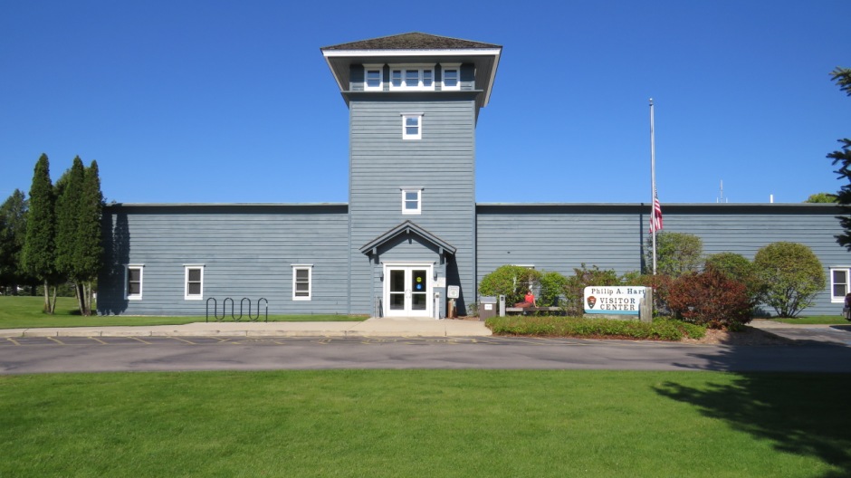
The first stop on the visit to the Sleeping Bear Dunes National Lakeshore featured on this webpage was to the Philip A. Hart Visitor Center. It is located in the village of Empire, 24 miles west of Traverse City on Hwy-72. Inside, there are informative exhibits and a video, as well as staff on-hand to provide answers to any questions regarding the park. It is here, a pass was purchased, which enabled access to the park and was a single price for a car. Some photographs from the visitors centre are shown in the thumbnail gallery below (click on an image to enlarge):
Pierce Stocking Scenic Drive
After the visitors centre, a beeline was made for the stunning overlooks of the dunes and the lake along the 7.4-mile loop of the Pierce Stocking Scenic Drive, off Hwy-109 (Open May to mid November daily 9am to 8pm or 30 min after sunset). Pierce Stocking (1908-1976) was a local lumberman who wanted to preserve the area’s natural beauty. In the early 1960’s, he began envisioning “a haven of rest” called Sleeping Bear Dunes Park. Opening to the public in 1967, for $2.75 per vehicle, visitors could drive what was then a 14-mile scenic roadway, stopping off at picnic areas and taking in views of the sand dunes, Lake Michigan and Glen Lake. When Sleeping Bear Dunes National Lakeshore purchased Stocking’s park in 1976, they renamed it Philip Hart Nature Trail (after a US Senator who fought to establish the Lakeshore six years earlier). One idea at the time was to remove the scenic drive to help protect the dunes. However, they were to realise what Stocking has, namely that if you want people to love this earth enough to conserve it, they also have to be able to enjoy it. And so, the scenic drive remained (although shorter today) and the Lakeshore renamed it in honour of stocking and his resolve to preserve this place for future generations. As seen earlier on this webpage, the visitors centre today bears the name Philip A. Hart, and so the Senator’s name is still remembered.
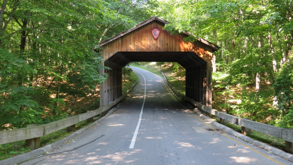
The first stop along the 7.4-mile loop of the Pierce Stocking Scenic Drive is just after passing the Covered Bridge (above). The Lakeshore rebuilt Stocking’s covered bridge in 1986 in order to accommodate taller vehicles and also to repair damage caused by munching porcupines.
The next stop along the one-way scenic drive was at the Glen Lake Overlook. As lumbering declined in the 1900’s, tourism began to take off, with travel writers calling Glen Lake the “Switzerland of America”. An original plan by a gentleman named D.H. Day would have seen the area turned into an ambitious resort. However, he passed away in 1928 and the stock market crashed a year later. Consequently the project failed and as a result, in the 1940’s state residents and officials were able to imagine a new use for the land – not a playground for rich people, but a park for all to enjoy.
 |
 |
|
 |
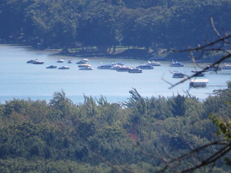 |
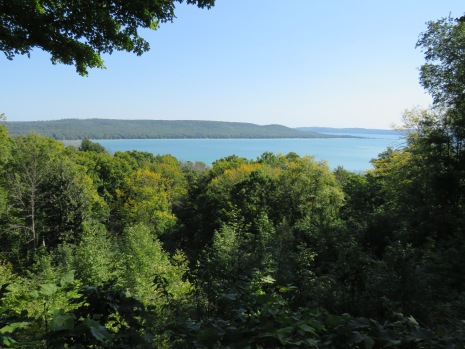
The photographs above show views from the Glen Lake Overlook. The landscape was brought about by ice, up to a mile thick, when glaciers advanced from the north over two million years ago. Creeping along like giant bulldozers, they moved rock and soil, gouging, carving, deepening and widening existing drainage channels and rivers. Around 14,000 years ago, temperatures warmed and the glaciers started to melt, leaving piles of sand and gravel (moraines) in their wake, as well as ridges, glacial kettles, and other glacial landforms. Eventually, the glaciers thawed, turning their deep tracks into large lakes of melt-water. One of these ancient lakes, Lake Nipissing, through time, became Lake Michigan, as its water level fell. Meanwhile, waves were eroding beaches and bluffs, whilst currents carried sediment along the shore to form sandbars. By approximately 2,000 years ago, these currents had deposited enough on either side of an island (now known as Alligator Hill) to landlocked Glen Lake. Over the years, grasses and trees took root. Today, this forested sandbar is the location of the town of Glen Arbor, just to the north of Glen Lake, and a beach of ancient sand. Typical lakes within forested areas are fed by runoff. Soil, leaves, and other dissolved organic matter make the water dark in appearance. However, Glen Lake is largely fed by clear groundwater, not runoff and so this allows sunlight to easily penetrate deep into the lake, where only shorter blue light is reflected. The result of this is that Glen Lake has more of a bluish appearance than many other forested lakes.
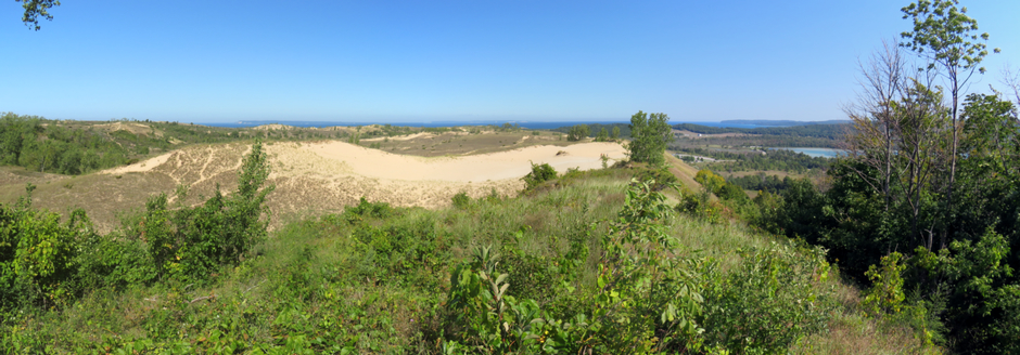
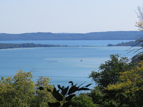
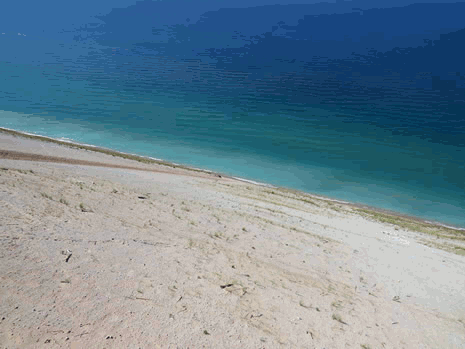
Just past Picnic Mountain, the next stop on the scenic drive made on this visit was at the Dune Overlook, the view from which may be seen in the panoramic stitch photograph above. Note that the body of water on the horizon in the central part of the photo is Lake Michigan, whilst that to the right is the aforementioned Glen Lake. Since the times when the glaciers here melted over 10,000 years ago, westerly winds, water and weather have continued to impact the land. Sometimes the change is gradual, but occasionally storms transform the landscape in a matter of hours. The dunes are the most prominent feature here and are most affected by winds blowing across Lake Michigan. They form part of a larger system of dunes stretching along western Michigan which is the largest freshwater dune system to be found anywhere in the world. The tallest dunes seen here are perched dunes; piles of sand blown onto the tops of glacial moraines, which are composed of rock and sand debris. Also found here are lower beach and falling or de-perched dunes. Some more photos take from the Dune Overlook stop are shown in the thumbnail gallery below (click on an image to enlarge):
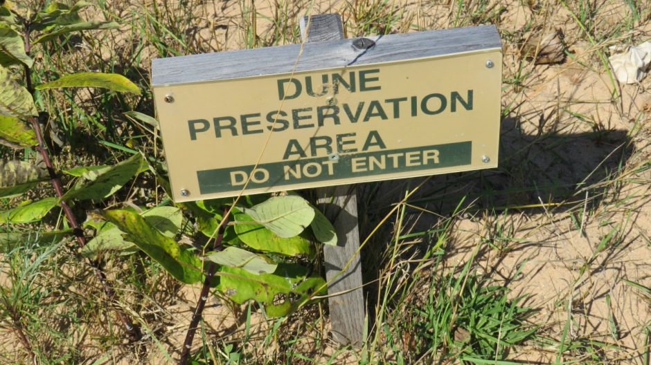
In essence, the dunes go through a cycle of change. 80% of the park is forested and at one time, most of that land was sand. Whilst the forest advances on the dunes, the dunes are infiltrating the forest. This cycle of transformation is known to ecologists as “succession”. It begins with sand and wind forming the dunes. Dunes cannot form if the sand keeps on moving. Where marram grass starts growing, it acts like a net, to trap grains of sand, holding them in place. Once the dune is stabilised with the grass, cottonwood trees start to grow. When sand buries their branches, they clone themselves, sprouting roots to grow new trees. Sand cherry and juniper shrubs help shelter other plants from the sun and sand and help to prime the soil with their fallen leaves. Following this, trees that thrive in sunlight, like birch and aspen start to appear, creating shade which, in turn, enabling pine and oak trees to move in. Finally a forest of tall, shade-tolerant trees appears, comprising such species as basswood, beech, hemlock and maple, replacing the sun-lovers. The dense cover of the forest provides a habitat for many native animal species, including deer, porcupines and woodpeckers. Once established, the forest remains stable until wind, flooding, fire or disease fells the trees. Such disturbances allow sand to blow in. Unlike cottonwoods, most trees are not able to survive the abrasion and dehydration when submerged in sand and so the forest dies. The sand eventually migrates, exposing the sun-bleached “bones” of former trees. These dead, hollow logs help support animal species, such as salamanders, snakes and insects, as well as fungi. They also serve as nurseries for future trees. In terms of habitats within the park, as well as the dune and forest habitats within the park, the lakes and streams support a variety of freshwater aquatic life and the beaches attract many shorebirds, including piping plovers which nest here.
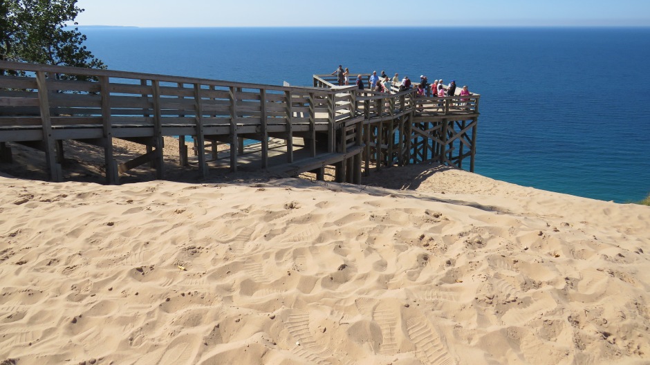
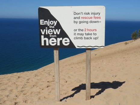
Our next stop was at the Lake Michigan Overlook. In 1983, The Lakeshore built a viewing platform here and in 1987, they added a new approach ramp on top of the older one (see photo above). The overlook is an impressive 450 feet (137m) above Lake Michigan and provides a magnificent view of the shoreline. During days of good visibility, to the south it is possible see Empire Bluffs, four miles away and Platte Bay, nine miles away; both of these are within the 106 square-mile area of Sleeping Bear Dunes National Lakeshore. Still further south is Point Betsie, the farthest point of land, 15 miles away as the crow flies. To the west, it is 54 miles across the Lake Michigan to Wisconsin. As mentioned, the overlook is 450 feet above Lake Michigan and looking down, it was near-impossible to get a sense of scale as to how far down to the edge of the lake it is. It was only until someone walking by the lake was spotted, did the height of the overlook become apparent. It felt that no single photograph could put things into perspective and so, by way of an animated GIF image, the view from the overlook (alongside a warning sign) is shown below:
 |
 |
The Sleeping Bear itself is a large dune about a mile away from here, perched along the edge of the bluff. She hardly looks like a bear now, but in 1721, French historian Pierre Charlevoix canoed past the dunes and described “a kind of bush” shaped like “an animal lying down”. From the early 20th century, a series of natural events and human intrusions inflicted irreversible damage on the Bear and the erosion continues; in 1935, a trail was cut up the Bear’s southwest face in order to carry out work placing a marker for the Coast and Geodetic Survey of the Great Lakes. The trail was in line with strong winds off the lake and this marked the beginning of the end of the Bear’s shape. Wind felled a 200-year old pine and by 1941, all trees on the southwest slope had either rolled down into the lake, or been used for campfires. Soon, dune rides were parking at the base of the Bear. Until today, decades of wind from the southwest have blown sand up and over the Bear, burying the north-eastern trees and the whole perched dune is now creeping in that direction. The thumbnail gallery below shows some more photographs taken from the Lake Michigan Overlook (click on an image to enlarge):
To the north of Sleeping Bear Dunes National Lakeshore lies a treacherous part of Lake Michigan, known as the Manitou Passage. This is a 36-mile long waterway between the mainland and the two Manitou islands. The passage is a main shipping lane through Lake Michigan and provides one of the few sheltered bays between the straits of Mackinac and Chicago, but hides hazardous shoals and sandbars. Before the age of modern navigation, stranded and wrecked ships were commonplace, leading to the construction of the South Manitou Lighthouse in 1839, the North Manitou Lighthouse in 1896 and the North Manitou Shoal Light in 1935. To date, archaeologists have discovered at least 60 shipwrecks and a large number of “ghost ships” remain lost below the lake’s surface.
Above: View from the North Bar Lake Overlook
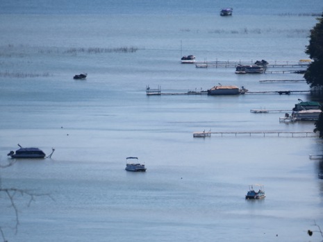
Our final stop on the Pierce Stocking Scenic Drive was at the North Bar Lake Overlook. The overlook here is at the southern end of the scenic drive and offers views in a southerly direction towards North Bar Lake and beyond to Empire Bluff. The stop here has a picnic area, perhaps ideal for those whom have spent a morning or afternoon taking the sights in along this magnificent 7.4-mile route. The view from the North Bar Lake Overlook is shown in the photo above and just visible in the centre and left half of the picture is North Bar Lake. The name describes how this small lake was formed; it is ‘ponded’ from Lake Michigan by a sand bar. At times, the sand bar builds up and separates it from Lake Michigan. At other times, a small connecting channel exists between the two lakes. North Bar Lake is located on what was once part of a bay on Lake Michigan. This ancient bay was flanked by headlands on both sides, namely Empire Bluffs to the south and Sleeping Bear Bluffs to the north. Shorelines have a natural tendency to become straighter through time. Wave action is more active on the headlands and erosion is greater, whilst shoreline currents carry sediment to the quiet bays and fill them in. Deeper parts of the bay are often left as lakes whereby sand fills in the shallower parts. As well as North Bar Lake, this same process formed many other lakes in northern Michigan, such as the aforementioned Glen Lake, as well as other lakes, including Crystal, Elk and Torch Lakes. North Bar Lake, itself, is a popular swimming area during the summer and is warmer than Lake Michigan. However, being so close to it’s considerably larger neighbour, this spot also gives the option of cooling off in the Great Lake’s waves, or taking long walks along its beach. From here, it is possible to walk to the base of the bluffs, just to the north - perhaps a more agreeable route than having to return to one’s vehicle via the 450 foot ascent up steep sand to the Lake Michigan Overlook!
Dune Climb
To the north of the Pierce Stocking Scenic Drive start/finish point, just off Hwy-109, to the west of the road, is the Dune Climb. Here, there is a large car park and picnic area at the base of a large sand dune, which offers plenty of pure, wind-blown sand, for climbing up and is suitable for any able-bodies person, whether it be a short or longer walk or simply a place to picnic and for children to play. The reward for climbing up the dune is a view behind of Glen Lake.
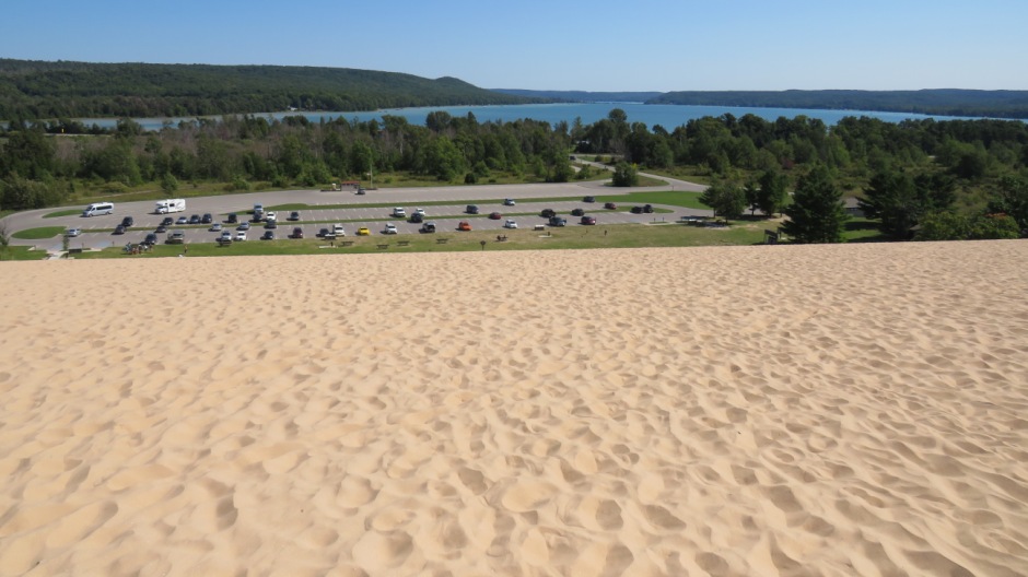
Above: View from the Dune Climb, looking back towards the car park and beyond, towards Glen Lake
The advantage of being at the base of the dune (as opposed to the Lake Michigan Overlook) is that whilst the climb can be strenuous, the walk back down to the picnic area is very easy going. The Dune Center, located at the base of the Dune Climb, offers modern restrooms and a bookstore. For those fit enough and with the time available, a hike can be taken, from the top of the large dune here, through the dunes all the way to Lake Michigan. This can normally take three to four hours and involves walking up and down dunes on loose sand (sensible precautions should be taken, such as taking plenty of water, a map and compass, appropriate footwear. sticking to the trails and keeping children in sight all of the time as the dunes can be disorientating). For those not climbing the dune, there is also the Sleeping Bear Heritage Trail, which leaves from the base of the dune at the northern end of the Dune Climb. Some more photographs taken from the Dune Climb can be seen in the thumbnail gallery below (click on an image to enlarge):
Other Places of Interest and Activities in the Sleeping Bear Dunes National Lakeshore
Other sites in the park (and further north and then east of the Dune Climb), include Sleeping Bear Point US Life-Saving Service Station Maritime Museum, Glen Haven Historic Village (Glen Haven played a role in three of Northern Michigan’s economic eras - lumbering, agriculture, and tourism.), Glen Arbor (which acts as the primary base for park activities and accommodation) and Port Oneida Rural Historic District (Settled mainly by German and Prussian immigrants, Port Oneida was a lumbering, farming and port community. Like Glen Haven, there are several attractions here which allow the visitor to ‘step back in time’). As well as sightseeing and picnicking, other popular activities in the park include hiking (there are over 100 miles of trails of varying difficulty), trips to the Manitou Islands (There is no commercial service, although Manitou Island Transit offer a ferry service from May to September and a camping permit is required o stay on the islands), Camping (there are several campsites within the park), Hunting and Fishing, Stargazing and various winter recreational activities. Whilst Glen Arbor makes for an ideal base for which to spend time at Sleeping Bear Dunes National Lakeshore, it is an easy day-trip from Traverse City. For further information, regulations and safety information, it is recommended to contact the visitor centre, ask a ranger, call or visit the National Park Service website (link Here).
Above: Zoomable map centred on the Sleeping Bear Dunes National Lakeshore (courtesy of openstreetmap.org)
References and Further Information
1. In Situ Information Boards and Literature
2. Edwards, N. (2017).
The rough guide to USA. London: Rough Guides.
Back to Top