Sometimes referred to as The Twin Sault Area, Sault Sainte Marie (or Sault Ste. Marie) is the name given to two cities separated by the St Mary’s River. One is located in south-central Ontario in Canada, and the other, bearing the same name is located in northern Michigan, USA. The former has a population of approximately 73,000, whilst the latter approximately 14,000. The two cities are joined by the International Bridge, which has a total length of 2.8 miles (4.5km). The two communities were originally one city, until a new treaty after the War of 1812 established the border between Canada and the United States which was to run along the river.
 |
 |
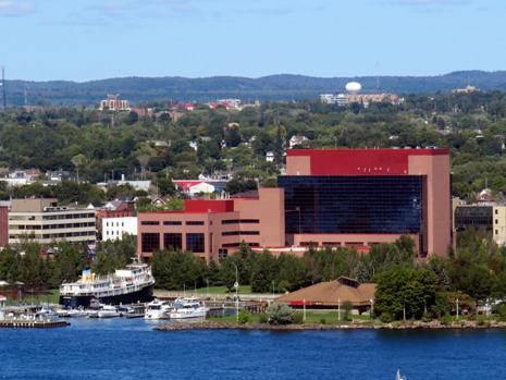
Above: Views of Sault Ste. Marie in Ontario, Canada (left) and Sault Ste. Marie in Michigan, USA (right)
The two cities are well-known for the Sault Sainte Marie Canals (Soo Canals). These artificial waterways run along the border between Lakes Huron and Superior and form a major link in the Great Lakes waterway. There are two canals, which bypass the rapids of the St Mary’s River. The Canadian canal, 1.4 miles (2.2km) long, was constructed between 1889 and 1895. The US canal, 1.6 miles (2.6km) long, was built between 1881 and 1919. Today, the total shipping via the American Soo Locks make it the world's busiest canal in terms of tonnage that passes through it, while smaller recreational and tour boats use the Canadian Sault Ste. Marie Canal. This webpage primarily focuses on a visit to Sault Ste. Marie in Ontario, although also features the city of the same name across the river in Michigan.
 |
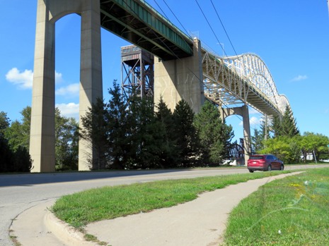 |
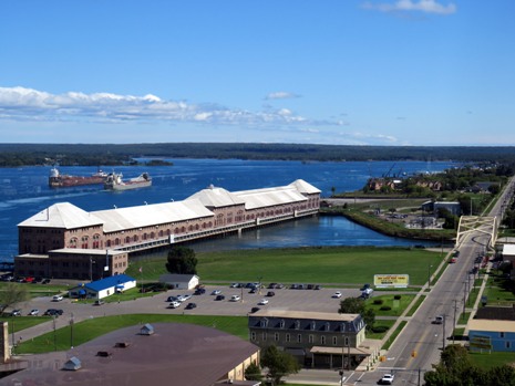
Above: A view of the St Mary’s River (left) and of the International Bridge, which connects the two Sault Sainte Marie’s (right)
Native American settlements existed here for more than 500 years. In the late 17th century, French Jesuit missionaries established a mission at the First Nations village. A fur trading post was subsequently established followed by more settlement traders, trappers and Native Americans were attracted to the community, at a time when (until after the War of 1812) both sides of the river were part of Canada. Once the border along the river was created, the United States did not allow British traders to operate on the American side and the two cities separated by the river began to develop as two communities both with the same name.
Above: Fully zoomable map centred on The Twin Sault Area (courtesy of openstreetmap.org)
Sault Ste. Marie, Ontario
The Canadian Sault Ste. Marie is the seat of the Algoma District and the third largest city in Northern Ontario, after Sudbury and Thunder Bay. French colonists who came to the area referred to the rapids on the St. Mary's River as “Les Saults de Ste. Marie” ("Saint Mary's Rapids" or "Saint Mary's Falls") and the early settlement’s name was derived from that. The word “Sault” is pronounced /su:/ in English. In the early days, the 6m (20 foot) descent of the rapids and cascades from Lake Superior to the level of the lower lakes meant there was a need for overland portage of boats and cargo from one lake to the other, hence the need for a system of locks. The Canadian canal itself is lined with attractive historic red sandstone buildings. Highlights in the city include the Ermatinger Clergue National Historic Site, the Art Gallery of Algoma (showcasing works by local, national and international artists), the Sault Ste. Marie Museum, Spruce Haven Zoo, the Museum Ship Norgoma and the Bushplane Heritage Centre, the latter being dealt with in more detail lower down the webpage. The city has many activities on offer including the OLG Casino Sault Ste. Marie, a mile-long waterfront boardwalk (excellent for viewing the large ships passing through the world’s busiest lock system), the Sault Ste. Marie Canal National Historic Site of Canada (at the most westerly point of land under the International Bridge), the Roberta Bondar Park and a range of annual festivals, concerts, as well as sporting events and entertainment at the Essar Centre, located in the downtown area. Furthermore, the city makes for an excellent base to explore Northern Ontario’s scenic wilderness; a train runs north from here during the summer (The Agawa Canyon Tour Train). Some general photographs of Sault Ste. Marie, Ontario, may be viewed in the thumbnail gallery below (click on an image to enlarge):
Heritage properties shown in the gallery above include the 1888 Algonquin Hotel (Photo 2), the 1876 Precious Blood Cathedral (Photo 3), the 1902 Old Post Office Building (Photo 4), the 1922 Sault Ste. Marie & District Courthouse (Photo 6) and the Sault Ste. Marie Memorial Tower (Photo 10). As mentioned previously, next on this webpage is some information (and photographs) on the Bushplane Heritage Centre. This is followed by some information from a visit to the Attikamek & Whitefish Island Trails, which are also to be found on the Canadian side of the river.
The Canadian Bushplane Heritage Centre
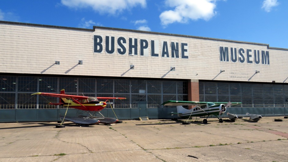
The Canadian Bushplane Heritage Centre (CBHC) in Sault Ste. Marie, Ontario, is the only museum dedicated to preserving the history of bush planes and forest fire management in North America. The CBHC is a non-profit charitable organisation dedicated to the collection, preservation, restoration and display of planes and equipment here. The museum comprises some 64,000 square feet of interactive aviation and forest fire exhibits in a historic hangar where water bombing from planes was first developed. The hangar was home to the Ontario Provincial Air Service (OPAS), which was established in 1924 to protect Ontario’s forest resources. The navigable photo gallery below shows all of the planes which were on display inside the centre at the time of the visit (in September, 2018), with a brief description underneath each image:
In addition to the planes on display at the CBHC, other exhibits include Tribute to Roberta Bondar (the first Canadian woman in space and a Sault Ste. Marie native), Fire Camp (an exhibit portraying the temporary camps used by fire crews in the 1940’s for extinguishing forest fires on the ground), Engine Test Cell (the only functional engine test cell in a museum in the world), Children’s flight Centre (containing many educational, interactive and hands-on aviation related exhibits), Forest Fire Exhibit (includes a real fire tower to climb, radio and Morse code communication devices and a lightning strike indicator), Object Theatre (featuring “Wings Over the North – A Bush Plane Adventure” with film and objects/artefacts, bringing the story of a fire fighter and his dog in his plane to life) and the Wildfires! 3D Adventure (telling the story of how wildfires are fought in Ontario). See www.bushplane.com for further information. Some photographs taken from outside the CBHC and of the (non-plane) exhibits inside are shown in the thumbnail gallery below (click on an image to enlarge):
Attikamek & Whitefish Island Trails
Located within the Sault Ste. Marie Canal National Historic Site are a series of trails, ideal for those wishing to see the canal system up-close, those seeking views over the St. Mary’s River, walkers and nature lovers alike.
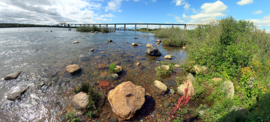
Above: Panoramic stitch of photographs showing the St Mary’s River and the International Bridge as seen from Whitefish Island
At the time of its completion in 1895, the Sault Ste. Marie Canal was the world’s longest and first electrically operated lock which completed an all-Canadian waterway spanning from the Atlantic Ocean to the western-most tip of Lake Superior. This historic canal has since been equipped with a modern lock and continues to be used by recreational boaters from May to October. It is possible to view the original equipment still in use today. There is a seasonal visitor’s centre here, where further information is available, including a map of the beautiful nature trails. Historic landmarks to look out for within the site include the six small Motorhouses (1895), the two-storey Stores Building (1896), the Powerhouse (1894), the Canalmen’s Shelter (1906), the 1896 Administration Building, the Superintendent’s Residence (1897) and the Emergency Swing Dam (1895). Some photos from a walk along the trails are shown in the thumbnail gallery below (click on an image to enlarge):
Sault Ste. Marie, Michigan
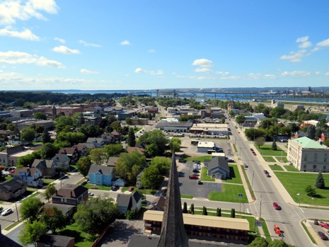
Sault Ste. Marie, Michigan, was established in 1668 on the eastern shores of Lake Superior and along St. Mary’s River as a permanent settlement. It is the oldest city in the state and the third oldest city in the United States. In the mid to late 1700’s, the French and British often fought over the area; conflicts were generally over British trade with the Native Americans and both countries flew their respective flags over the city on more than one occasion. Today, the Soo Locks here represent an incredible feat of engineering and continue to be a source of pride for the local citizens. The city offers a great deal for the visitor, whether it is for people on vacation, to history enthusiasts coming here to trace the early history of the Great Lakes region. Attractions not only include the Soo Locks and Boat Tours, but also the Museum Ship Valley Camp, The River of History Museum and the Tower of History, the latter being featured (with views from atop) in the thumbnail gallery below (click on an image to enlarge):
References and Further Information
1. In Situ Literature and Information Boards
2. Wikipedia
Back to Top