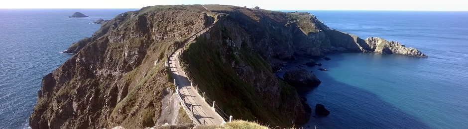
Above: La Coupée connects Greater and Little Sark
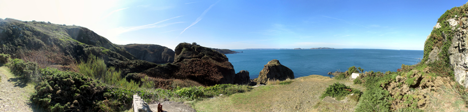
Sark is the fourth largest of the Channel Islands and is located in the English Channel just off the French Normandy coast, around 80 miles (130km) south of England. Sark has an area of 2.10 square miles (5.44km²) and consists of two main parts, Greater Sark to the north, and Little Sark to the south. Greater and Little Sark are connected by a narrow precipitous strip of land called La Coupée. The coastline totals some 22 miles, characterised by spectacular scenery, with numerous sea cliffs, pebbly coves, sandy beaches, headlands and coastal walks.
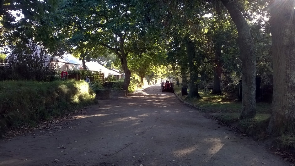
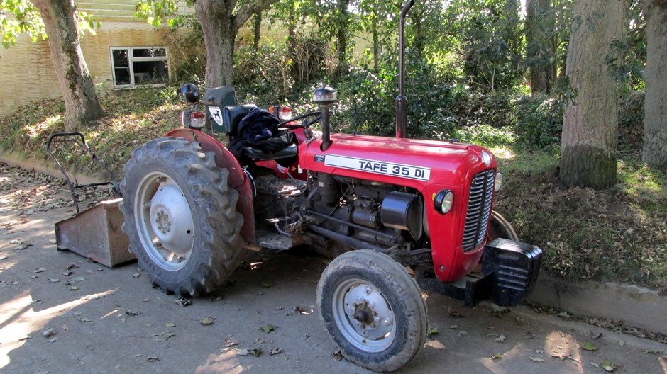
The community on Sark is very much alive, with a resident population of around 550 inhabitants living in an idyllic setting. Amenities include shops and cafes, a post office, two banks, a school, a Doctor and a Constable as well as a couple of hotels and a good selection of guesthouses. Despite all this, the island is known for it's hard-line approach to being transformed into modern times. There are no cars or motorbikes here. The only motorised vehicles to be seen here are tractors, supported by horse-drawn carriages. Indeed, the fire engine and ambulance are pulled along by a tractor. A common way to get about, both locals and tourists alike, is by bicycle (cycle hire is available) although due to the relatively small size of the island, it is also possible to explore on foot (in some areas, this is the only option). The island is certainly cycle and pedestrian-friendly with no cars about.
Map Source: Openstreetmap.org
A visit to Sark is ideal for anybody wishing to step back in time and take in some natural coastal beauty, wildlife and general peace and tranquillity, whilst finding the friendly people and their way of life a refreshing change from the stresses of modern-day society. Income tax and VAT are unknown here and the visitor will be relieved to also know many (but not all) places have Wi-Fi!
A potted history of the island follows. The Channel Islands have belonged to the Crown since the time of William the Conqueror when they formed part of the Duchy of Normandy. In 1565, Queen Elizabeth I granted Letters Patent to Helier de Carteret, a Jerseyman who colonised Sark. Granting ownership in this way founded the basis of a feudal society on the island, a system of government that continued right through to the early 21st century. One exception to this, however was from 1940-1945, when the island was occupied by German forces along with the rest of the Channel Islands during World War II. Sark remained the last feudal state in Europe until December 2008, when it bowed to pressure from the European Court of Human Rights and held its first ever democratic elections. The island's 28-member Parliament, or Chief Pleas, meets at least four times per year, governing the island and passing new laws which can be vetoed by the Guernsey Royal Court if circumstances warrant. Historically, many of the laws on the island are what some may describe as archaic, for example those relating to divorce being illegal and inheritance. The Island has been ruled by a Seigneur, the Lord of the Manor, ever since de Carteret became the first. In 1990, Sark was home to a bizarre invasion in the form of an unemployed French nuclear physicist, André Gardes. His plan was to conquer the island himself single-handedly. Armed with a semi-automatic weapon, he decided to announce upon his arrival that he was going to take over the island at noon the next day. He put signs up around the island and flyers telling people. However, whilst waiting the for noon the next day, the Frenchman was found sitting on a bench by Sark’s volunteer police constable. Unfortunately for André, his gun and ammunition were not at the ready. The officer punched him in the face and arrested him, thus bringing the impending island takeover to an abrupt end.
Wild flowers, insects, birds and marine life are in abundance on and around Sark. Due to it's geographical location, Sark has a mild climate meaning a few species here are either rare or never to be typically spotted in the rest of the British Isles. On parts of the island, particularly on the western Gouliot Headland, sea caves exposed at low spring tides are carpeted with anemones, sponges and soft corals. The headland above supports a wealth of wildflowers; the Gouliot Headland itself was declared a Wetland of International Importance under the Ramsar Convention in 2007. For views of the coastline, boat trips are available. All year round, there are oystercatchers, fulmars and peregrine falcons whilst springtime brings puffins, razorbills and the largest guillemot colony in the Channel Islands. The rich variety of marine life means Sark is a popular destination for scuba diving activities.
Access to Sark is by boat as there is no airport. Aircraft are not allowed to fly over the island without permission of the Chief Pleas. In other words, only if there is a very special reason, such as a Royal visit. Even medical emergencies have to use boats to take patients to Guernsey, either by the St Peter Port lifeboat or the St John Ambulance boat. The Isle of Sark Shipping Company provides the passenger ferry (approx. 55min crossing) and cargo services from Guernsey. Although a landing tax is applicable to passengers arriving by ferry, this is included in the price of a ticket. There are several passenger sailings per day in the peak holiday season with ferries departing from the Inter Island Quay at St Peter Port Harbour on Guernsey. Tickets available online (link at bottom of this page) or from the White Rock office in Guernsey and the Maseline Harbour office in Sark. Manche Iles Express provides a passenger ferry services from France via Jersey. This service varies in number per week depending on the time of year. The journey time from France to Jersey is approx. 1hr, as is the journey time from Jersey to Sark. It is worth noting here that all crossings are subject to changes in the weather. As mentioned earlier, for visitors wishing to stay on the island, there are a couple of hotels and a good selection of guesthouses. In addition, there is also a fine selection of self-catering accommodation/gîtes and also two campsites.
Below is an extensive thumbnail gallery showing photos taken from a walk around the island (click on images to enlarge). A description of selected photos of some of the main sights then follows.
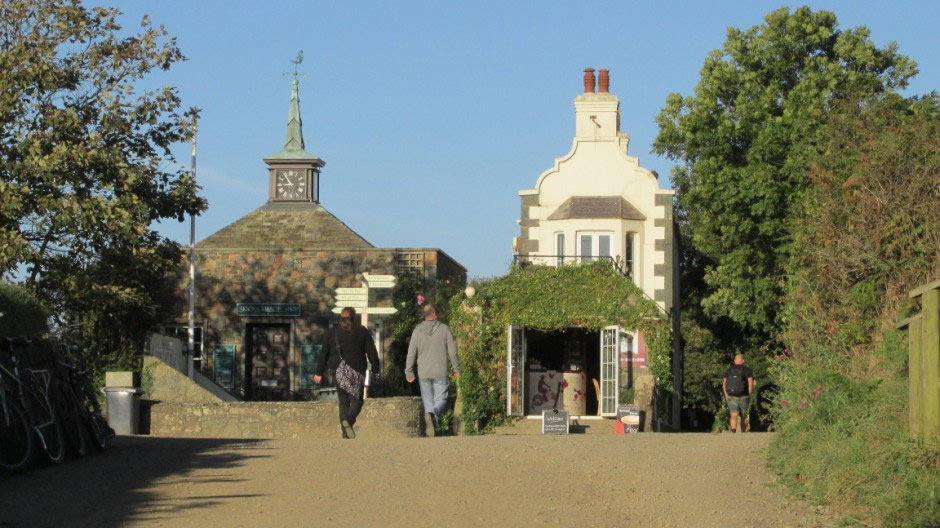
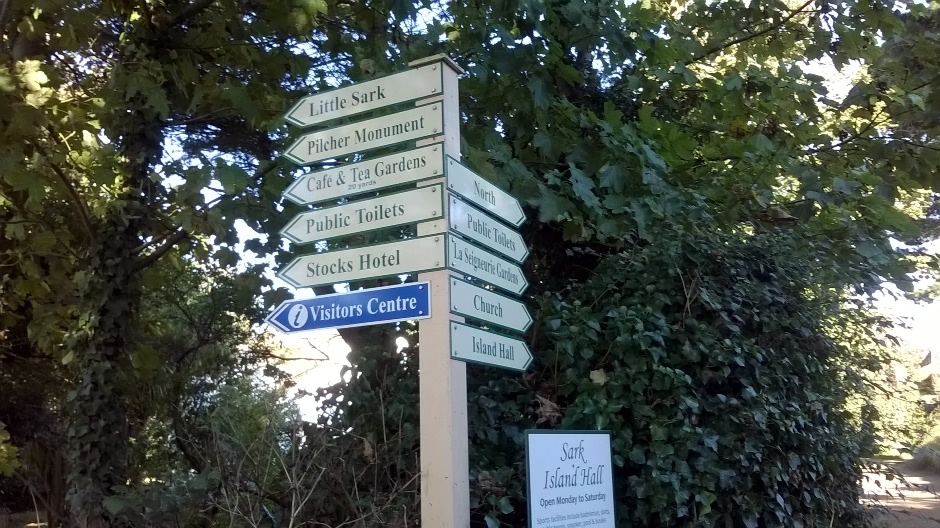
As a visitor, it is likely you will arrive via a passenger ferry at La Maseline Harbour [Photo 3, above]. There are two harbours at Sark, each connected via separate tunnels to a terminus at the bottom of Harbour Hill [Photo 7]. On disembarking, after walking through the tunnel, there a couple of options available. One is to travel up Harbour Hill in the tractor bus [Photos 8, 10, 11], otherwise known as "the toast rack" and the other option is to walk up a meandering path running alongside the Harbour Hill Road. The tractor bus heads up the steep Harbour Hill to the Bel Air Tavern, one of three public houses on the island, and then a short stroll takes you into the centre of the village. The decision on how to explore the island than can be taken - either by horse-drawn carriage, bicycle or on foot. For visitors staying on the island, you will find your luggage is transported from the boat straight to your accommodation. Carrying straight on from the main crossroads [Photos 12-16] leads you down the Avenue [Example photos 17-24]. The Avenue is the 'High Street' of the island. Along here are various shops and cafes, the Sark Post Office [Photo 23], which sells Guernsey stamps (as UK stamps are not valid) and cycle hire (there are three cycle hire providers on the island). Most daily requirements can be found along the Avenue and Newspapers come in daily by boat from Guernsey. The two banks on the island are HSBC at the bottom of The Avenue [seen later on in Photo 129] and NatWest at the Sark Post Office. The official currency here is Sterling, though this can be in Bank of England, Jersey or Guernsey form. At the western end of the Avenue stands the Official Sark Visitor Centre [Photo 24] in the old school building and beside this, the tiny prison [seen later, in Photo 80]. The visitor centre is staffed by local people ready to answer any questions you may have and stocks a wide range of information resources. Bookings can be made here for guided walks and boat trips. Next door is La Société Sercquaise room, which contains various exhibitions about Sark on display.
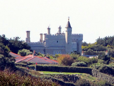
Heading further west and then southwards leads to the southern end of Greater Sark, where it is attached to Little Sark via one of the island's most familiar attractions, La Coupée [Photos 36, 38-49]. Either side of this land bridge is a vertiginous 100m drop. In 1900, railings were erected either side of the crossing and it is said that before this time, children would cross on all fours to avoid being blown off. The road across La Coupée was made up in 1945 by German prisoners of war. On the north end of La Coupée, steps lead down to La Grande Grêve [Photo 48], a sandy bay with golden sands, safe clear water, rock pools and caves. Continuing back around Greater Sark, to the west of the island is situated the Pilcher Monument [Photos 56, 57]. This granite obelisk was erected by the widow of J.G. Pilcher, a London oil merchant, in his memory and four others who set sail for Guernsey on a fatal journey in an 18ft gig. They departed from the bay below the monument one evening in October 1868. Pilcher's body wasn't round until two months later when it washed ashore on the Isle of Wight with identification being made by clothing and a breastpin. Moving on to see some of the other sites on Sark, the island has two main places of worship. Sark Methodist Chapel [Photos 64, 65] and the Anglican Church of Saint Peter [Photos 75-79]. Roman Catholic Mass is celebrated at St. Peter's Church. Sark has a Medical Centre [Photo 89] and this is located in the centre of the island. Whilst the island does have a resident doctor, it is worth noting that it has no reciprocal agreement with the UK National Health Service and so if you are visiting even as a UK resident, it is strongly recommended to have travel insurance that covers health costs for the duration of your time here. Sark has a school, also located in the centre of the island, which moved into its present, purpose built building in 2004 on a site shared with the Island Hall and Community Centre [Photos 67, 90-92]. This is a large site with a paved playground leading on to the large millennium sports field which is used for PE lessons. Regarding the emergency services, also located in the centre of the island is the Fire and Ambulance Station [Photo 73]; Sark has a volunteer fire and rescue service, and a part time Police Constable, although the crime rate is relatively low, and adjacent to this, dealing with matters of a legal nature is The Sark Government and Seneschal's Offices [Photos 69-72 and 86-88]. North of the island's centre is La Seigneurie [Outside, photos 99-103], which was originally the home of the Fief of Sark. Built in 1675, the house has been the home of the Seigneurs of Sark since 1730. Although the house is not open to the public, many visitors come here to see the award-winning formal gardens and the grounds also include a maze. Off one of the main tracks and down a footpath towards the north-western side of the island is to be found 'Window in the Rock' and an adjacent viewpoint [Photos 107-117]. The Window in the Rock is a walk-through man-made hole cut through the side of the headland at Port du Moulin. It provided spectacular views from the island's west coast, looking back towards Guernsey and Herm Island. When walking through, proceed with caution as there is no safety barrier at the end of the 'window'. The adjacent viewpoint (to the left as you approach Window in the Rock) provides further views towards Sark's very close island neighbour, Brecqhou, home of the Barclay Brother's reclusive mock-Gothic castle, which can be seen from here in the distance. Both the views here are worth the walk, with stacks and caves to be seen below, assuming one has a head for heights.
Moving to the southern end of Greater Sark, a track and footpath (from the village) lead towards Derrible Bay [Photo 136]. Derrible Bay is a sandy beach with pebbles and rocks. Both this bay and Dixcart Bay, just to the west, are popular boat anchorages. on the headland on the eastern side of Derrible Bay is Sark Henge [Photos 133-135, 137, 138]. In 2015, a ring of stones were erected to mark 450 years since Queen Elizabeth I granted Sark to the Seigneur of St Ouen. 450 years since Queen Elizabeth I granted the Fief of Sark to Helier De Carteret, Seigneur of St Ouen. The one-eyed stones (found in many ancient cultures)are made of Jersey granite and arranged in a pattern associated with the solar calendar. More information on Sark Henge may be found Here (external link).
Heading back down Harbour Hill, as mentioned earlier, there are two harbours on Sark in close proximity. Whilst the visitor is most likely to arrive and leave via La Maseline Harbour, the other is Creux Harbour and worth looking at. Creux Harbour is said to be one of the smallest harbours in the world and is mostly used by local fishermen and the occasional visiting yachtsmen. If weather conditions cause problems with the passenger ferries at Maseline, it may come it use. It may be small, but Creux Harbour, which encloses a small beach, is certainly attractive. It is worth noting here that the height from the top of both the harbour walls to the sea level varies immensely - Sark, along with the other Channel Islands has a very high tidal range in comparison with many other geographical locations around the world.
***
The Sark Night Sky
As mentioned earlier, Sark has a variety of accommodation options for those who wish to stay here longer than a day. There are no streetlights on the island and the nights are not only very dark, but also quiet. This is good news for stargazers as it means that light pollution in the night sky is absolutely minimal. In January 2011, Sark was awarded recognition from the International Dark Sky Association for its exceptional quality of unpolluted darkness.
Brecqhou, Home of the Barclay Brothers
 |
 |
|
 |
||
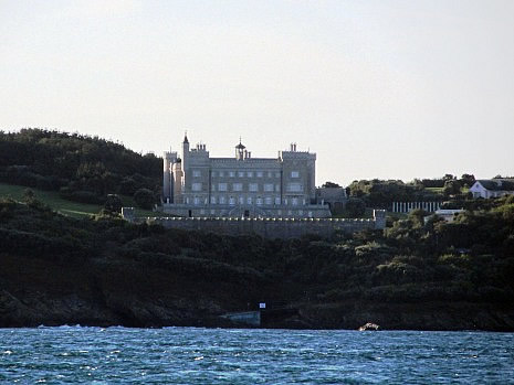
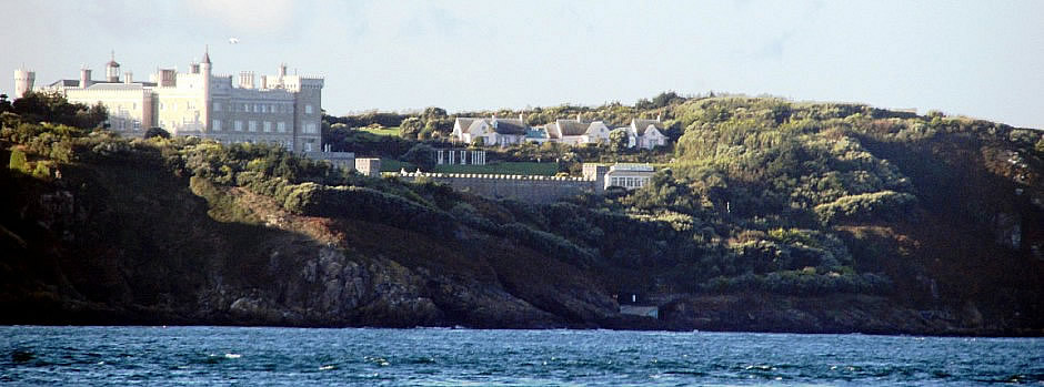
Some visitors arriving by boat may notice a substantial private property on the island of Brecqhou, which sits, almost hugging the western side of Sark. This mock-Gothic castle (shown above) is home of twin brothers Sir David Rowat Barclay and Sir Frederick Hugh Barclay. With a net worth of £6.5 billion (estimated, 2015) and not to be confused with the British banking and financial services company, they have big business interests in areas including media, retail and property. In 1993, the Barclay brothers bought the tenement of the island of Brecqhou (rather handy for tax reasons) and decided to build a substantial home here. Their property on Brecqhou has three foot thick granite walls, fortifications, a helicopter pad and a couple of swimming pools. Since their purchase of the tenement, the brothers have been involved in a number of legal disputes with the government of Sark, including over use of motor vehicles, inheritance laws and property tax. They have also expressed a desire for Brecqhou to be politically independent from Sark.
References and Further Reading
1. Sark Tourism 2016 Official Map
2.
Channel
Islands. Basingstoke: Pub. Division, Automobile Association, 1987.
Print.
3. LaTrobe Foster, Geoffrey and Leslie LaTrobe Foster. La Trobe
Guide To Sark. Print.
4. Sark Tourism
Here
5. Sark on Britannica
Here
6.
Sark on Wikipedia
Here
7. Sark Shipping Company
Here (ferries from
Guernsey)
8. Manche Iles Express
Here (ferries from France via Jersey)
9. Barclay Brothers on Wikipedia
Here
Back to Top