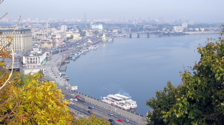
Kiev (or Kyiv) is the capital and largest city of Ukraine and lies in an Oblast (province) bearing its name in the north central part of the country. The central part of the city is located on hilly terrain overlooking the Dnieper River and is a major industrial, transport, and cultural centre. Kiev is a beautifully laid out city with plenty of parks and historical buildings; the oldest parts of the city on the right bank overlooking the river includes a number of interesting churches and monastic structures, the remains of ancient castles and fortifications. In contrast, the left bank of the river is characterised by much flatter terrain and consists of newer quarters which were mostly built after the Second World War.
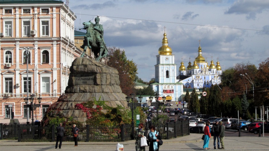
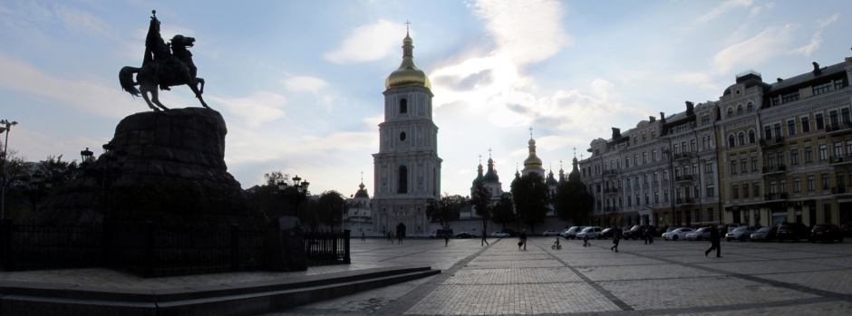
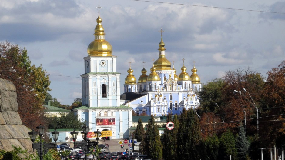
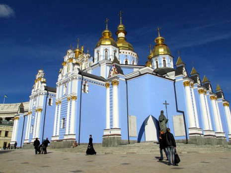
View towards St. Michael's Monastery from Saint Sophia's Square
Known as the Mother of Russian Cities, Kiev is thought to have likely been settle during 4th century AD, although was officially founded in 482AD. It soon developed as an important commercial, cultural and religious centre, bolstered by its strategic position and location on a major trade route. In 882, the city was captured by the Varangians led by Oleg, who made it the capital of Kievan Rus. In 988, during the reign of Vladimir I (St. Vladimir), its inhabitants adopted the Greek Orthodox faith, and the Kiev became the first centre of Christianity in Russia. Being on the edge of the Russian lands meant the city was prone to attacks from outsiders; Mongol armies, led by Batu Khan, sacked and destroyed the city in 1240 and it remained under Mongol domination until the 1360's, when it came under Lithuanian rule. In 1482, it was invaded by Crimean Tatars and in 1569, it was incorporated into Poland. A Cossack revolt against Polish rule in 1648, led to the Kiev becoming the capital of a short-lived independent Ukrainian state. However, in 1686, the city was annexed by Russia. By the 1700's, the city was heavily fortified and the next century witnessed growth as a centre for trade and industry. During the First World War, the city was occupied by German Troops and it witnessed a great deal of fighting following the Russian Revolution. In 1934, Kiev replaced the city of Kharkov as the capital of the Ukrainian Soviet Socialist Republic. During the Second World War, the city was once again occupied by the Germans (from 1941 to 1943). During this period, it suffered heavy damage and as many as 200,000 inhabitants were killed. From the post-war years onwards, the city was rebuilt and once again became one of the chief Soviet centres for trade, industry and culture. When the USSR was dissolved in 1991, Kiev became the capital city of independent Ukraine.
The Dnieper River
Today, Kiev has a population of approximately 2.9 million. It has several universities (perhaps the most famous being the Kiev National Taras Shevchenko University) and is also home to a large number of museums, galleries and sporting venues of national significance. It is served by a metro system, which due to the surrounding terrain, can run either above ground, or very deep underground in places.
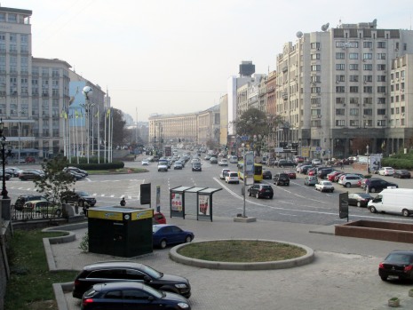
The photographs on this webpage were taken during a trip to Kiev in 2015, 17 years on from a previous visit. A link to a page containing text and photos from the earlier trip in 1998 may be found Here. Whilst much of the city in terms of landmarks, sights and architecture remain unchanged, with the exceptions of new developments including in infrastructure, one of the most striking differences, perhaps not noticed by those more familiar with using its streets on a daily basis, was the increase in vehicle traffic. Where previously, there was largely a more subtle trickling of Ladas with the occasional other make of car steadying its way through the streets, today, the sheer volume of more modern higher performance cars, makes the city, particularly from a pedestrian’s perspective, more akin to any city found in Western Europe, a trend seen in many other Eastern European countries over the last few decades. That said, I found Kiev’s metro system still by far the most convenient way to get around, even though it can become a tad crowded at times. Some of the highlights seen in the photos below are also briefly described and in terms of covering all of the main sights Kiev has to offer, this webpage is not exhaustive; whether it is for business or pleasure, art or science, afternoon strolls in the parks, or the trendy nightlife, I am sure the visitor will find many other points of interest, depending on his or her particular preferences and time available.
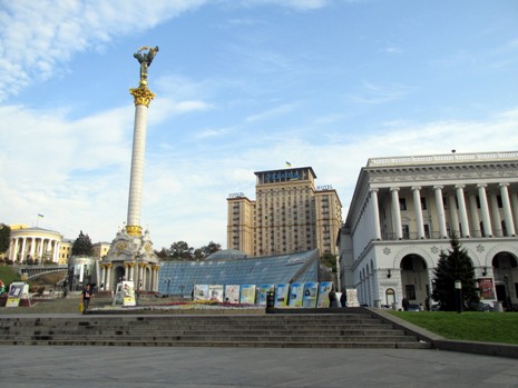
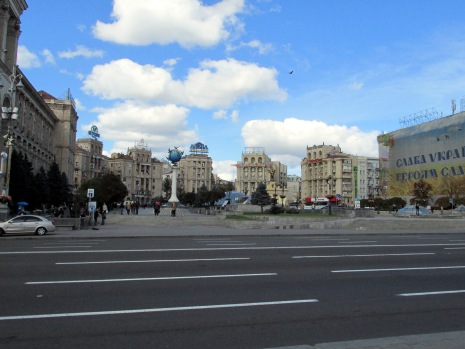
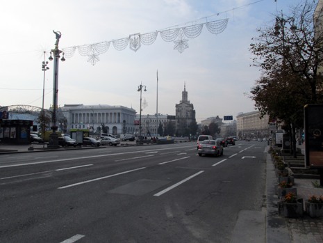
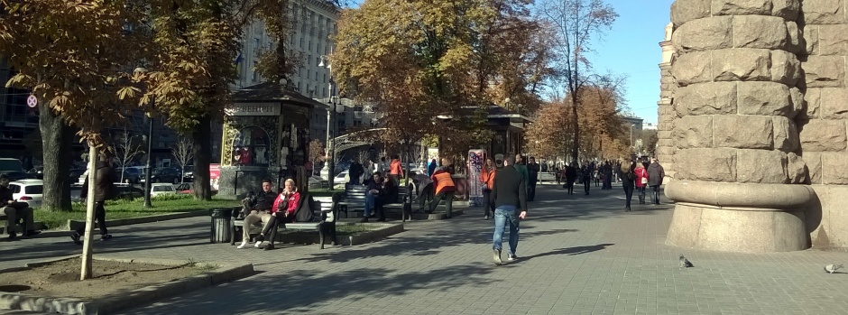
Majdan Nezaležnosti and Khreshchatyk
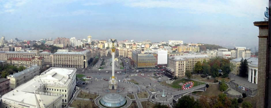
A composite image showing Majdan Nezaležnosti, as viewed from one of the rooms in the Hotel Ukrayina
Majdan Nezaležnosti (Майдан Незалежності), literally meaning "Independence Square", is the national public square of Ukraine. It is one of three squares located along Khreshchatyk, the city’s main central street, and located close to the north-eastern end of the thoroughfare. Khreshchatyk, itself, splits the square in half, whilst several other roads lead in and out of it. Most of the buildings around here suffered heavy damage during World War Two, and today it forms the centre of public performances and political activity. Beneath the square is a metro station and a number of pedestrian routes characterised by small retail outlets for the passers-by.
The square received its current name in 1991 in the when Ukraine became Independent from the former USSR. Prior to that, it underwent several name changes, including, amongst others, Khreshchatyk Square (from 1869), Soviet Square (from 1919) and Square of the October Revolution (from 1977).
 |
 |
|
 |
 |
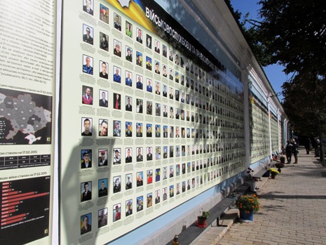
For a history of the square from it’s earliest days, a link to the Wikipedia page is provided Here. And so, the history of Independent Ukraine is comparatively short and many events that took place on Majdan Nezaležnosti have played a significant part of it. The square, commonly referred to as just "Maidan", was the site of pro-independence protests in the 1990's and the Orange Revolution in 2004. However, a much more significant event on Maidan was the Revolution of Dignity (or "Euromaidan") in the winter of 2013-14. During this time, the square became an urban guerrilla camp besieged by government forces. Memorials to fallen revolutionaries can be seen on vul Instytutska, a road leading from the square, serving as a reminder of this relatively recent event [bottom right photo, above]. During Euromaidan, the square was filled with army tents and field kitchens and covered in smoke from burning tyres. A wave of demonstrations and civil unrest had started and the revolution effectively began on the night of 21st November 2013 with public protests to demand closer integration with the European Union. The protests originated at the point where the Independence Monument stands (see below).
 |
 |
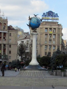 |
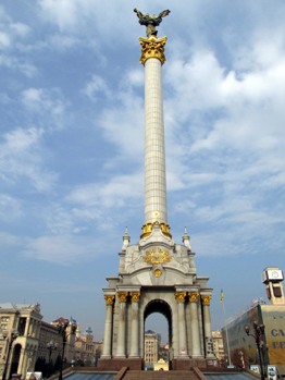
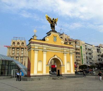
Above: (Left to Right) the Independence Monument, the Lach Gates and the Winged Globe
Formerly the square featured a number of monuments, which included a bust to Karl Marx and the Monument to the Great October (Lenin). As a result of the nation’s late 20th century history these were removed and today, monuments on the square include the Independence Monument - an imposing 61m/200 foot high victory column which was erected in the compositional centre of the square to mark the 10th Anniversary of the independence of Ukraine in 2001, featuring a figurine of a woman (Berehynia) with guelder-rose branch in her arms, the Lach Gates, which were constructed in 2001 to commemorate one of the Medieval Kiev city gates, featuring a sculpture of Archangel Michael, the city’s symbol, at it’s top and a monument/marker called "The Winged Globe", which marks the Kilometre Zero of Ukraine.
 |
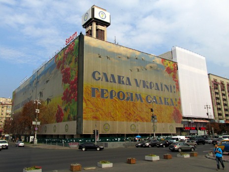 |
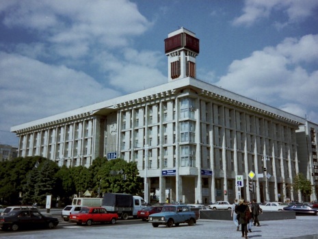
Above: The Trade Unions Building as seen on the page author's visits in 1998 (left) and 2015 (right)
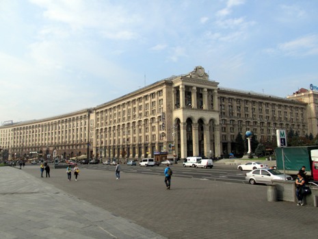
Landmark buildings on the square include the Hotel Ukrayina (which became a makeshift hospital at the peak of the Euromaidan clashes in December 2014), the Tchaikovsky National Music Academy of Ukraine, the Savings bank of Russia, the Main Post Office and an underground shopping centre. Also on the square is the Trade Unions Building, a large office building which features the city's main clock tower. During the ongoing Euromaidan protest campaigns, this building was occupied by the protesters and turned into their main centre of operations. A number of notable Euromaidan events took place in and around the building, including recurrent attacks and provocations by police. On the night of 18th February 2014, the building was completely burnt down and on the 20th February, mass sniping fire took place here. Consequently, the heavily damaged building has been covered with large canvas screens on two sides, bearing the words "Glory to Ukraine". For the reader interested in learning more about the Euromaidan Revolution, I have included a link to the Wikipedia page Here.
 |
 |
|
 |
 |
|
 |
||
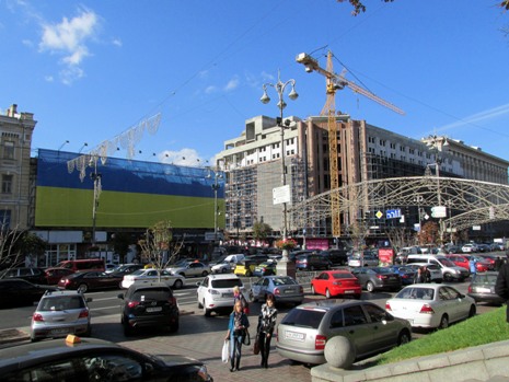
The photos above show Khreshchatyk (Хрещатик), the main street of the city, which stretches some 1.3km (0.81 miles) in length. It runs from the European Square at its north-eastern end down to Bessarabska Square at its south-western end. Despite having a large number of business and administration offices, it is a popular attraction for tourists and shoppers. During World War Two, retreating Red Army troops completely destroyed it's buildings. The whole of the street was subsequently rebuilt in the neo-classical style of post-war Stalinist architecture. Notable buildings on the street include The International Convention Centre "Ukrainian House" (shown top-right, above, and the largest international exhibition and convention centre in the city), Kiev City Council/Kiev City State Administration offices, the main Post Office, the Central Department Store, the Ministry of Agrarian Policy, the State Committee of Television and Radio Broadcasting and at its south-western end is the indoor Besarabsky Market.
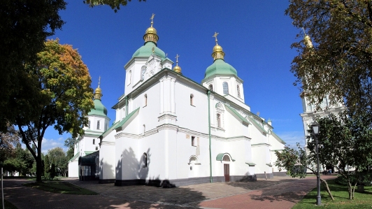
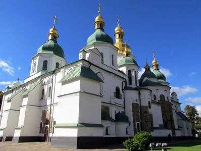
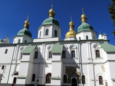
Saint Sophia's Cathedral Complex and Saint Sophia's Square
 |
 |
|
 |
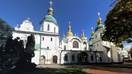 |
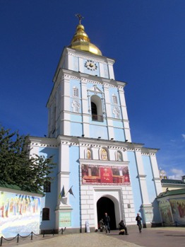
Kiev was one of the foremost religious centres of Russia, and several important old church buildings survive. Probably the most famous of these is to be found in the National Conservation Area of St. Sophia of Kiev, one of the largest museum complexes of Ukraine. At its heart lies St. Sophia Cathedral [shown above], the most significant building of the museum and a masterpiece of architecture and monumental art. With it's notable frescoes and mosaics, it was designed to rival Hagia Sophia in Constantinople, thus symbolising the 'new Constantinople', capital of the Christian principality of Kiev. St. Sophia's cathedral is the oldest in Ukraine and was founded the 11th century, in a region which was evangelized after the baptism of St. Vladimir in 988. It was largely rebuilt in the 17th and 18th centuries and is now a museum. It is surrounded by a complex of 18th century monastic buildings which represent the style of Ukrainian Baroque. Built originally of wood in 1633, the buildings were destroyed by fire in 1697 and reconstructed in stone. In 1990, St. Sophia Cathedral and the architectural ensemble of monastic buildings were inscribed on the list of UNESCO World Heritage Sites.
The thumbnail photo gallery above shows some more detail to be found within the walls of the ensemble (click on images to see a larger size). The Bell Tower of St. Sophia Cathedral is shown in the gallery (photos 1-3). It is built in the Ukraine Cossack Baroque style and one of the symbols of both Kiev and the Nation. Funded by Hetman (the highest military officer) Ivan Mazepa, the bell tower was originally built from 1699-1706 and rebuilt from 1744-1748 by the project of Gottfried Johann Schädel. The fourth tier of the tower was built by the design of architect P. Sparro from 1851-1852. The most recent restoration of the bell tower took place from 1997-2003, after which it was opened to the public for the first time in a few decades. Other buildings in the complex (all 18th century) include The Refectory [Photo 8], The Metropolitan's Residence [Photos 6,7], The Bakery (The Consistory), Zaborovskiy Gate, The South Entrance Tower, The Cells of the Cathedral Elders and The Seminary [Photo 9]. Also here is the 20th century House of the Diocesan School Council [Photo 10, to right].
 |
||
 |
 |
|
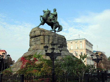
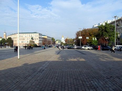
Outside of the complex through the entrance running through the Bell Tower lies Saint Sophia's Square (shown above). Formerly the city's main square, it creates an axis that unites St. Sophia's Bell Tower with that of St. Michael's Monastery. One of the main features of the square to be seen today is the Bohdan Khmelnytsky Monument (above, left). One of the oldest in the city, this sculptural monument was built in 1888 and is dedicated to the Hetman Zaporizhian Host Bohdan Khmelnytsky. It was here in 1648, that the city's residents met Khmelnytsky, who was leading his Cossacks' regiments by entering the city through the Golden Gates not long after the victory over the Polish Army at the battle of Pyliavtsi.
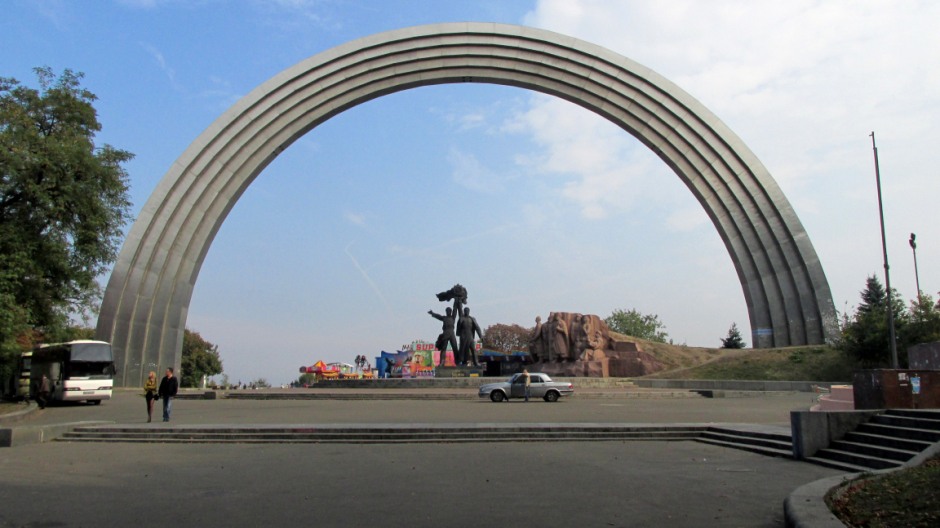
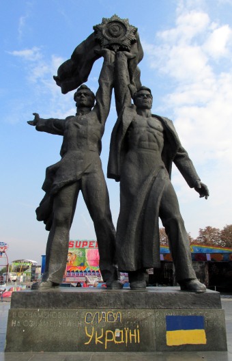
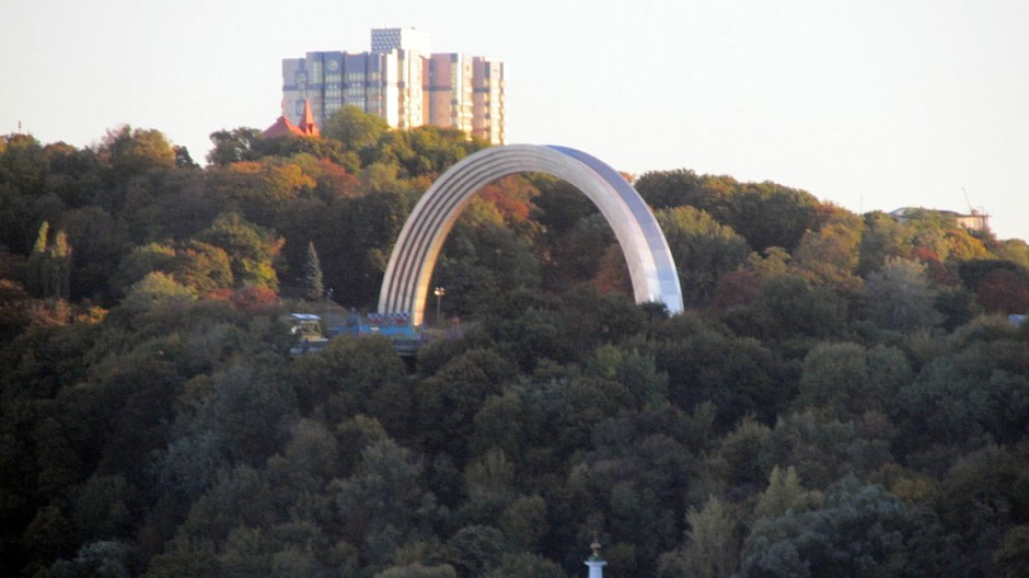
People's Friendship Arch/Arch of Diversity
 |
||
 |
 |
|
 |
||
The above photos show the Friendship of Nations Arch, as it was known during the author of this page's visits to the city in 1998 and 2015; it is now known as the "Arch of Diversity". The titanium structure, measuring 50m (164ft) in diameter and dedicated to the unification of Russia and Ukraine, was opened on November 7th 1982 to commemorate the 60th Anniversary of the USSR and the celebration of the 1,500th Anniversary of the city of Kiev. However, in May 2016, as part of its de-communisation policy, the Ukrainian government announced plans to dismantle it. The plans are to replace it with a memorial dedicated to veterans of the War in Donbass. For the 2017 Eurovision Song Contest (coincidentally at the time of writing this), it was temporarily painted into a rainbow and renamed the" Arch of Diversity" with it also becoming a symbol of the Kyiv Pride parade - a true sign of the times. Although the structure is impressive, arch or no arch, there's no escaping the fact that from this particular spot, located not far from the north-eastern end of Khreshchatyk, there is an excellent view of, and over the river, extending towards the eastern side of the city where the expansive forests and the outer suburbs sprawl out for miles.
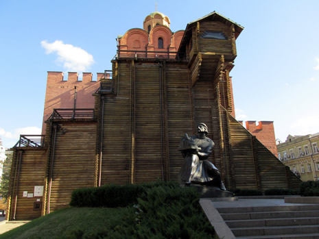
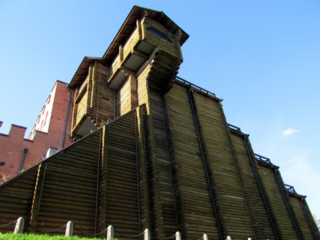
The Golden Gate
 |
 |
|
 |
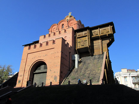 |
The photos above show Kiev's Golden Gate - a reconstructed building on the site of what was once the main entrance to the city. The Golden Gate was the main gate in Kiev's 11th century fortifications, when it was the capital of Kievan Rus'. Located on the corner of Volodymyr street and Yaroslaviv Val Street, the original gate was named in imitation of the Golden Gate of Constantinople. The structure was taken down sometime in the Middle Ages, leaving minimal traces of its existence. In 1982, the Soviet authorities reconstructed it, despite having no images of the original structure to work with, only an idea based on remains of the walls. And so, the reconstructed Golden Gate seen today, attractive it is, remains tentative with respect to looking like the original. The main purpose of rebuilding it in 1982 was in marking the 1500th anniversary of Kiev's founding. Inside the gate is a branch of the National Sanctuary "Sophia of Kyiv" museum. For more information on Kiev's Golden Gate, click Here (external link).
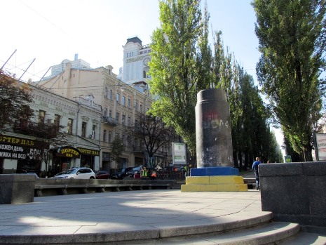
Statue of Lenin
Further up the page, it was mentioned that one of the differences observed with this visit to the city in 2015 compared with an earlier visit in 1998 was the increase in road traffic. Another (and perhaps much more symbolic) difference seen was at the site of Lenin's Statue; in December 1946, just after the end of the Second World War, a red granite, 3.5-metre high statue of Vladimir Lenin, was constructed. On June 30th 2009, the nose of it and part of the left hand were destroyed, although the Communist Party of Ukraine arranged for its restoration and it was re-unveiled later that same year. However, on December 8th 2013 , during the Euromaidan protests in Kiev, the statue was toppled and destroyed. And so, with reference to the plinth, below left is a photo I took in 1998 and below right is a photo from a similar viewpoint taken in 2015:
 |
 |
St. Michael's Golden-Domed Monastery
 |
||
 |
 |
|
 |
 |
The photos above show St. Michael's Golden-Domed Monastery. It is located on the right bank of the Dnieper River and is just northeast of St. Sophia's Cathedral Complex. This functioning Ukrainian Orthodox monastery was originally built in 1108 by Prince Sviatopolk. As well as the main St. Michael's Golden-Domed Cathedral, the monastery includes the Refectory of St. John the Divine (built 1713), the Economic Gates (1760) and the Bell Tower (circa 1716-1719). During the 18th century, the monastery's outside was rebuilt in the Ukrainian Baroque style, although the inside was kept in it's original Byzantine style. The Cathedral was brutally demolished in 1934-1935 by the Soviet regime in connection with construction of the government centre and for having "no historical value". Fortunately, some of the cathedral's valuable frescoes and mosaics were saved; they were re-housed in Moscow's Tretyakov Gallery and the State Russian Museum in Leningrad (now Saint Petersburg) and have subsequently been returned. Following Ukraine's independence in 1991, the cross-domed cathedral, with it's three naves, was beautifully reconstructed and this was completed in May 2000. The building's sky-blue exterior and shining golden domes add a very desirable layer to the cityscape of Kiev.
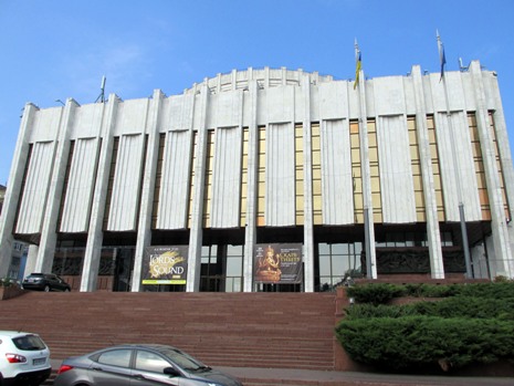
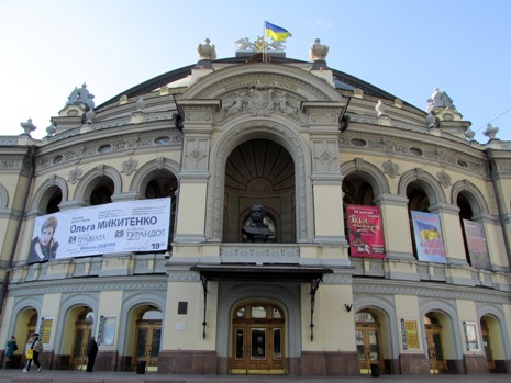
Kiev National Academic Theatre of Opera and Ballet
 |
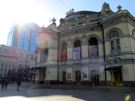 |
The photos above show the Kiev National Academic Theatre of Opera and Ballet. The building is situated on the crossroads of Volodymyrska Street and Bohdana Khmel'nyts'koho Street, in the historical part of the city. The building was constructed in 1901, on the site of the city theatre, which suffered a catastrophic fire in 1896. It was designed by Victor Shreter, a professor of architecture from St. Petersburg, who's plans were the winner of a competition which saw entries from over 20 architects from half a dozen or so countries. At the time of it's completion, the Opera House was a very impressive building, with capacity for an audience of 1650 in an interior predominantly of velvet and bronze decor. The chairs, chandeliers and lamps came from Vienna. Originally above the main entrance was a picture of Archangel Michael, the city’s symbol, although it was removed after objections of having a divine figure on such a building, and replaced with a composition of griffins holding the lyre, the musical art symbol. In the 1980's, the theatre was renovated, having suffered damage earlier on in World War Two. For more detailed information, click Here (External Link).
Saint Andrew's Church
The thumbnail gallery below shows photos of the exterior and interior of Saint Andrew's Church. It is located in, and overlooks, Podil - one of Kiev's oldest neighbourhoods and is sited on a steep hill (Andriyivska Hill), which is named after it. A major Baroque church, often mistaken for a cathedral, it was constructed from 1747–1754 to a design by the Italian architect Bartolomeo Rastrelli, who's other works include the famous Winter Palace in St. Petersburg. The church was built to honour Saint Andrew who is recognized as the "Apostle of Rus". He is believed to have come to the slopes of the Dnieper River in the 1st century AD and placed a cross on the location of the church. He is also said to have prophesised that the sparsely inhabited area would one day become a great city. Not only does the church have a stunning Baroque exterior, but it is worth the walk up the hill to go inside to see the interior, where there are countless magnificent paintings and sculptures to be seen. The preservation of the church, however, has been an ongoing issue, due to concerns with the stability of the ground at it's hilltop location. The building is part of the National Sanctuary "Sophia of Kiev" as a landmark of cultural heritage and for further information on it's history, an external link to the Wikipedia page can be found Here. Photography inside the church is only possible by obtaining a permit for a modest fee.
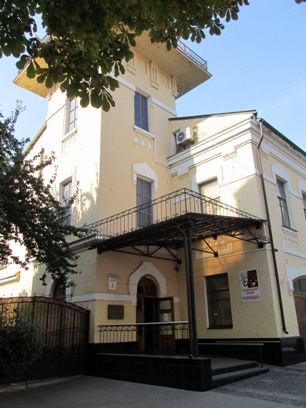
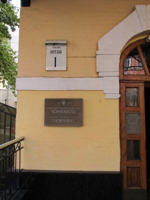
Ukrainian National Chornobyl Museum
 |
 |
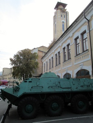 |
The photos above show the outside of the Ukrainian National Chornobyl Museum, which is located at 1 Khoryva Lane (provulok Khoryva, 1), in the city centre's historic Podil neighbourhood. This website includes a separate webpage on the museum, to be found Here (or click on either of the photos above).
☢ In addition, for the reader interested in the Chernobyl Exclusion Zone itself, a page on this website containing a considerable number of photos and text from a visit inside this fascinating area may be found Here.
Arsenalna Metro Station
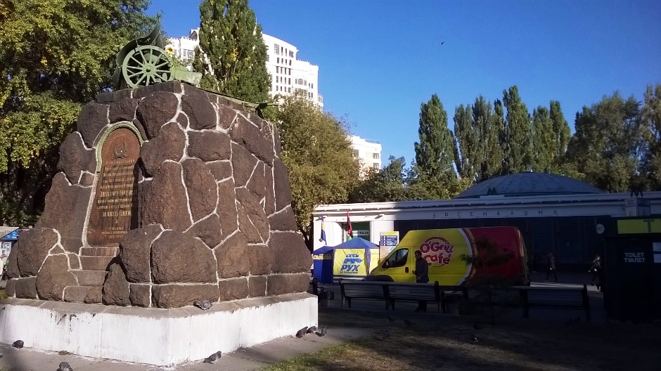
The photo above shows the outside of Arsenalna (Арсенальна) Metro Station, which is located a couple of kilometres east and slightly south of the city centre. It is the deepest in the world at 105.5 metres. Basically, you traverse one escalator, thinking you have just been on the longest subterranean moving staircase ever in your lifetime, only to turn a corner and find yourself traversing on an equally long ride. In total, the escalator rides at Arsenalna metro station take approximately four to five minutes each way. The reasons behind all this is Kiev's geography. The station is situated just beyond a high bank of the river which rises above the rest of the city. The metro line itself crosses the river over a bridge, so despite being the deepest metro station in the world, it isn't far from Arsenalna where the line isn't underground at all. Arsenalna was opened in 1960 and is among the first of the metro stations to be built in the city. It is named after an arsenal factory located nearby. As for the escalators, it was unclear whether photography is permitted on the metro system or not for security reasons, and so here is an external link, where someone has posted video of the ride on YouTube Here.
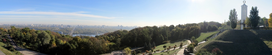
Park Vichnoi Slavy
 |
||||
 |
 |
 |
||
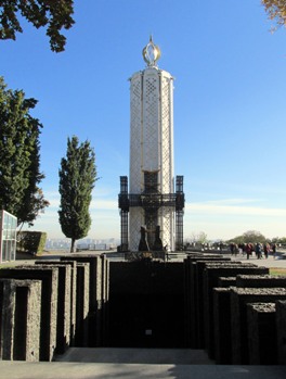
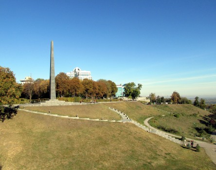
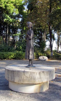
Near the exit of Arsenalna Metro Station lies part of a 3km long park system that runs along the western bank of the Dnieper River. To the southeast lies Park Vichnoi Slavy (Glory Park), which is shown in the photos above. More precisely, the park is named "The Park of Eternal Glory to the Soldiers of The World War II" and forms a memorial complex. Monuments dedicated to those who gave up their lives whilst protecting their Motherland are sited throughout the park and these include The Glory Obelisk (lower middle photo, above) which was installed in 1957 with a grave of an unknown soldier at the base, the Eternal Flame and in more recent times, the monument to the Victims of Starvation Times 1932-33 (lower left photo, above). The latter is otherwise known as the Memorial to Holodomor victims and was opened in 2003 (and sanctified in 2008). During the years 1932-33, as many as 10 million Ukrainians perished as a result of a famine orchestrated in part by the Soviet leadership in an attempt to squash the peasantry. The lower right photo above shows a poignant statue close-by, known as the Bitter Memory of Childhood. At Park Vichnoi Slavy, the visitor is presented with not only great views of the river, but beautifully laid out tree and shrub-lined walkways that give views of the golden cupolas of the upper part of, and eventually lead on to, Kyiv-Pechersk Lavra, the Monastery of the Caves, featured next on this webpage.
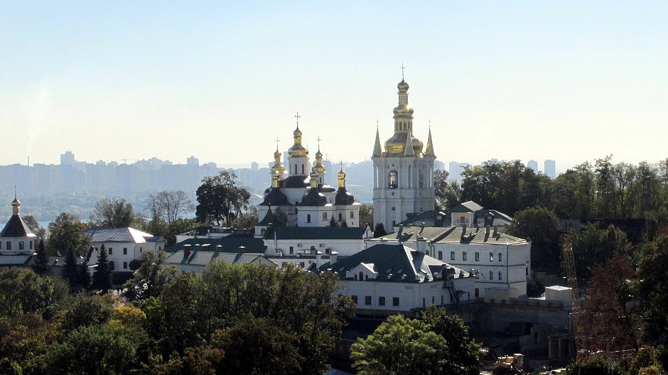
Monastery of the Caves (Kyiv-Pechersk Lavra)
The large Pechersk Lavra, or Caves Monastery was founded by St. Anthony in 1051 and is perhaps one of the most important monasteries of the Kievan Rus period (882-1240 AD). It is located in the southern part of the city and overlooks the curving Dnieper River high up atop it's western bank. The monastery's buildings and caves are positioned on two hills and the valley between them. It developed as a site of both religious and military importance and the name came from the Ukrainian word 'pechery', which means 'cave'. St. Anthony was born in Liubech, north of Kiev, and entered monastic life at Mount Athos, before returning to his homeland. The natural caves found here made an ideal site for the Orthodox monk and his follower, Theodosius, where they founded the Monastery of the Caves. The monks lived and worshipped in underground cells carved from the caves which were also used as burial chambers. Pechersk Lavra has historically been one of the main spiritual centres of the Orthodox Christendom and for centuries pilgrims have come here. Approaching the monastery from the direction of the city centre, the upper part of Pechersk Lavra is shown in the thumbnail gallery below.
Overall, there are 40 buildings in the monastery's complex, including churches, museums and libraries. Churches here include the Trinity Gate Church, the Assumption Church, All Saints Church and the Refectory Church and these are mainly built in the Byzantine and Ukrainian Baroque styles. One of the site's landmark structures is the Great Belfry (built 1731-1744), which stands 97m (317 feet) tall, making it once the tallest building in the whole of Russia. Museums here include the Museum of Ukrainian Decorative and Applied Art, the Museum of Historical Treasures and the Museum of Ukrainian Books and Printing. On a more contemporary note, one museum within the walls of the complex visited on this particular trip, was the Mykola Syadristy Microminiatures Museum. Although not particularly religious in theme, it is worth a visit to see the works of Mykola Syadristy, which are all so small, they have to be viewed through optical magnifiers. Amongst other works, they include the words “Long Live Peace” in Ukrainian engraved on a human hair, miniscule portraits, a chess set on a pin head and what is believed to be the world’s smallest book.
Back to the more serious aspects of the burials, the caves of the Pechersk Lavra 's lower part include the remains of many important historical and religious figures. It is possible to see the monk's naturally mummified remains and this involves an often crowded walk through the underground labyrinths, holding a candle to guide the way. This religious and solemn experience can certainly be moving for many, if not unforgettable for others. Photography within the lower part of Pechersk Lavra is prohibited and so below is a photograph overlooking it from the upper part:
Whilst during the Middle Ages, the monastery became the centre of Orthodox Christianity in Kievan Rus, it also played a significant cultural role in the Slavic state. In 1615, Ukraine's first printing house was established here but, like much of the city, the monastery was destroyed during the Mongol invasion. However, in the following centuries, it was rebuilt and enlarged with fortifications. Immediately prior to the Russian Revolution in 1917, Pechersk Lavra housed over 1,200 monks and novices. However, after the revolution, the monastery was closed by the Communist government, nationalised, and transformed into a cultural historical museum (of "Religious Cults and Way of Life"). By 1929, monastic life here had come to an end. During World War Two, the site was occupied by Nazi troops who installed anti-aircraft guns within the strong, well positioned, fortified walls. In 1941, a bomb exploded in the Assumption Church, leaving it in ruins - It is unclear which side planted the bomb. In 1987, as a result of Soviet leader Mikhail Gorbachev's Perestroika ("Openness") movement, the accompanying religious revival within the USSR enabled the returning of the monastery from the Soviet government to Ukraine's Orthodox Church and today, once again, the monastery is a place of worship.
Motherland Monument
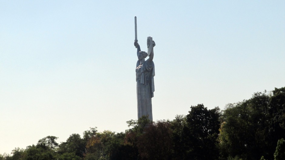
The photograph above shows the 62m (203 foot) high Motherland Monument. It is a part of the Museum of The History of the Great Patriotic War (World War Two) and stands upon the museum building. The statue's right hand holds a sword, whist the left hand holds a shield with the State Emblem of the Soviet Union. Although in 2015, the Ukrainian parliament outlawed symbols of the Soviet and communist era, World War Two monuments are exempt from this. The museum itself is one of the largest museums in Ukraine with over 300,000 exhibits in an area of 10 hectares. The memorial complex opened in 1981, to commemorate the German-Soviet War of 1941-1945. As wall as the Motherland Monument, popular exhibits include "The Flame of Glory", a site with World War Two military equipment and the "Alley of the Hero Cities".
Text: May 2017
References and Further Reading
1) In Situ Public Information Signs
2) Hodges, Linda, and George Chumak.
Hippocrene Language And Travel Guide To Ukraine. New York: Hippocrene
Books, 1996. Print.
3) In Your Pocket Kyiv (Kiev) City Guide - A free
indispensible guide to Kiev from the popular series and downloadable
from their webpage
Here
4) Johnston, William M. Encyclopedia Of
Monasticism. 1st ed. London: Fitzroy Dearborn, 1999. Print.
5) Noble,
John, and Ryan Ver Berkmoes. Russia, Ukraine & Belarus. Hawthorn, Vic.:
Lonely Planet, 2000. Print.
6) Otfinoski, Steven. Ukraine. New York,
N.Y.: Facts on File, 1999. Print.
7) Ring, Trudy, Robert M Salkin, and
Sharon La Boda. International Dictionary Of Historic Places. 1st ed.
Chicago: Fitzroy Dearborn Publishers, 1995. Print.
8) Savchuk, Galina,
Simon Hemans, and Raymond Asquith. The Streets Of Kiev. Kiev: ArtEc
Publishers, 1996. Print.
9) "Kiev". En.wikipedia.org. N.p., 2017. Web. 7
May 2017.
10) Kiev: Saint-Sophia Cathedral and Related Monastic
Buildings, Kiev-Pechersk Lavra on the UNESCO website
Here
Back to Top