Coober Pedy and The Breakaways
Coober Pedy
Coober Pedy is a town in the dry, barren desert of South Australia on the Stuart Highway, 846km north of Adelaide. It is sometimes referred to as the "opal capital of the world" because of the sheer number of opals mined in and around the settlement.
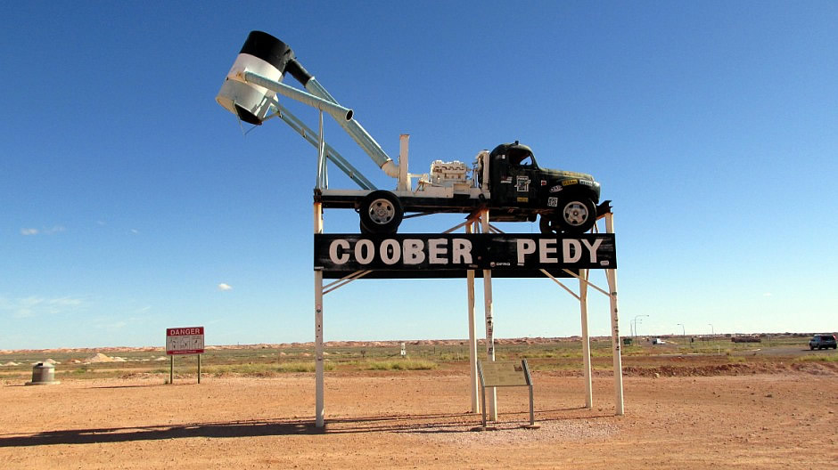
Above: The town sign features a truck fitted with a 'blower'. The blower is a distinctive feature of the landscape around Coober Pedy. It is, in essence, a giant vacuum cleaner which sucks dirt out of the mine shafts from up to 30 metres below ground, dumping it on the surface.
The town is known for it's underground dwellings, as well as other amenities and services, including several churches. These "dugouts" are below ground because of the extreme temperatures found here with days in the summertime at 50°C and subzero night-times in winter.
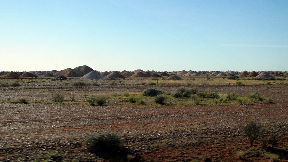
Approaching Coober Pedy along the Stuart Highway in the light, the first sight visible across the landscape is a significantly high number of piles of dirt, a sample of which is shown above; they have come from thousands and thousands of opened up opal mine shafts. These holes in the ground present a serious risk of people falling into them and indeed, there are signs up warning people not to step backwards and the advice is to take such care especially when taking photographs. The town has a population of around 1700, including 275 indigenous Aborigines and some 44 nationalities represented (District: 3,500 total). As well as attracting opal prospectors, the town also attracts tourists and, interestingly, filmmakers.
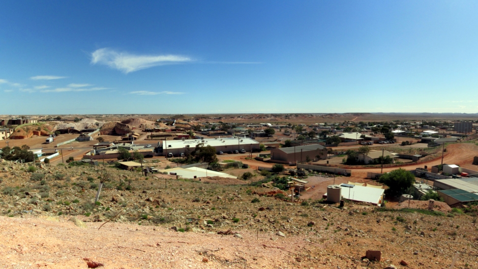
Above: Panoramic stitch of a section of the town from the Big Winch Lookout
The name "Coober Pedy" comes from the local Aboriginal term kupa-piti, which means "boys’ waterhole". Although Aboriginal people have had connections with the area for 1000's of years, it wasn't until 1858, when the first European, the explorer John McDouall Stuart, passed near the site of the town we see today. Opal was discovered here in 1915, when a young 14 year old, William ('Willie') Huchinson, came across it. He was the Son of Mr Jim Huchinson who, with others, was in a syndicate, (unsuccessfully) prospecting for gold. The opal discovery led to miners moving here in 1916 and the beginnings of the town. Since then, Coober Pedy has been supplying most of the world's gem-quality opal - currently there are some 70 plus opal fields here. Large-scale mining here was discouraged by a law allowing each prospector a 165-square-foot claim - the claims can be seen above ground, individually marked out.
The tourist industry now also plays a very important role in the town's economic sustainability and there are a number of attractions for the visitors who come here. It is possible to visit a small number of the hundreds of working mines around here, such as Tom's Working Opal Mine and Old Timers Mine, whilst tour operators and locals offer a chance to go 'fossicking' (non-commercial rock, mineral or crystal extraction up to a depth of one metre) or to 'noodle' through a claim by way of sifting through their waste piles of excavated stones. It is illegal to 'noodle' , or indeed go on a pegged claim without the miner's permission, although for the more optimistic visitor, there is a public 'noodling' area [Photos 36 & 37, above].
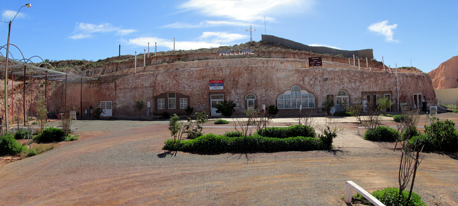
Above: Panoramic stitch showing Coober Pedy's Serbian Orthodox Church
Dugout homes and churches here include Faye's Underground Display home, the Catacomb Anglican Church, St Peter & Paul Catholic Church and the Serbian Orthodox Church. The latter, shown above [and in gallery photos 38-46] is the largest and most impressive underground church here. Another attraction is the Big Winch Lookout [gallery photos 20-33], from which there are sweeping panoramic views of the town and towards the Breakaways (see lower down the page). As well as some extremely bizarre objects to be seen around town, including rusty car wrecks and various bits of art associated with junk, leftover sets and props from films that have been made here may be seen littered around the place. It goes without saying that the thinking behind some of what is to be seen here has a certain sense of humour and/or abstract thinking behind it. The first tree to be seen in Coober Pedy was welded together from scrap iron and sits on a hilltop overlooking the town.
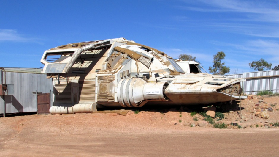
Above: Spaceship from the film Pitch Black which has crash landed outside the Opal Cave Shop . Other films made around the town include Mad Max III, Red Planet, Ground Zero and Priscilla, Queen of the Desert.
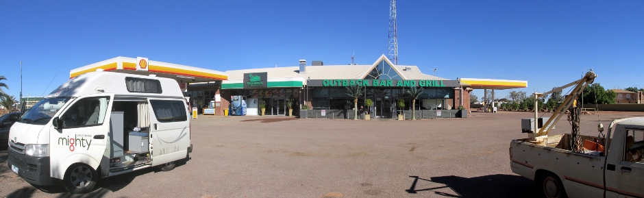
Also to be seen in Coober Pedy is a monument to John McDouall Stuart, the wind Turbine Generator, Boot Hill Cemetery and several museums and galleries (underground, naturally). For golfers, the town's 18 hole/72 par course is something quite different: It is mostly played at night with glowing balls to avoid the heat and as there is no grass, golfers take a small piece of "turf" around to use for teeing off. It is also the only club in the world to enjoy reciprocal rights at The Royal and Ancient Golf Club of St Andrews. The town has modern facilities and amenities, including a wide range of accommodation, both above and below ground, cafes, restaurants a post office and a bookshop.
The Breakaways
The Breakaways Conservation Park (formerly called 'The Breakaways Reserve', or simply 'The Breakaways') is a barren but colourful area of semi-arid desert hills and escarpments 33km away on an unsealed road north of Coober Pedy. The park is located within the Arckaringa and Eromanga (Great Artisan) Basins of Australia, which cover an area of approximately 75,000km² and 1.2 million km² respectively.
Above: Scrollable panoramic stitch of view from the main lookout point
The Breakaways form part of the Stuart Range and are named so because when viewed from a distance, it looks as if the land features have 'broken away' from the higher ground of the escarpment. Management of the park is shared by the Department of Environment, Water, and Natural Resources in conjunction with the Antakirinja Matu-Yankunytjatjara Aboriginal Corporation and the District Council of Coober Pedy. The site is of significance to the Aboriginal people, whose name for the area is Umoona (long life), referring to the unmoona tree, found in the area. Aboriginal people have lived in this area for thousands of years and throughout the park, ancient Aboriginal artefacts, such as stone tools, have been found.
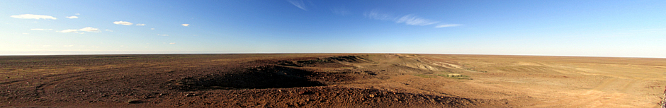
Turning off the main Stuart Highway west of the town, a 70km (mainly unsealed) loop road takes the visitor through the park to see a number of points of interest; the table-like Moon Plain (contrary to what the name suggests) is probably the closest one can ever get to seeing the planet Mars, the Dog Fence (see lower down this page), The Castle which is a white and yellow mesa that featured in Mad Max III and Priscilla, Queen of the Desert, and also the main lookout which extensive views of the stunning landscape seemingly as far as the eye can see. Here, the flat-topped mesas and stony giber desert represent remnants of millions of years, providing a wealth of geological interest. It is difficult to imagine that over 70 million years ago, this area was covered by an inland sea; fossils of sea creatures can be found throughout the area. The main lookout lies near one end of the unsealed loop road, just 5km from the Stuart Highway. The region is surprisingly home to an array of native fauna and flora, which have successfully adapted to one of the world's harshest environments.
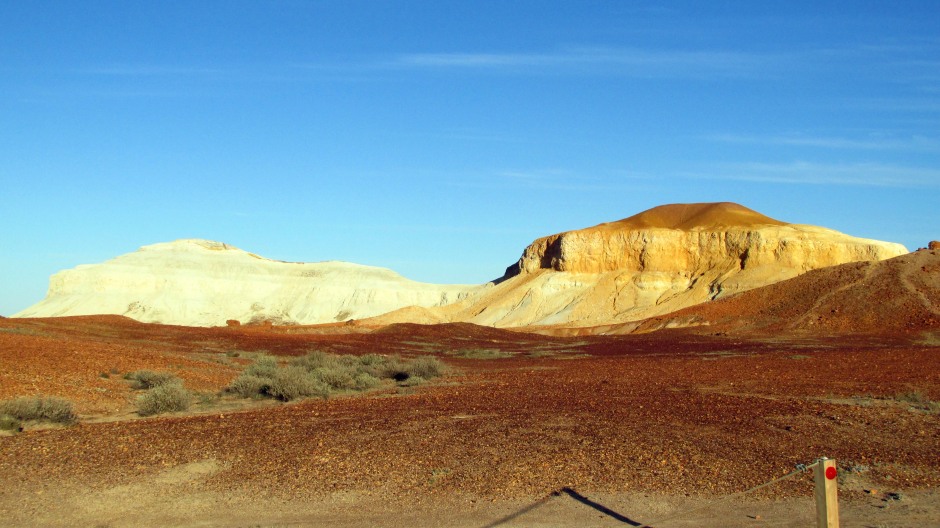
Known to non-Aboriginal people as The Castle (or Salt and Pepper) is a unique landform in The Breakaways, which is shown in the photo above. To the Aboriginal people, it is known as papa or two dogs - it is a brown dog and a white dog sitting down. The difference in colouration of the two hills, although joined, is a result of various stages of weathering and erosion; the brown hill has not weathered as much as the white hill. To the right (coming off the photo above), is a peaked hill, which is the wati, or man, owner of the two dogs.
Permits are required to visit the Breakaways Conservation Park and can be purchased at the Visitor Centre, District Council of Coober Pedy or Underground Books, also in Coober Pedy. Coober Pedy Residents and Antakirinja Matu-Yankunytjatjara Aboriginal people are exempt from requiring them. A conventional 2WD vehicle may be used to complete the loop road, although if it has been raining, a 4WD is required. The climate of The Breakaways is similar to that of Coober Pedy, characterised by cool nights and very hot days (sometimes above 45 °C in summer).
The Dog Fence
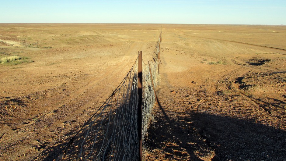
The Dog Fence (Dingo Fence) is an unbroken barrier stretching 5,300km from the cliffs of the Great Australian Blight in South Australia, through northwest New South Wales and across Queensland, terminating in sight of the Bunya Mountains. It is the longest (and perhaps the most famous) fence in the world and was constructed to protect south-eastern sheep country from attacks by Australia's native dog, the dingo. The dingo is a skilled predator and roams north of the fence, feeding on a wide range of animals including kangaroos, wallabies, rabbits, lizards, insects and just about anything it can scavenge. Dingoes have formed very much part of the lives of Aboriginal people, living, eating and hunting with them and feature in stories and in rock art.
When the Europeans arrived, they introduced flocks of sheep which became an easy target for dingos, killing more than they needed for food. In order to protect the sheep (and cattle), individual land owners built fences around their properties. These separate fences became linked into vermin-proof districts with over 30,000 miles of fence in total. After the War in 1946, the single Dog Fence was established and has since been maintained by each of the states. Previously, the fence was patrolled on horseback or camel, checking for breaks made by wildlife or washed away by rain. Traps and poisonous baits were used along the fence, as well as shotguns to keep the dingos at bay. Today, 4WD vehicles are used to patrol the fence and parts of it are electrified using solar power and boxes are laid down emitting high frequency sound. Parts of the fence being washed away by rain are still an issue and so patrolmen have to act quickly to repair any damaged sections as soon as is practically possible. Whilst sheep are kept relatively safe from dingos, south of the fence, the populations of other animals, such as kangaroos, foxes and cats are consequently not kept in check by the predatory dingo. Meanwhile, north of the fence, dingo's themselves are in danger of losing their own unique identities through interbreeding with dogs that have been introduced by the Europeans.
The Dog Fence crosses the Stuart Highway near Coober Pedy, where special cattle grids span the road. As seen on this web page, it runs along the edge of the Breakaways Conservation Park, and sections can be seen running near the unsealed loop road to the main lookout area.
References and Further Reading
1. Exploring the Stuart Highway and Oodnadatta
Track Adelaide to Darwin. Balhannah, SA: Tourist Information
Distributors Australia.
2. In situ public information boards
3.
Rawlings-Way, C., Worby, M. and Brown, L. (2013). Central Australia.
Footscray, Vic.: Lonely Planet.
Back to Top