Hunstanton Cliffs, 27th May 2021
Hunstanton Cliffs are a striking natural feature of the North West Norfolk coastline in the east of England. They form a 11-acre (4.6Ha) biological and geological Site of Special Scientific Interest and also a Geological Conservation Review site. The photographs on this webpage aim to show the cliffs in all their glory and accompanying them is some further descriptive text.
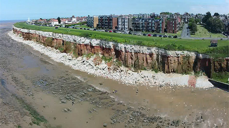
Above: Hunstanton Cliffs (Panoramic stitch created from pan shot taken with webpage author’s brother’s drone)
Hunstanton Cliffs are characterised by their eye-catching, eroding, red and white stripes which run horizontally along their face. These stripes of different coloured rocks were laid down at the bottom of the oceans during the mid-Cretaceous geological period around 100 million years ago. The global climate at this time was much warmer and the sea levels higher than today. The land here was in fact closer to the equator and the climate warmer. Through time, with migrating land masses and changes in climatic conditions, the rocks eventually rose above the sea to form the eroding cliff face seen today. The here is exceptionally rich in Albian ammonite fossils (the Albian being an age within the Cretaceous period). Close examination of the layers of rocks here and the fossilised remains preserved within them has helped with discovering what life was like here all those years ago. For the visitor today, fossil-hunting may seem appealing to some, but attention is drawn to the safety notices regarding the cliffs, bearing in mind that coastal erosion here is far from inactive. The site here is also of biological interest, particularly with respect to the cliff’s colony of breeding fulmars.
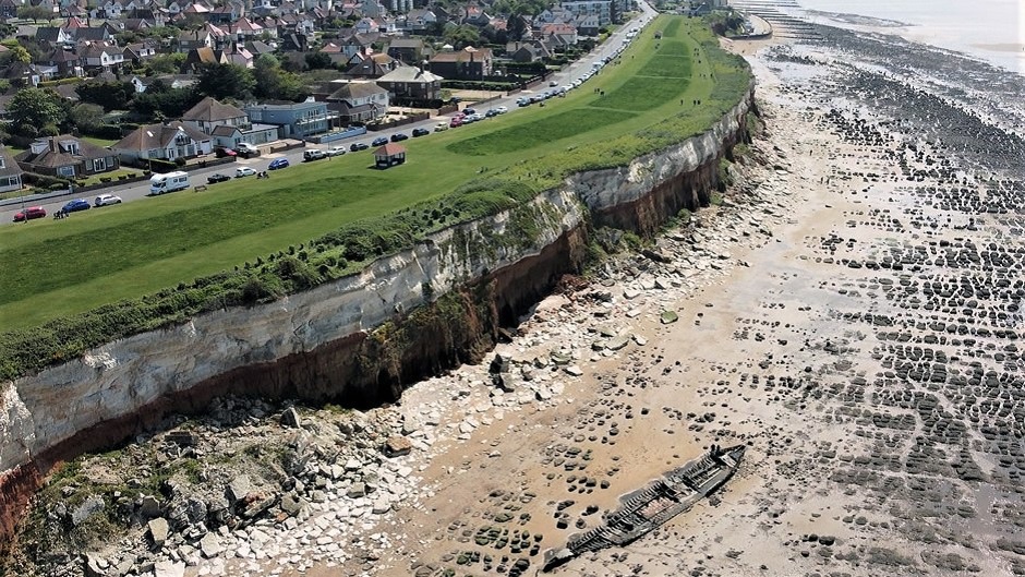
Above: An aerial shot of the cliffs, looking south (Photo taken with drone from video, courtesy of the webpage author’s older brother). Note that in the foreground in the centre can be seen the wreck of the Steam Trawler Sheraton, a fishing-vessel-turned-warship that served in both world wars. Located at Saint Edmund’s Point, she was built in 1907. After WWII, whilst anchored in The Wash in April 1947, high winds caused it to stray from its moorings and the vessel eventually settled on the beach at Old Hunstanton, where its remains can still be seen today at low tide.
The thumbnail gallery below shows more photos of Hunstanton Cliffs, taken during a walk here in May 2021 (click on an image to enlarge). The walk started (and finished) along the cliff top walk, a lovely place to take a stroll, whatever the tide. The cliff top walk was created some time after 1897 when Hamon le Strange, son of Hunstanton’s creator, opened up the land here to the public (Hunstanton began as a purposely-built resort in 1846). Prior to the creation of the cliff top walk, there were fields running down to the cliff edges, with only a narrow path along the cliff top. The cliff top walk not only provides an excellent place to exercise and take in the views of The Wash, it also includes shelters for people to rest and take in the fresh sea air. Today, an accessibility ramp leads from the southern end of the cliff top walk down to nearer the beach, from where a walk south leads to the promenade on Hunstanton’s seafront.
The resort town of Hunstanton itself has a fairly unique position in that despite being on the east coast of Britain, it faces west, and so enjoys spectacular sunsets over the sea. The Wash at this point is approximately 12½ miles wide and during times of clear visibility, it is possible to see some of the landmarks on the opposite coastline of Lincolnshire, such as St Botolph’s Church Tower (‘The Stump’) in Boston, Gibraltar Point, Holbeach air weapons range, wind farms and at night-time, the lights of Skegness Pleasure Beach Holiday Resort.
Back to Top