Introduction
Bahrain is a small island state in the Persian Gulf off the eastern
coast of Saudi Arabia. It is a sheikhdom consisting of the natural
islands of Bahrain (also known as as-Awal), Sitra, Muharraq, Umm an
Nasan, Jidda (private), Nabih Saleh, and some 27 smaller natural
islands. Although often described as an archipelago of 33 islands, in
more recent years, extensive land reclamation projects increased this
number to 88 by the year 2008. The name “Bahrain” means “two seas” and
it has been the only safe port on the Arabian (Persian) Gulf throughout
history, due to the prevailing wind and weather patterns. It is because
of this, it has played an important role in the life of the Gulf ever
since it was first inhabited. Bahrain has been of strategic significance
ever since Sumerian times (4000 BC) and despite this, has had a
relatively peaceful history. In modern times, Bahrain’s economy has
largely been dependent upon petroleum. Bahrain Island, itself, is
connected to Saudi Arabia by the 25km (16-mile) King Fahd Causeway.
This webpage begins with a short description of the land and its
people, followed by a look at some of the sites in Bahrain which were
seen during a stay here.
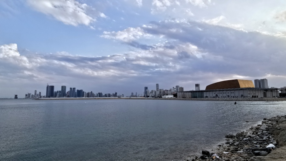
Above: View of Bahrain’s capital city, Manama, from near the Bahrain National Theatre (seen on right)
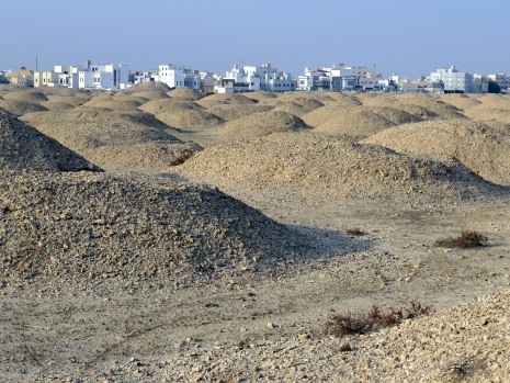
The whole of the northern coastal region of the Arabian Peninsula was once known as Bahrain, with present-day Bahrain being known as Dilmun. In Sumerian times, it was described as “an island of immortals where heroes went after death to live in eternal bliss”. In fact, as we shall see on this webpage, Bahrain effectively has the largest cemetery anywhere in the world, with over 170,000 burial mounds, dating from 2500-1800 BC located throughout the main island of Bahrain. The burial mounds range in size from small bumps to mounds as high as 12m (40 feet). As many have been pillaged by grave robbers throughout the millennia, not many archaeological artefacts have survived.
 |
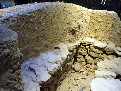 |
Above: Site of the A’Ali Royal Burial Mounds (left) and a full-sized cross sectional burial mound as exhibited in the Bahrain National Museum (right)
Page Contents
A General Description of Bahrain’s Land and People
A Brief Note About
the Visit
Al Budaiya Beach
King Fahd Causeway
Sheikh Salman Bin Ahmad Al
Fatih Fort (Riffa Fort)
Tree of Life
Dar Al Naft Oil Museum
Bahrain
International Circuit
A’Ali Royal Burial Mounds
Saar Temple
Bahrain Fort
& Museum
Manama
Bahrain National Museum
Muharraq Island
Other Sights
References and Further Reading
Above: Fully zoomable map centred on Bahrain (Google Maps)
A General Description of Bahrain’s Land and People
The chain of islands that comprise Bahrain are effectively an archipelago which lies 24km (15 miles) off the northeast coast of Saudi Arabia and 21km (13 miles) northwest of the Qatar Peninsula. Only five of its islands are inhabited with the capital city of Manama located on the north-eastern tip of Bahrain Island. Bahrain’s second-most important island, Muharraq, is where the ruling family live and this is connected to the island of Bahrain by a 2km (1.5-mile) long causeway. A bridge also connects the islands of Bahrain and Sitra. The minor islands include the Muhammadiya and Hawar groups, with Qatar disputing the possession of the latter. Including reclaimed land, the total land area of Bahrain is 780km² (300 square miles), about 77% of which is the island of Bahrain.
The nation’s terrain is generally low-lying and only on the main island of Bahrain does the land ride to more than 100m (328ft). It is I effect a desert, surrounded by sea, although freshwater springs bubble up from beneath the coastal waters – these “wells” are marked by iron posts that rise above the surface of the water; freshwater is also obtained from artesian wells at the northern end of Bahrain Island. The summers here are hot and humid (up to 48ºC/120ºF, 80% humidity) and most rainfall (approx. 7.6cm/3 inches per year) is limited to the cooler, damp winter months (down to 10ºC/50ºF, up to 90% humidity). During wintertime, the “shamal” (a wind from the southeast) brings damp air and occasional dust storms, whilst in summertime, “gaws” (winds from the southwest) bring with them hot air and blinding sandstorms. Once irrigated from the wells, Bahrain’s soil is highly productive, enabling fruit and vegetables to be grown. The land is otherwise dry and sandy and there is little here in the way of livestock farming. Plant life in Bahrain is restricted to date palms and desert plants, whilst fauna includes gazelles, mongooses, desert rats, rabbits, snakes and lizards. A large wildlife refuge at Al-Andareen is home to a variety of exotic birds, gazelles, ibex and oryx.
 |
 |
 |
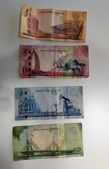
Bahrain’s early wealth came from the fresh water that bubbled up from its artesian wells and springs; its fresh water supply was easier to obtain than anywhere else on the Gulf coast. Pearling from offshore oyster beds also played a major role in the local economy. In the 1930’s, when the Japanese introduced cultured pearls, Bahrain’s economy became under threat. However, the discovery of oil in Bahrain in 1931, followed by its first oil well and then the first oil refinery on the Arab side of the Gulf, significantly changed the dynamics of the local economy. Since those times, Bahrain’s economy has been dominated by the exportation of crude oil and gas, and petroleum products from the large oil refineries here. Although production has always been much smaller than other Arab states, oil has given the country an important source of income, as has the refining of light crude oil piped in from neighbouring Saudi Arabia. In addition, Bahrain’s massive aluminium smelter provides the largest non-oil production industry in the Gulf. Shipbuilding and ship repair work, transit trade and agriculture (mainly on the irrigated northern coast of Bahrain Island) also play a role in the economy. The country has also seen growth in the banking and communications sectors in recent years, with heavy investment in these, as well as in the tourism sector.
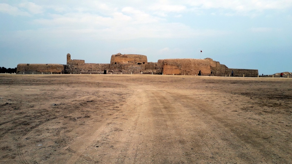
Above: Bahrain Fort, built by the Portuguese in the 16th century
A brief history of Bahrain follows: Bahrain was ruled by Persia (now Iran) for a time in ancient history and also from 1602 until 1783, when the Al-Khalifa Arab family expelled them. The Portuguese laid claim to the islands in 1521, but were forced out by the Persians in 1602. Since 1783, the Al-Khalifa family have been the ruling family and have remained so, ever since; they are cousins of the Al-Sabah ruling family of Kuwait and also distantly related to Saudi Arabia’s Al-Saud ruling family. Bahrain had for many years been used by pirates as a base for attacking ships in the Gulf. However, British political control began in 1820 when an agreement was signed for Bahrain to become a British-protected state. This meant that Britain would protect Bahrain’s sovereignty in return for safe sailing in the Gulf for British vessels; Bahrain kept the pirates from attacking Britain’s ships, whilst Britain prevented the Iranians, amongst others, from attacking Bahrain. Oil was discovered here in 1931 and this led to the formation of the Bahrain National Oil Company, with the first oil well opening in 1932. After Britain withdrew in 1971 and Iran had abandoned claims to the islands, the country proclaimed independence and joined the Arab League. Britain and Bahrain, however, still work together on matters relating to the military and security. The country comprises approximately 60% Shiite and 40% Sunni Muslims and tension between the two communities increased, leading to suspension of the National Assembly in 1975. Alongside other members of the Gulf Cooperation Council, Bahrain repeatedly called for an end to the Iran-Iraq War (1980-88), whilst retaining its neutrality not only then, but also during the Gulf War (1991). Bahrain’s economy became increasingly diversified as oil reserves shrank. Increasing opposition to the country’s rulers and demands for the restoration of the National Assembly led to rising civil unrest during the mid-1990’s. Bahrain’s emir subsequently brought in changes to establish greater democratic representation in 1996. However, calls for greater democracy were not fully resolved and during the Arab Spring Uprising of 2011, inspired by the scenes in Tunisia in Egypt, people across the Middle East and North Africa began taking to the streets in protest towards their leaders. Led by the country’s main opposition party, Al Wefaq, members of Bahrain’s marginalised Shiite community followed the regional wave of protests and occupied Pearl Roundabout in central Manama for days, effectively bringing the country’s capital city to a standstill. The scenes led to calls to overthrow the ruling Al-Khalifa family. On the 4th day of the uprising (17th February, 2011, known as “Bahrain’s Bloody Thursday”), the national security forces launched a pre-dawn raid to clear Pearl Roundabout of the protesters, many of whom were asleep in tents at the time. Four protesters were killed and about 300 injured. A month later, Bahrain called in troops from Saudi Arabia and the United Arab Emirates to clear the protests, as well as destroying the pearl statue, which had come to symbolise the demonstrations. A three-month state of emergency was declared and during this time, a large crackdown was made with thousands of arrests and much criticised torture of some of those involved. Demonstrations continued until November 2012, when such public gatherings were made illegal. Since that time, sporadic incidents have continued.
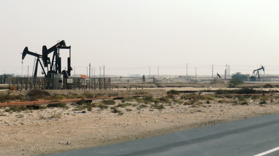
Above: Oilfields in Bahrain
As of 2018, Bahrain’s estimated population was approximately 1.57 million, compared with a population of 1,234,571 recorded in the 2010 census. Approximately 70% of the country’s population are Muslim, 14-15% Christians, 10% Hindus, and about 2.5% Buddhist, with numerous other minority faiths. Roughly a third of the population are foreign-born, many of them Indian, Pakistani, Iranian, or European expatriate workers, and there are also large numbers of Arab immigrants. Most of Bahrain’s growing population is concentrated in the two principal cities, Manama and Al Muharraq. The official language is Arabic and English is a recognised language. As one might expect from the demographics, it is not uncommon to hear people speaking in other languages, such as Farsi and Urdu. Education in Bahrain is free, as is healthcare to all of its citizens.
For this visit, a relatively short return flight was taken from Kuwait
City. More typically, people fly in from elsewhere – as a relatively
small nation, it is very well connected with a large number of major
global carriers flying in and out of Bahrain International Airport.
There is a wide range of accommodation available in Bahrain, with the
modestly priced Bahrain Carlton Hotel in Manama’s bohemian neighbourhood
of Adliya (not to be confused with the Ritz-Carlton) chosen for this
stay. The rooms were clean and spacious and the buffet-style breakfast
was equally satisfactory. A car was hired at the airport, to facilitate
easy sightseeing (tours are available though, from e.g. Visit Bahrain –
link
Here).
The sites described below on this webpage are in the
general order they were visited and these are followed by a brief
description of other sights to see here, alongside general photos taken
during the stay.
First off, a drive was taken from Bahrain’s capital city, Manama, to have a look at the King Fahd Causeway (next section). The plan was to view it from a suitable waterfront location along the northern side of Bahrain Island’s west coast. The location chosen was the beach at Al Budaiya, a coastal town located in the north-western region of Bahrain Island, in the Northern Governorate.
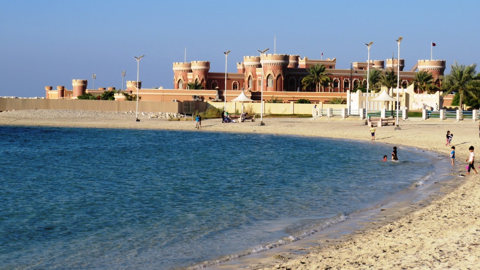
Above: Al Budaiya Beach
Bahrain has several beautiful beaches, although some are privately owned. The pubic ones provide an ideal spot for relaxation and recreation alike, and beach-culture is part of life here. The beach provided some views of the King Fahd Causeway and although partially obscured (e.g. by Jidda Island), the visit to the beach here was nonetheless enjoyed and included an insight into local life, away from work and domestic life. Facilities at Al Budaiya Beach Park include the beach itself, parking (including disabled access), walking paths, grassy areas ideal for picnicking, a kid’s playground, basketball and volleyball courts, and rental for pedal-boats, kayaks and jet-skis. Some photos from the visit to Al Budaiya Beach are shown in the thumbnail gallery below (click on an image to enlarge):
As mentioned earlier, Bahrain Island is connected to Saudi Arabia by the
25km (16-mile) King Fahd Causeway. It comprises a series of bridges and
causeways connecting the two nations and was constructed to improve the
links and bonds between them. Surveying began in 1968, construction
began in 1981, and it officially opened to the public in 1986. One
upshot of its planned construction was that in 1967, Bahrain changed
from driving on the left to driving on the right in order to bring it
into line with neighbouring countries. The project cost a total of
US$800 million and involved the construction of the causeway to carry a
four-lane road, using 350,000 m³ (12,000,000 cubic feet) of concrete
along with 47,000 metric tonnes of reinforced steel. The project
included the construction of a 66-hectare (163-acre) artificial island
(embankment No.4), known as Middle Island, or Passport Island. On the
island are several buildings and facilities. These include buildings
associated with the border station, the King Fahd Causeway Authority,
two mosques, two Coast Guard towers, two 65m (213 foot) high restaurant
towers, services and petrol stations. The west side of the island is
designated as Saudi Arabian and the east side as Bahraini and each side
has its own McDonalds. The island also includes extensive landscaping.
On average, approximately 25,000 vehicles use the causeway each day.
A
drive was taken up to Middle Island, to take a look around the Bahraini
side (no visit was made to Saudi Arabia here). At the time of the visit,
due to reconstruction works, the restaurant tower was closed and so a
visit was made to the McDonalds – perhaps one of the more unusual
locations of their global chain. A walk was taken around, just to get a
feel for the place and to take in the views of each coastline and the
photographs from this side-trip are shown in the thumbnail gallery below
(click on an image to enlarge):
Sheikh Salman Bin Ahmad Al Fatih Fort (Riffa Fort)
The next place visited during the stay in Bahrain was Sheikh Salman Bin Ahmad Al Fatih Fort. Commonly known as Riffa Fort due to its location in Riffa, it is about half an hour’s drive south from the centre of Manama. This historic landmark was built in 1812 by Sheikh Salman Bin Ahmad Al Fatih, the 19th-century ruler of Bahrain, and has been completely restored.
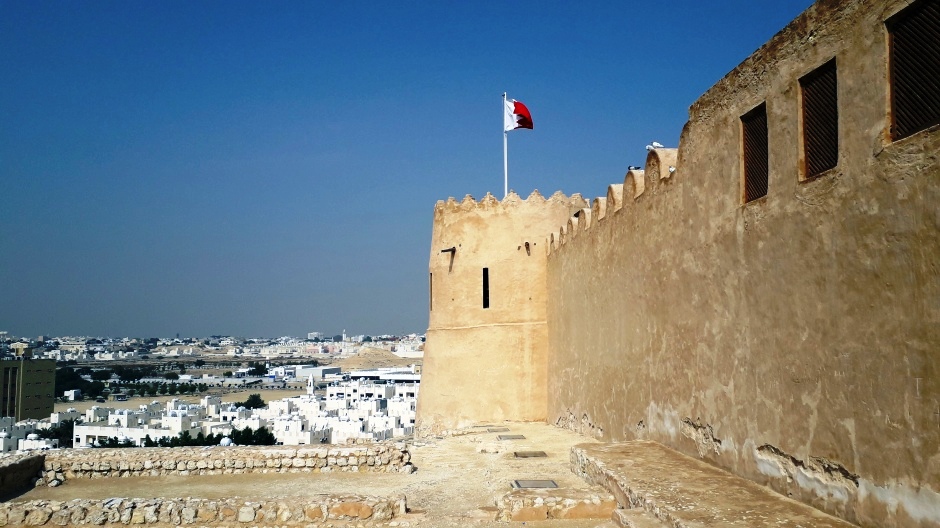
Although another source claims that Riffa Fort was built during the rule of the Persian Safavid Empire over Bahrain during the 17th century, the fort was used as a residence for the Sheikh and its location is somewhat stunning, with commanding views across the Hunainiyah Valley. Riffa was home to the seat of government until 1869 and the fort here is of considerable historical significance. Architecturally, the fort represents a classic and beautiful example of Bahraini fortification. Unfortunately, it was only possible to walk around the perimeter walls at the time of the visit, although the visitor who is able to enter, will see that inside, there is a small museum with raised walkways leading through a series of interactive exhibitions which bring life back to the fort, as they present a chronological history of the Al-Khalifa family. Overlooking the valley today is a modern outdoor terrace, particularly recommended when the café here is open and the atmosphere is enhanced during times when prayer is called. In addition to the fort itself, the fort’s mosque is near the northern corner and just down the road is Bahrain Military Museum. More photographs from the visit to Riffa Fort can be viewed in the thumbnail gallery below (click on an image to enlarge):
The Tree of Life is believed to be more than 400 years old and stands alone on a small hill in the middle of Bahrain’s southern desert, 40km south of Manama. This alluring knotty mesquite tree spreads its old limbs over its surroundings and its almost magical charm attracts hundreds of visitors daily. It is still not known exactly what sustains the Tree of Life, though the underground water source it depends on is probably the same one which was used by inhabitants of a small village which once stood close to here.
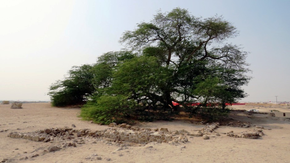
It is possible to walk right up to the tree and whilst admission is free, even at times when there are no other visitors, because of its national significance and importance, a security guard is employed around the clock, so don’t be surprised if there is someone sitting on a chair in its shade. A sunken walkway marked by 19 display boards of other famous trees from around the world circumnavigates the Tree of Life, transforming it into a natural sculpture. The walkway is effectively an outdoor galley where visitors can learn about the importance of trees for the environment. Each of the 19 display boards are positioned according to the geographical direction of each renowned tree from around the world described, informing the visitor of its name, location, direction and distance from Bahrain’s Tree of Life; the Tree of Life has many “sisters” in other nations which also enjoy a particular status in their natural context and country of origin. The effect of the circular walkway is that visitors may experience the Tree of Life from different distances and perspectives, as they walk around it; the tree is not in the centre of the circular path, so it can be seen at varying distances/sizes. Parts of the walkway provide public facilities for the visitor, including an amphitheatre (for spring events and special occasions such as the Bahrain International Music Festival in October), a roofed gallery dedicated to the Tree of Life. The walkway and its wall enable the inner ring to be void of vehicles, making access to the Tree of Life only on foot. This barrier also helps protect the tree and maintain its freshness; in the past, visitors have caused an issue with pollution from cars, as they were previously able to drive right up to the tree’s branches. The immediate area surrounding the tree is empty from other green elements, giving it the effect of looking like a single green spot on a large plain light-coloured canvas. The Tree of Life would have once literally just been a lone tree in the desert. The tree is lit up after dusk, which although apparently well worth seeing, can be difficult driving as the uneven roads leading to and from it have no street lights. Photographs from a visit to the Tree of Life can be viewed in the thumbnail gallery below (click on an image to enlarge):
About a 10 minute drive northwest of the Tree of Life (and a 40 minute drive away from Manama) and more-or-less centrally located on Bahrain Island is the Dar Al-Naft Oil Museum. The museum is housed in an impressive white stone building, complete with neoclassical pillars and seems rather out of character for its setting, amongst the pipelines and nodding donkeys of the surrounding desert landscape. Just to the left of the museum can be seen Bahrain’s first oil well which opened in 1932 and to the right of the museum is the Bahrain Petroleum Company’s (Bapco’s) original small office building, which dates from 1931. As seemed to be the case with several sights in Bahrain, despite signs indicating otherwise, the museum was closed at the time of the visit (this is perhaps why guided tours or phoning ahead are sometimes suggested). However, several items of interest were on display outside the museum and, the visit was made worthwhile by being able to see the first oil well, at the site where oil was first discovered in Bahrain. For those able to go inside, the museum itself details the search, discovery and development of oil and the oil industry in Bahrain and its impact on this island nation. Exhibits and photographs provide insights into the industry which transformed the country into the rich nation it is today; the museum aims to tell the story of Bahrain’s transformation from a “pearl state” to an “oil state” and documents how a search for fresh water led to a search for oil. One of the things that surprised the author of this webpage during the visit was that although this is the site of Bahrain’s very first oil well which dates from 1932, in close proximity to it could be seen active nodding donkeys still pumping oil here. Immediately to the west of Dar Al-Naft Oil Museum stands Jebel Ad Dukhan (the “Mountain of Smoke”), the country’s highest point, named so because of the haze that often surrounds it during humid days. Photographs taken from the visit, showing Bahrain’s first oil well, the museum building, and the small original Bapco office, can be seen in the thumbnail gallery below (click on an image to enlarge):
A few miles directly to the west of Dar Al-Naft Oil Museum (although requiring a detour due to the terrain) lies one of Bahrain’s major attractions, Bahrain International Circuit (BIC). The nation’s Formula 1 circuit is contained within a state-of-the-art motorsport facility, located in the heart of the Sakhir Desert. The circuit incorporates many features of local culture and was designed by the renowned German engineer Hermann Tilke (the same architect who designed the Sepang circuit in Malaysia). The facility was built in just 18 months at a cost of approximately US$150 million and was opened by HM the King of Bahrain in March 2004. The track surface material used was greywacke aggregate, shipped in from a quarry in Shropshire, England, and highly acclaimed in the world of Formula 1 for the high level of grip it offers. Bahrain International Circuit actually consists of six different track layouts, namely the 5.412km/3.363-mile Grand Prix track, the 2.55km/1.58-mile Inner track, the 3.664km/2.277-mile Outer track, the 3.7km/2.3-mile Paddock Circuit, the 1.2km/0.75-mile Drag Strip, and the 2km/1.24-mile Oval track. A full Circuit here totals 6.299km (3.914 miles). Bahrain International Circuit features five FIA certified track layouts, more than anywhere else in the world. The range of tracks allows the circuit to host not just Formula 1, but a whole range of motor racing events throughout the year, including endurance racing, drag racing, and superbike races. Dominating the track is the 8-storey VIP Al Sakhir Tower, which rises above the desert like a beacon. Although not here for the unforgettable experiences of attending an F1 Grand Prix (or any other event here), it was still possible to walk in straight to the stands to take a look ad also browse numerous items in the shop. For those visiting here on non-race days, 40-minute tours take place here, visiting the media centre, control room and the track. For further information on Bahrain International Circuit, events, ticketing and the like, the official website may be found on the link Here. Photographs taken from a brief visit here are shown in the thumbnail gallery below (lick on an image to enlarge):
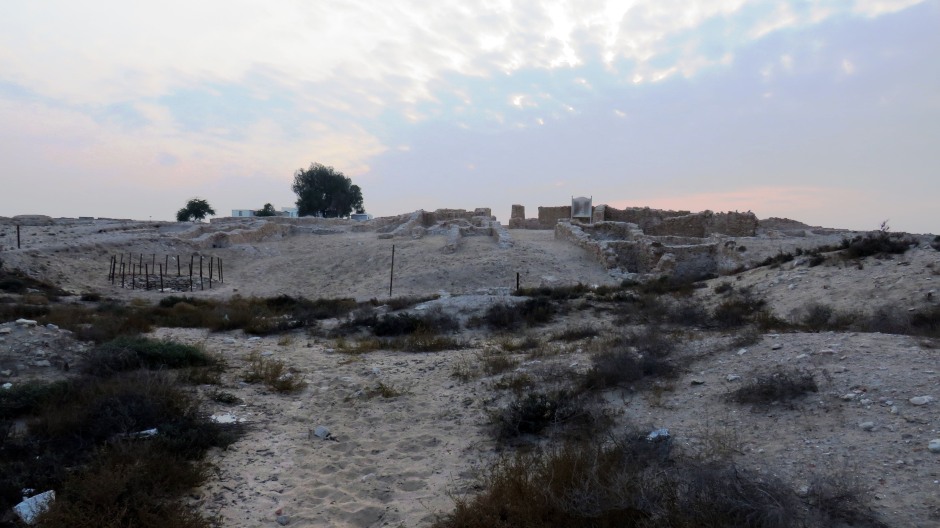
As mentioned earlier on, Bahrain effectively has the largest cemetery anywhere in the world, with over 170,000 burial mounds, dating from 2500-1800 BC located throughout the main island of Bahrain. As a matter of fact, these burial mound cemeteries comprise 5% of Bahrain’s land area. In these ancient times, Bahrain was home to the Dilmun culture, of which comparatively little is known. The Dilmun people had seafaring vessels and traded with other people in the region and according to some theories, the people buried on Bahrain Island were not all local inhabitants, rather transported here to be buried.
Above: Scrollable panning stitch photograph of the A’Ali Royal Burial Mounds site (East Burial Mound Field)
Of the many burial mound sites on Bahrain Island, a specific visit was
made to the A’Ali Royal Burial Mounds, due to the site’s sheer size and
historical significance. The site is a 20km (12½-mile) drive southwest
of Manama. A’Ali’s importance is evidenced from the 17 royal mounds
constructed here, the most notable being “royal mound 8”, measuring some
12m (39 feet) high and 50m (164 feet) across, and containing five
individual chambers. Bahrain’s Dilmun Burial Mounds are a UNESCO World
Heritage Site and as part of this, the A’Ali Royal Burial Mounds are
mapped out as the smaller West Burial Mound Field and the much larger
East Burial Mound Field, the latter which was visited here (the two
fields are separate insofar as a main road runs over the site, splitting
it into two parts).
The A'Ali East Burial Mound Field is the largest
of all the cemeteries in Bahrain, both in dimension and number of burial
mounds. It contains 4,669 tumuli of varying size, mainly of Late Type,
dating from around 2050-1750 BC. The northern part of the site contains
several immense burial mounds, as well as larger mounds in general, with
two belonging to the special type mounds with an outer ring wall. The
northern part of the site contains various mounds of interest, due to
different structural forms, including several grave chambers cut into
bedrock which were once covered by a mound – unusual insofar as Early
Dilmun graves are normally above the surface. Some of the mounds at the
cemetery here are positioned in small groups or chains, possibly
attributable to the natural composition of the ground; like in ancient
times, a few wadis naturally cross the site. Early archaeological
excavations of the site began with the smaller Late Type mounds (to test
excavating skills), prior to conducting excavations of the royal mounds.
Much of this work was carried out during the latter half of the 20th
century. Items recovered from the site have included bronze weapons, an
ivory figurine, several pottery shards, animal remains (sheep and goat),
and as one might well expect, human remains. Some of the skeletons found
were intact, whilst others were scattered – a consequence of ancient
grave robbery. The visit here proved to be a truly inspiring site
indeed, if nothing else, for the sheer size of it and was truly
complemented by a visit to the Bahrain National Museum in Manama, where
inside the Hall of Dilmun Graves, it was possible to view a full-sized
cross sectional burial mound and learn more about this fascinating
aspect of Bahrain’s ancient culture. Some more photographs taken at the
A’Ali East Burial Mound Field are shown in the thumbnail gallery below
(click on an image to enlarge):
Located around half an hour’s drive west, and slightly south, from Manama is located Saar Temple and Burial Chambers. This large site includes a Dilmun-era temple, surrounded by a range of buildings still awaiting formal identification as to what their exact functions were. The temple itself stood in an elevated position in the middle of a Bronze Age settlement at the junction of two main streets. It was constructed around 1900 BC, at a time when the settlement was extensively remodelled during Bahrain’s “City II” period, and would have remained in use for 150-200 years, by which time, many of the surrounding houses would have already fallen into a state of disrepair.
Saar Temple was built using local rough limestone, a contrast to the
smoothly-cut masonry found at Bahrain’s Barbar Temple. The Saar Temple
was built in an irregular shape, perhaps to enable it to fit between
existing structures, although its western corner includes a loop of
wall, the purpose of which remains unclear. Immediately in front of the
temple were some circular stands, or offering tables, and a single
entrance would have led into the main chamber of the temple, as well as
a subsidiary storeroom in the western corner. There, buttresses in the
long walls and one each in the centre of the short walls indicate where
the main roof beams would have been positioned, supported by three
central columns. None of the roofing material remains; it was most
likely constructed with layers of palm fronds laid over beams and poles
and sealed with a mud plaster. The temple would have undergone a series
of modifications during its lifetime, although for most of its life, it
would have only had the main chamber and subsidiary room. All activities
associated with worship of the settlement’s gods must have taken place
in the main chamber. With no written evidence, there is only speculation
as to what the temple and its worship was dedicated to.
The rear of
the temple was used for the storage of jars and boxes containing food
and other items required for the temple rituals. A number of discarded
seals were found here – these would have been broken off when the
storage containers were opened. The small room in the west corner of the
temple provided additional storage space, perhaps for the more valuable
items. Outside the temple, the stands or offering tables in the public
streets would most likely have had some sort of religious function. They
were set in sand and unlike the internal altars, there is no evidence of
burning at them, suggesting they served a different purpose. They may
have been where people placed their personal donations and offerings to
the temple, or they may have been pedestals on which to display statues
or symbols of the gods, perhaps only on special occasions. The temples
role in the religious life of the settlement’s people is undisputed; its
elevated position and attention to architectural detail strongly
suggests this. What the nature of the settlement’s inhabitant’s belief
system was is difficult to determine, although whatever it was, it most
likely shared some characteristics with neighbouring societies.
The
large site here also includes a series of honeycombed burial chambers
south of the temple. These have unfortunately been plundered in days
gone by, with the removal of the coping stones revealing the captivating
interiors. The Saar Temple and Burial Chambers are apparently going to
be turned into a tourist attraction, although at the time of the visit,
there was no evidence of this. Only a single, weathered, information
board and one small set of steps inside, to assist with peering over the
walls, indicated that this was indeed the correct site and known to
others. A large IKEA store on the horizon somewhat spoilt the character
of the place. Otherwise, wandering in to the ancient site here,
unchecked, with no one else around, made one feel that like an
adventurer discovering it for the first time.
More photographs from
the visit to Saar Temple and Burial Chambers, taken with a phone, as
well as a conventional camera, are shown in the thumbnail gallery below
(click on an image to enlarge):
Bahrain Fort (Qal’at Al-Bahrain), or Portuguese Fort, is a UNESCO World Heritage Site (designated in 2005) located on the northern coast of Bahrain Island, 6.3km (3.9 miles) as the crow flies west of the centre of Manama. Known as Dilmun in ancient times, Bahrain’s rich trading history is reflected in numerous archaeological sites and perhaps the most important one is the Bahrain Fort site. Despite its name, “Bahrain Fort”, this major settlement site is not just the imposing fortress which can be seen here, facing the sea. The site here is believed to have been the capital of the ancient Dilmun Empire and provides historians with an outstanding insight into not only the strength of the Dilmun Empire, but also its successors during the Tylos and Islamic periods. Bahrain Fort a true tell (artificial hill), covering 17.5ha (43.2 acres), consisting of a thick accumulation of archaeological layers built up over its long history, starting with the first human constructions towards 2200 BC and ending with the site’s gradual abandonment in the 17th century AD. Archaeological work has revealed this location to contain a succession of urban levels, almost unique in the Gulf region, with approximately 8m (26 feet) of dwelling layers of different thicknesses, according to each of the historical phases, separating the first Bronze Age settlement at the base of the tell, from the Islamic fortress and dwelling levels seen at the centre of the site. Not surprisingly, given the extent of the archaeology here, this is where the most important finds have been made in Bahrain.
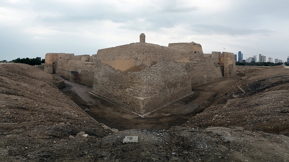
Above: Panoramic stitch photograph of Bahrain Fort (I)
The Bahrain Fort site comprises four main components: The archaeological
tell which was formed over time by successive occupation, a sea tower
(about 1.6km/1 mile northwest of the tell) which was built to guard the
entrance channel, the sea channel that was once the lifeline of trade in
the region, and the terrain surrounding the site, namely palm groves and
traditional agricultural gardens.
The main fort itself was built by
the Portuguese in the 16th century and is well worth exploring. Inside,
display boards provide information about the site’s history during each
period and not only does walking around the structure atop its walls
provide excellent views, but there is plenty of opportunity to take in
its many architectural features. Not to be missed are steps which lead
up to the piazza-like centre atop the tell. Although the author of this
page was not with children, perhaps an idea to keep them visible at all
times – there is plenty of scope for losing them in this large fort
where there is a tendency for inspired minds to drift off. Outside the
walls of the main fort, it is possible to wander around the site,
viewing various excavations that have taken place over the past 50-odd
years; the public, military, religious, commercial and residential
structures, which can be seen, testify to the importance of this site
that has been continuously inhabited by people since 2300 BC.
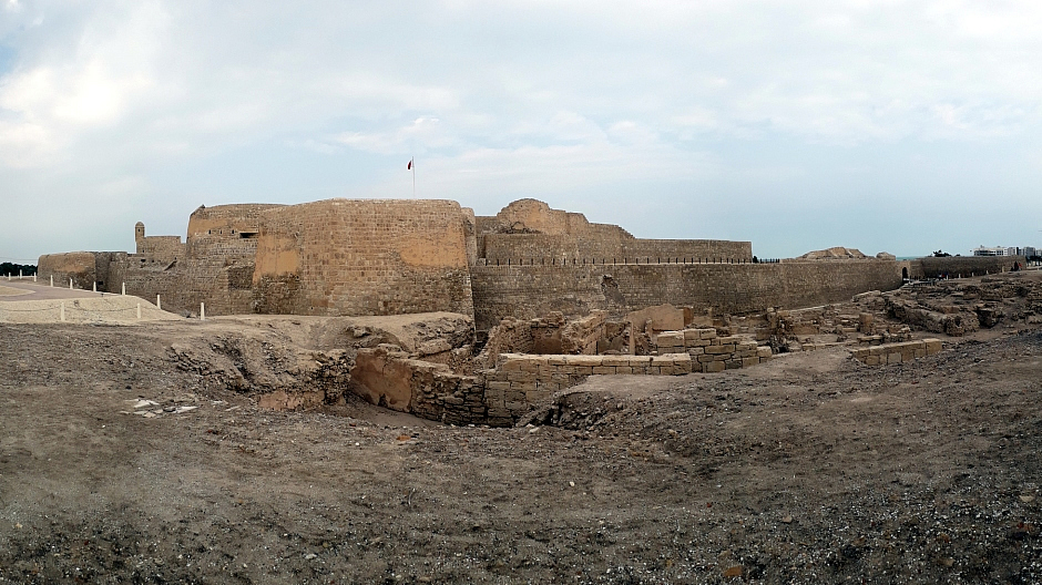
Above: Panoramic stitch photograph of Bahrain Fort (II)
A well laid out path not only encircles the main fort, but also connects it to a tastefully constructed museum/visitors centre, which was inaugurated on the site in 2008. Inside the museum, a representative selection of artefacts found during archaeological excavations are on show in 5 exhibition halls centred around a recreated 30m/100 foot-long tell-wall which illustrates the various strata corresponding to the different periods of occupancy of the site. The museum also has a café, offering stunning views over the sea, the fort and the surrounding palm groves, although it seemed all of these new facilities were closed during the time of the visit, despite plenty of activity elsewhere. More information about Bahrain Fort (“Qal’at Al-Bahrain – Ancient Harbour and Capital of Dilmun”), including downloadable documents, can be found on the UNESCO website Here. More information on the museum, opening times and contact details can be found on the Bahrain Authority for Culture and Antiquities website Here. The extensive thumbnail gallery below shows photographs from a walk around the site, including inside the main fort (click on an image to enlarge):
Bahrain’s capital city, Manama, is located in the north-eastern corner
of Bahrain on a small peninsula. Its population is about 157,000 and for
many years an important trading centre in the Persian Gulf, the city is
home to a very diverse population. Manama has been a city since at least
the 1300’s, recorded in Islamic books, was owned by Portugal from 1521
to 1602, by Persia from 1602 to 1783 and since that time, by the
Al-Khalifa family. The city has been Bahrain’s capital since 1971. Its
name is derived from an Arabic word which means "the place of rest" or
"the place of dreams".
Historically, Manama consisted of what is now
known as the Manama Souq and the Manama Fort (now the Ministry of
Interior) to its south. However, as the city grew, absorbing
neighbouring localities, it now comprises a number of districts. These
include Old Manama (includes the areas of Manama Souq, Fareej el-Fadhel,
Fareej el-Hammam, Fareej el-Hatab, Fareej el-Makharqa, and Fareej
Mushbir), the Diplomatic Area (an “economic powerhouse” of the nation,
with most of the banks and government offices), Gudabiya (the oldest
area of the city and where the parliament is situated), Hoora (one of
Manama's nightlife centres, with a cluster of bars, hotels, restaurants,
pubs and nightclubs), and Seef (a commercial district), to name a few.
Manama is the main centre for Bahrain’s economy. Whilst the petroleum
industry has decreased in importance in more recent years, it is still
the most important in Bahrain, although the primary industry in Manama
itself is financial services. This, along with banking, retail and
tourism has seen growth in more recent years. Several multinationals
have offices and sites in and around Manama. Manama is a financial hub
for the Persian Gulf region and a centre of Islamic banking. The role of
Manama in the Gulf as a regional port city made it a hub for migrant
workers looking for a better living and consequently, the city has often
been described as cosmopolitan. Whilst both Shia and Sunni Muslims have
coexisted here for many years, represented by distinct ethnic groups,
also here are a native Bahraini Christian population, immigrant Hindus
and a small native Jewish community. A large number of foreign nationals
live here. Unlike its much larger neighbour, Saudi Arabia, alcohol is
legal in Bahrain, and so in Manama, bars and nightclubs operate here.
Football is the most popular sport in Manama (and the rest of the
country), with three teams from the city participating in the Bahraini
Premier League. It just so happened that on the last evening spent in
the city, Bahrain had just beaten Saudi Arabia 1-0 in the final of the
Arabian Gulf Cup and consequently the city had become somewhat
gridlocked in places, with cars beeping horns, people leaning out of
vehicles waving the flag of Bahrain, revellers sitting on the backs of
flatbed trucks waving the flag, children running around, and so forth.
As far as visiting Manama as a tourist is concerned, amongst modern
skyscrapers (some of which are somewhat radical in design) there are
plenty of relics and reminders of the city’s heritage as a bustling port
town. Manama’s Souq is very much alive and is a great place for the
atmosphere and to maybe barter for a traditional hand-crafted memento,
or sampling the local globally diverse cuisine.. Perhaps more than any
other city in the region, Manama has a thriving arts scene with
galleries abound.
All of the city’s main sights radiate out from Bab
Al Bahrain, a historical building with a twin-arched gate, located in
the central business district, which marks the main entrance to Manama
Souq, the city’s old bazaar. The financial and diplomatic areas to the
north and east are home to many of the city’s modern buildings,
including the World Trade Center (a remarkable 50-floor twin-towered
complex with three wind turbines mounted on skybridges – the first such
design in the world) and the twin towers of the Financial Harbour
business centre. Close to the causeway for Muharraq Island, in the north
east of the city are Manama’s main cultural venues, including the
Bahrain National Museum (the country’s most popular attraction, featured
in the next section below) and the National Theatre of Bahrain.
Bab Al
Bahrain opened in 1949 and was designed by the British adviser to the
emir, Charles Belgrave. It originally stood by Bahrain’s customs pier
where dhows came to dock. However, land reclamation has meant that the
sea is now further north from this site. Bab Al Bahrain now houses an
information centre. Manama Souq is a series of alleyways and narrow
streets south from Bab Al Bahrain. Selling all manner of items, this
ancient souq is a popular place for tourists to make a beeline for. One
of the communities within the heart of Manama Souq has become known as
“Little India”. Incorporating three streets (Bab Al Bahrain, Al Tijjar
and Al Hadrami Avenues), old Bahraini houses here were constructed with
Indian timber, as well as a 200-year old Krishna Temple. The people here
can be heard speaking Hindi and many of the shop proprietors are
descended from Indians. Providing an authentic Indian atmosphere, this
part of the city is truly unique in Bahrain. Mosques to look out for in
Manama include Al Fatih Mosque (Bahrain’s grand mosque, a modern
elaborate structure which can hold up to 7000 worshippers and is one of
the largest mosques in the world), the small but unusual Sheikh Hussain
Mosque, the Al Khamis Mosque (one of the, if not the oldest mosque in
Bahrain), and the modern Yateem Mosque. As well as Bahrain National
Museum, another popular museum is Beit Al Quran, a multi-purpose complex
dedicated to the Islamic arts in the Hoora district. It is said to
contain the finest collection of ancient Qurans (Korans) in the region,
as well as other documents and other exhibits, all housed in a
spectacular Arabic script engraved building. The museum site also has a
small mosque which has an unusual stained-glass dome. Photographs of
Manama are shown in the thumbnail gallery below. Note that here, some of
the city centre photos are courtesy of the webpage author’s brother.
(Click on an image to enlarge):
Note: Some photos of Manama’s skyline at night may be found in the Muharraq Island section lower down the page (as this is where they were taken from).
As far as this visit to Bahrain is concerned, the Bahrain National Museum was truly one of the highlights, offering an outstanding introduction to the history of this Gulf state. With descriptive signage in English, as well as Arabic, it is the country’s most popular attraction. The museum was officially inaugurated by the late Amir H.H. Shaikh Isa Bin Salman Al-Khalifa in 1988 and is housed in a superb postmodern building centrally located on the waterfront on an artificial peninsula overlooking the island of Muharraq. Considered one of the finest museums in the region, it is one of Bahrain’s main cultural landmarks.
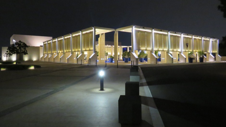
Above: Exterior of Bahrain National Museum after dark
Such was the visit enjoyed so much, and with plenty to see, after
initially heading there for several hours, on the final day of the
visit, it was decided to pay a second visit here, not only to finish
walking around the exhibits in their entirety, but also just to take a
final look to marvel at not only some of the main exhibits, but also the
building – surely amongst the finest architectural designs for a modern
national museum. The building was conceived and designed by Krohn and
Hartvig Rasmussen and characterized by its white travertine marble
façade. The museum comprises two connected buildings – a main building
(housing the permanent exhibition area, temporary exhibition halls, an
art gallery, a lecture hall, gift shop and café) and an administrative
building (housing offices, research areas, conservation laboratories,
exhibition construction and collection storage areas).
The museum’s
collection represents some 6,000 years of Bahrain’s history. There is a
separate art gallery, the large dramatic Grand Foyer (here, the floor is
decorated with a vast scale map of the country, and the space includes
the “Investing in Culture” exhibition) and six main exhibition halls
(three semi-connected and accessed from the lobby and three of the same
size and shape on an upper level). The lower exhibition halls comprise
the Hall of Dilmun Graves, a hall containing the archaeological finds of
ancient Dilmun and a hall dedicated to the customs and traditions of
Bahrain. The three upper halls contain exhibits on the Tylos and Islamic
periods, historic documents and manuscripts, and finally, a hall
dedicated to traditional trades and crafts, which includes a
reproduction of an old souq. The museum café is recommended for its
appealing space and includes a terrace overlooking the bay to the
Bahrain National Theatre. Perhaps, to the author of this webpage, the
highlight of the museum was the Hall of Dilmun Graves, where after
seeing so many burial mounds scattered around the northern half of
Bahrain Island (A’Ali Royal Burial Mounds in particular – see further up
this webpage), it was very interesting to get an insight into what may
typically be found inside them. The museum truly helps enhance visitors’
understanding and knowledge of Bahrain’s history, locals and from afar,
young and old alike.
The photographs shown in the thumbnail gallery
below have been placed in general order of the galleries as numbered on
the museum signage (see guide to exhibits in photo 1) and follow thus:
Grand Foyer / “Investing in Culture” exhibition (photos 1-10), Art
Gallery (photos 11-17), The Hall of Dilmun Graves (photos 18-61), Dilmun
(photos 62-96), Tylos and Islam (photos 97-127), Documents and
Manuscripts (photos 128-131), Customs and Traditions (photos 132-154),
and Traditional Trades and Crafts (photos 155-196). The museum signage
also indicates a Temporary Exhibitions Hall, although nothing was on
display here at the time of the visit. Photographs taken from outside
the museum by day, and then by night (photos 197-224), conclude the
thumbnail gallery below (click on an image to enlarge):
Muharraq Island is the second largest island in the archipelago of
Bahrain after Bahrain Island. It is located just east of Manama, linked
by three causeways. The island is named after Muharraq City, the former
capital of Bahrain (until 1932). The island is regarded as the spiritual
home of all things traditional in Bahrain, and has some of the most
attractive historic buildings in the country. The Al-Khalifa family
settled on the island in the nineteenth century and resided there until
1923. Also, Muharraq Island dominated trade, fishing and the pearling
industry in Bahrain. Thus today, former royal residences and restored
houses of wealthy pearl merchants can be seen during a visit here.
“Pearling, Testimony of an Island Economy” was made a UNESCO world
heritage site in 2012, comprising seventeen buildings in Muharraq City
(including residences of wealthy merchants, shops, storehouses and a
mosque), three offshore oyster beds, part of the seashore and the Qalat
Bu Maher fortress on the southern tip of the island, from where boats
once set off for the oyster beds. The island is also home to many of
Bahrain’s galleries and smaller museums. To the north of the island is a
large area of reclaimed land, with new developments such as the Dragon
City Bahrain shopping mall springing up, and to the south of the island
the new Bahrain International Investment Park of the free zone (BIIP)
has been constructed. In addition, the new Khalifa bin Salman harbour
opened in 2009. As well as the city of Al Muharraq itself, there are
several towns and villages located on Muharraq Island. Bahrain
International Airport is also located on the island (as well as the
smaller Muharraq Airfield adjacent to it).
Ideally, a day could be
spent wandering through Muharraq City’s atmospheric and historic narrow
streets, although unfortunately, time only permitted an evening here.
First off was a stop just southeast of the Sheikh Hamad Causeway to
admire the skyline view of Manama across the water. From here, a walk
around the historic centre of Al Muharraq. Then, a visit to the island’s
town of Arad, to look at a historic fort of the same name.
Sites to
look out for in the historic centre of Al Muharraq include the must-see
Beit Sheikh Isa Bin Ali Al Khalifa (a fine house constructed around 1800
and the seat of Bahraini power from 1869-1932), Beit Seyadi (a
traditional pearl merchant’s house with an old mosque attached to it),
the Busaad Art Gallery, The Sheikh Ebrahim Bin Mohammed Al Khalifa
Centre for Culture and Research, Al Nukhida House (relates to diving
within the pearling industry), Al Korar House (named after the craft of
gold-thread weaving which is preserved here), The Abdullah Al Zayed
House for Bahraini Press Heritage (over 100 years old and former home of
the “father of Gulf newspapers”), Vertical Garden (an arch and wall
planted with tropical plants from around the world), Bin Matar House (a
pearling history museum housed in a traditional house), and last but not
least, Muharraq Souq and the historic Souq Al Qaisariya near its
southern end. South of the historic centre of Al Muharraq and at the
city’s southern tip in the neighbourhood of Halat Bu Maher (sometimes
abbreviated to “Al Hala”) is, as the name suggests, Qalat Bu Maher or
Abu Maher Fort. This is an ancient defence fort built c. 1840. As well
as walking to the fort from the historic centre of Muharraq City, it can
be accessed via a small shuttle boat from the Bahrain National Museum in
Manama (buy tickets inside); the fort can be seen in the distance from
outside the Bahrain National Museum. To the northeast of the historic
centre of Muharraq City can be found the Al Oraifi Museum, which
contains art and sculpture relating to the Dilmun era. One final popular
site on Muharraq Island lies on another part of the island, just east of
Al Muharraq, in the town of Arad, is (again as the name suggests) Qalat
Arad or Arad Fort. The name Arad comes from the Greek name for Muharraq,
Arados, and the historic fort here was constructed in the early 15th
century by the Portuguese. Although there is nothing much to see inside
it, the beautifully restored structure is in an equally beautiful
setting, overlooking the bay and next to a park.
The photographs in
the thumbnail gallery below include views of Manama from Muharraq
Island, the historic centre of Muharraq City, and the fort at Arad. Note
that here, some of the photos are courtesy of the webpage author’s
brother. (Click on an image to enlarge):
There are plenty of other sites in Bahrain which could have been visited had there been more time. Below is a final thumbnail galley of photos taken during the visit aside from the places featured thus far (again, click on an image to enlarge):
The text which follows mentions some of the other places of interest in
Bahrain not discussed above. As well as the Royal Burial Mounds, the
residential town of A’Ali is also known for having the country’s best
pottery district, where traditional family-run business continue to this
day. The village of Al Jasra, just south of where the King Fahd Causeway
begins (or ends), is known for Al Jasra House (a former royal homebuilt
in 1907 and the birthplace of former emir Sheikh Isa Bin Salman Al
Khalifa) and also the government-run Al Jasra Handicraft Centre. As well
as Riffa Fort, the area around Riffa includes Al Bahair Mini Canyon and
Wetlands, a natural wonder and bird haven in wintertime. As well as the
Bahrain International Circuit (where a range of motor-related
“experiences” may be had, recreational attractions in Bahrain include
Adhari Park (an amusement park based around the historic Ain Adari
freshwater spring), Al Areen Wildlife Park & Reserve, Azizia Bird
Kingdom, “Gravity” (indoor skydiving), Karting-BIKC, The Lost Paradise
of Dilmun (set as Bahrain's biggest waterpark), the Royal Golf Club, and
“Wahoo!” (the Middle East’s first ever indoor-outdoor waterpark). The
beach resort of Al Dar Island is a popular place and activities around
the Dar islands include pearl diving (regulated in Bahrain), cruises to
the sandy beach at Jarada Island, dolphin-watching along the many
surrounding coral reefs, trips out on a traditional dhow, and also trips
out to the Hawar islands wildlife preserve.
Bahrain offers many havens
for lovers of shopping and a selection of potential places to head for
may be found on the Bahrain Tourism & Exhibitions Authority website
Here. The annual Bahrain International Music Festival takes place in
October and includes concerts at various venues across the country.
References and Further Reading
For further reading and information about the sights featured above (and other places in Bahrain which may be of interest to the reader), a few resources are listed below:
1. In situ literature and information notice boards
2. Alexander, F.
(1998). Encyclopedia of world history. New York: Oxford University
Press.
3. Gall, T. (1998). Asia and Oceania. Detroit: Gale Research.
4.
Walker, J. (2019). Oman, UAE & Arabian Peninsula. Lonely Planet.
5.
Map
of Bahrain, with city map of Al Manama, 1985 Geoprojects (U.K.) Ltd.
(2nd Edition, used for reference only and not for navigation as contains
description of country, although not up-to-date)
6. Bahrain on Wikipedia
Here
7. Bahrain Tourism & Exhibitions Authority website
Here
8. Visit
Bahrain website
Here
9. Al Budaiya Beach Park at pointbh.com
Here
10.
Bahrain International Circuit website
Here
11. The Dilmun Burial Mounds
on Wikipedia
Here
12. Dilmun Burial Mounds on UNESCO World Heritage List
Here
13. Dilmun Burial Mounds UNESCO Nomination Text (downloadable from
UNESCO website
Here)
14. Qal’at Al-Bahrain (Bahrain Fort) on Wikipedia
Here
15. Qal’at Al-Bahrain – Ancient Harbour and Capital of Dilmun on
UNESCO website
Here
16. "Pearling, Testimony of
an Island Economy” on UNESCO website
Here
Back to Top